Enable Location

We need your location to show you interesting places around you

Discover nearby places

Find interesting locations and hidden gems around you

Precise directions

Get accurate directions and distances to places

Your location is never shared with other users. It's only used when you tap the location button.

Kelvin Aqueduct

Log in to your account

Start exploring — it's free

Trusted by 62,873 travelers worldwide

Continue with Google
Continue with Apple
or

We will send you a code to connect

By continuing, you accept our Terms and Conditions and our Privacy Policy

Check your inbox

We've sent a pincode in your inbox. Please enter the code below.

Kelvin Aqueduct, Navigable aqueduct in Maryhill, Glasgow, United Kingdom

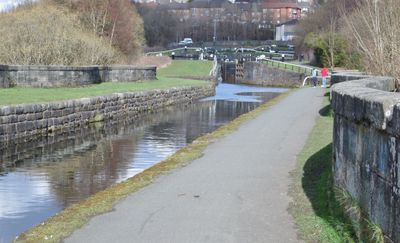
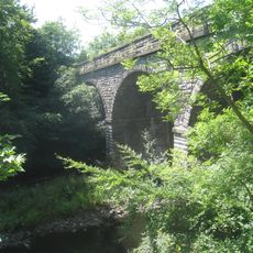
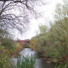
The Kelvin Aqueduct is a navigable canal structure in Glasgow that carries waterborne traffic across a river valley. The construction features multiple stone arches that support the waterway high above the natural landscape.

The aqueduct was completed in 1787 and represented one of the largest canal engineering projects in Britain at that time. Its completion marked a major step forward in connecting trade routes across central Scotland.

The structure stands as a symbol of how people once moved goods and commerce across the landscape using waterways. It represents the engineering ambition of the Industrial Revolution period when canal networks were vital to trade.

You can explore the structure on foot using the nearby walking path that runs beneath and around it. The best time to visit is in dry weather, when the paths are safe and easy to navigate.

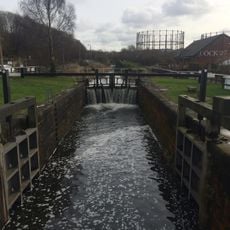
The stonework displays two different textures, mixing finely finished stone at the top with rougher material lower down. This contrast between surfaces becomes more visible as you walk around different sections of the structure.

The community of curious travelers

AroundUs brings together thousands of curated places, local tips, and hidden gems, enriched daily by 60,000 contributors worldwide.

Start exploring
Location
Location
GPS coordinates
55.89235,-4.30173
Latest update
December 13, 2025 11:41
Around this place
Ruchill Church Hall
United Kingdom

Ruchill Church Hall

1.3 km
Dawsholm Park
United Kingdom

Dawsholm Park

837 m
St John's Renfield Church
United Kingdom

St John's Renfield Church

750 m
St Bride's Church, Glasgow
United Kingdom

St Bride's Church, Glasgow

1.4 km
1513 Maryhill Road, Maryhill Community Centre
United Kingdom

1513 Maryhill Road, Maryhill Community Centre

699 m
Ruchill Parish Church
United Kingdom

Ruchill Parish Church

1.3 km
Maryhill Library
United Kingdom

Maryhill Library

703 m
859-869 Crow Road, Temple Anniesland Parish Church
United Kingdom

859-869 Crow Road, Temple Anniesland Parish Church

1.4 km
Maryhill Road, Forth And Clyde Canal, Aqueduct
United Kingdom

Maryhill Road, Forth And Clyde Canal, Aqueduct

571 m
Forth and Clyde Canal: Netherton Farm - Cleveden Road
United Kingdom

Forth and Clyde Canal: Netherton Farm - Cleveden Road

1.4 km
Janitor's House, Kelbourne School, 109 Hotspur Street, Glasgow
United Kingdom

Janitor's House, Kelbourne School, 109 Hotspur Street, Glasgow

1.3 km
Glasgow Lead And Colour Works, 50-56 Ruchill Street, Glasgow
United Kingdom

Glasgow Lead And Colour Works, 50-56 Ruchill Street, Glasgow

1.4 km
Great Western Road, 10 Great Western Terrace
United Kingdom

Great Western Road, 10 Great Western Terrace

1.2 km
No. 5 Gasholder
United Kingdom

No. 5 Gasholder

928 m
Anniesland Station Bridge
United Kingdom

Anniesland Station Bridge

1.3 km
Garrioch Viaduct (L&DR)
United Kingdom

Garrioch Viaduct (L&DR)

1 km
859-869 Crow Road, Temple Anniesland Parish Church, Hall
United Kingdom

859-869 Crow Road, Temple Anniesland Parish Church, Hall

1.4 km
Great Western Road, 53-100 Kelvin Court
United Kingdom

Great Western Road, 53-100 Kelvin Court

1.3 km
Garrioch Viaduct (GCR)
United Kingdom

Garrioch Viaduct (GCR)

1 km
1601 Great Western Road
United Kingdom

1601 Great Western Road

1.4 km
1583-1589 Great Western Road
United Kingdom

1583-1589 Great Western Road

1.4 km
Kelbourne School, 95-109 Hotspur Street, Glasgow
United Kingdom

Kelbourne School, 95-109 Hotspur Street, Glasgow

1.3 km
Kirklee Road, River Kelvin, Kirklee Bridge
United Kingdom

Kirklee Road, River Kelvin, Kirklee Bridge

1.3 km
1605-1609 Great Western Road And 53-57 (odd Nos) Ancaster Drive, Anniesland Mansions Including Boundary Walls
United Kingdom

1605-1609 Great Western Road And 53-57 (odd Nos) Ancaster Drive, Anniesland Mansions Including Boundary Walls

1.4 km
53 Ancaster Drive
United Kingdom

53 Ancaster Drive

1.4 km
75 Hotspur Street, Stow College
United Kingdom

75 Hotspur Street, Stow College

1.4 km
1573-1581 Great Western Road
United Kingdom

1573-1581 Great Western Road

1.4 km
1571 Great Western Road And 57 Ancaster Drive
United Kingdom

1571 Great Western Road And 57 Ancaster Drive

1.4 km
Show the full map
« Kelvin Aqueduct - Navigable aqueduct in Maryhill, Glasgow, United Kingdom » is provided by Around Us (aroundus.com). Images and texts are derived from Wikimedia project under a Creative Commons license. You are allowed to copy, distribute, and modify copies of this page, under the conditions set by the license, as long as this note is clearly visible.

Discover hidden gems everywhere you go!

From secret cafés to breathtaking viewpoints, skip the crowded tourist spots and find places that match your style. Our app makes it easy with voice search, smart filtering, route optimization, and insider tips from travelers worldwide. Download now for the complete mobile experience.

Around Us App Screenshot

A unique approach to discovering new places

Le Figaro

All the places worth exploring

France Info

A tailor-made excursion in just a few clicks

20 Minutes

Around Us
Travel Guide & Maps
Download

Send to your phone

QR Code
1

Open the camera app on your mobile.

2

Point at the QR code with your camera. A notification will appear.

3

Tap the notification to open the link.