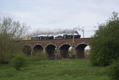
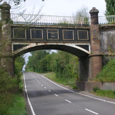
Penkridge Viaduct, Railway viaduct in Penkridge, England
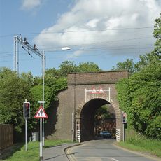
Penkridge Viaduct is a red brick railway bridge crossing the River Penk and Levedale Road with seven arches that feature detailed stonework at their corners. The structure uses engineering brick throughout its construction with ashlar stone accents on the archways.
The viaduct was designed in 1837 by engineer Joseph Locke as part of the Grand Junction Railway project under the direction of Thomas Brassey. This crossing became one of many railway structures built during England's rapid expansion of rail networks in the early Victorian period.
The structure displays Victorian craftsmanship through its red masonry and carefully dressed corners that reflect the era's building standards. Visitors can observe the skill invested in assembling this transport crossing.
The bridge remains in active railway service as part of the Rugby Birmingham and Stafford Line operated by Network Rail. You can view the structure from Levedale Road but should keep a safe distance from the active train tracks.
A locomotive made test runs across the viaduct in June 1837 before the official opening in July of that year. These early trial journeys helped verify the safety and strength of the newly constructed crossing.
Location: Penkridge
GPS coordinates: 52.72740,-2.11880
Latest update: December 14, 2025 18:02
Stretton Hall, Staffordshire
4.3 km
Lapley Priory
5 km
Pillaton Hall
2.7 km
Somerford Hall
6.5 km
Stretton Aqueduct
6 km
St Lawrence's Church, Coppenhall
5.2 km
St John's Church, Stretton
4.4 km
Church of St Leonard
3.4 km
Church of St Michael and All Angels
276 m
Church of St Mary and All Saints
5.5 km
Church of St James
3.5 km
Church of All Saints
5.1 km
Church of All Saints
4.8 km
Shropshire Union Canal Wheaton Aston Bridge Number 18
6.4 km
Aspley Family Memorial Approximately 7 Yards North North East Of West Tower Of Church Of St James
3.5 km
The Railway Inn
443 m
Penkridge Library
562 m
John Barlow Memorial Approximately One Yard South Of Chancel Of Church Of St James
3.5 km
Staffordshire And Worecestershire Canal Acton Moat Bridge
3.6 km
The White Hart
246 m
Cuttlestone Bridge
896 m
Corner House
375 m
Milepost, S of Pottal Pool cross roads
5.1 km
Moat House
3.6 km
Railway Bridge Approximately 20 Yards West Of Church Farmhouse
223 m
Shropshire Union Canal Milepost At Sj 874 104
6.1 km
Tavernor Farmily Memorial And Surrounding Railings Approximately 50 Yards South Of South Aisle Of Church Of All Saints
4.8 km
Cannock Chase War Cemetery
6.3 kmVisited this place? Tap the stars to rate it and share your experience / photos with the community! Try now! You can cancel it anytime.
Discover hidden gems everywhere you go!
From secret cafés to breathtaking viewpoints, skip the crowded tourist spots and find places that match your style. Our app makes it easy with voice search, smart filtering, route optimization, and insider tips from travelers worldwide. Download now for the complete mobile experience.
A unique approach to discovering new places❞
— Le Figaro
All the places worth exploring❞
— France Info
A tailor-made excursion in just a few clicks❞
— 20 Minutes