Enable Location

We need your location to show you interesting places around you

Discover nearby places

Find interesting locations and hidden gems around you

Precise directions

Get accurate directions and distances to places

Your location is never shared with other users. It's only used when you tap the location button.

Stretton Aqueduct

Log in to your account

Start exploring — it's free

Trusted by 63,371 travelers worldwide

Continue with Google
Continue with Apple
or

We will send you a code to connect

By continuing, you accept our Terms and Conditions and our Privacy Policy

Check your inbox

We've sent a pincode in your inbox. Please enter the code below.

Stretton Aqueduct
Discussion Reviews 1 Photos
1.5k Popularity

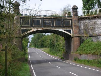
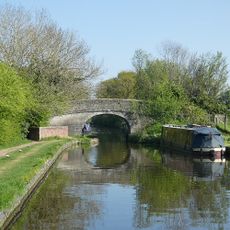
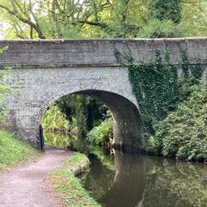
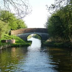
Stretton Aqueduct, Navigable aqueduct in Stretton, England

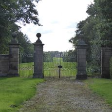
Stretton Aqueduct is a navigable canal bridge built with a cast iron span and blue brick supports on stone piers. The structure crosses over the A5 road and connects two sections of the waterway.

The structure was designed in 1832 by Thomas Telford and completed in 1835. It was part of the canal network expansion across Britain during the height of canal transportation.

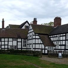
The structure sits among several protected buildings in the area and represents British industrial heritage. Visitors can explore the decorative details and construction methods that show how people shaped canal engineering during that era.

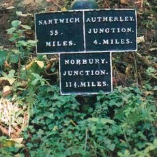
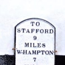
Access is via the canal towpath, which provides continuous routes for walking and cycling through the surrounding countryside. The area is relatively flat and offers easy paths along the water.

The bridge features ornamental cast iron railings set between stone columns topped with domed caps. These decorative touches show how 19th century engineers combined function with visual appeal.

The community of curious travelers

AroundUs brings together thousands of curated places, local tips, and hidden gems, enriched daily by 60,000 contributors worldwide.

Start exploring
Inception
1832
Architects
Thomas Telford
Official opening
1835
GPS coordinates
52.69415,-2.18956
Latest update
December 14, 2025 15:01
Around this place
Royal Oak
United Kingdom

Royal Oak

4.4 km
Boscobel House
United Kingdom

Boscobel House

4.3 km
Chillington Hall
United Kingdom

Chillington Hall

4.1 km
Black Ladies Priory
United Kingdom

Black Ladies Priory

2.9 km
Stretton Hall, Staffordshire
United Kingdom

Stretton Hall, Staffordshire

1.7 km
Lapley Priory
United Kingdom

Lapley Priory

2.2 km
Belvide Reservoir
United Kingdom

Belvide Reservoir

937 m
Somerford Hall
United Kingdom

Somerford Hall

3.8 km
Speedwell Castle
United Kingdom

Speedwell Castle

2.2 km
Mottey Meadows
United Kingdom

Mottey Meadows

3.9 km
St John's Church, Stretton
United Kingdom

St John's Church, Stretton

1.7 km
Church of St Mary and St Chad
United Kingdom

Church of St Mary and St Chad

2.3 km
Church of All Saints
United Kingdom

Church of All Saints

2.2 km
Church of St John
United Kingdom

Church of St John

3.5 km
Church of St Mary
United Kingdom

Church of St Mary

2.8 km
Shropshire Union Canal Wheaton Aston Bridge Number 18
United Kingdom

Shropshire Union Canal Wheaton Aston Bridge Number 18

2.2 km
Shropshire Union Canal Number 13 (School Bridge)
United Kingdom

Shropshire Union Canal Number 13 (School Bridge)

2.3 km
Dean House
United Kingdom

Dean House

2.4 km
Milestone in the grounds of Acorn Cottage
United Kingdom

Milestone in the grounds of Acorn Cottage

4 km
Gate Piers, Gates And Adjoining Walls To North And South At Giffard Cross
United Kingdom

Gate Piers, Gates And Adjoining Walls To North And South At Giffard Cross

3.4 km
Shropshire Union Canal Milepost At Sj 874 104
United Kingdom

Shropshire Union Canal Milepost At Sj 874 104

323 m
Shropshire Union Canal Milepost At Sj 891 060
United Kingdom

Shropshire Union Canal Milepost At Sj 891 060

5.1 km
Speedwell Castle
United Kingdom

Speedwell Castle

2.2 km
Westgate, Forecourt Wall And Gate Piers
United Kingdom

Westgate, Forecourt Wall And Gate Piers

2.4 km
Shropshire Union Canal Canal Milepost Approximately 40 Yards North Of Avenue Bridge (Ngr Sj 88830760)
United Kingdom

Shropshire Union Canal Canal Milepost Approximately 40 Yards North Of Avenue Bridge (Ngr Sj 88830760)

3.5 km
Milepost Shropshire Union Canal 6.5 Miles To South Of Norbury Junction
United Kingdom

Milepost Shropshire Union Canal 6.5 Miles To South Of Norbury Junction

4.4 km
Shropshire Union Canal Sushions Bridge (Number 21) At Sj 847 147
United Kingdom

Shropshire Union Canal Sushions Bridge (Number 21) At Sj 847 147

4.7 km
Milestone, The Smallholding, Crateford
United Kingdom

Milestone, The Smallholding, Crateford

3.9 km
Show the full map
Reviews
Share your experience

No review yet

Discussions
Start a discussion...

No discussion yet

« Stretton Aqueduct - Navigable aqueduct in Stretton, England » is provided by Around Us (aroundus.com). Images and texts are derived from Wikimedia project under a Creative Commons license. You are allowed to copy, distribute, and modify copies of this page, under the conditions set by the license, as long as this note is clearly visible.

Discover hidden gems everywhere you go!

From secret cafés to breathtaking viewpoints, skip the crowded tourist spots and find places that match your style. Our app makes it easy with voice search, smart filtering, route optimization, and insider tips from travelers worldwide. Download now for the complete mobile experience.

Around Us App Screenshot

A unique approach to discovering new places

Le Figaro

All the places worth exploring

France Info

A tailor-made excursion in just a few clicks

20 Minutes

Around Us
Travel Guide & Maps
Download

Send to your phone

QR Code
1

Open the camera app on your mobile.

2

Point at the QR code with your camera. A notification will appear.

3

Tap the notification to open the link.