Robin Hood's Stride, Rock formation in Harthill, United Kingdom
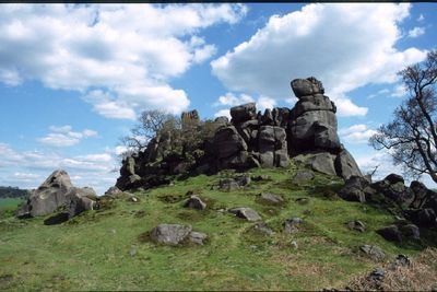
Robin Hood's Stride is a natural gritstone formation with two prominent pillars on Hartle Moor. The two stone columns rise from the moorland landscape and together create a distinctive feature of this part of the British Midlands.
The first documented mention of these gritstone pillars dates to 1817, though older drawings of the area exist without explicitly naming the feature. The structure has changed little over the centuries and remains a stable landmark in the local landscape.
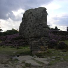
The name comes from a legend about the English folk hero Robin Hood jumping between the two stone pillars to demonstrate his strength. This story has become woven into local identity and shapes how visitors experience the natural formation today.
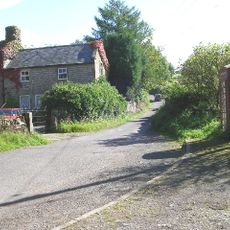
The site is accessible via the Limestone Way, which branches off the B5056 and offers good walking routes. Limited parking is available along the nearby unclassified road, so arriving early is advisable.
The formation also goes by the name Mock Beggar's Hall because its silhouette resembles a manor house with two chimneys at each end. This alternative name shows how differently visitors and local people perceive this distinctive stone formation.
Location: Harthill
Elevation above the sea: 251 m
GPS coordinates: 53.15713,-1.66609
Latest update: December 9, 2025 18:44
Doll Tor
1.5 km
Nine Stones Close
387 m
Andle Stone
1.9 km
St Michael's Church, Birchover
1.2 km
Duke of York Inn
1.4 km
St John the Baptist's Church, Winster
2.3 km
All Saints' Church, Elton
1.3 km
Rowtor Rocks
2 km
Druid Inn
1.2 km
Mill Bridge
2.3 km
Village Well
1.5 km
Footbridge over River Bradford 60 metres south west of Bedford House
2.1 km
The Youth Hostel
1.4 km
Castle Ring defended settlement
667 m
Milestone 150 Metres South West Of Brimsbury Well
569 m
Milestone 15 Metres North Of Stoney Ley Lodge
1.4 km
Cratcliff Rocks hermitage
328 m
Footbridge over River Bradford
2.3 km
Packhorse bridge over River Bradford 120 metres south east of Braemar House
2 km
Stables To The West Of The Duke Of York Inn
1.4 km
Holmedene Farmhouse
1.4 km
Milepost 300 Yards South Of The Junction Of New Road And Chadwick Hill
1.9 km
Road bridge over River Bradford
2 km
Outbuilding attached to south west end of Dale End Farmbuilding
1.5 km
Farmhouse south of Dale End Farmhouse
1.6 km
Homestead Farmhouse And Homestead Cottage
1.3 km
Cliff Farmhouse
696 m
Meadowside
846 mVisited this place? Tap the stars to rate it and share your experience / photos with the community! Try now! You can cancel it anytime.
Discover hidden gems everywhere you go!
From secret cafés to breathtaking viewpoints, skip the crowded tourist spots and find places that match your style. Our app makes it easy with voice search, smart filtering, route optimization, and insider tips from travelers worldwide. Download now for the complete mobile experience.
A unique approach to discovering new places❞
— Le Figaro
All the places worth exploring❞
— France Info
A tailor-made excursion in just a few clicks❞
— 20 Minutes