Sidbury Camp, Iron Age hillfort in Tidworth, England
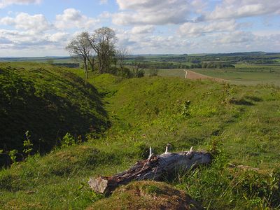
Sidbury Camp is an Iron Age hillfort near Tidworth, on the eastern edge of Salisbury Plain in England, shaped roughly like a triangle and defended on three sides by double ramparts and ditches. The earthworks cover a sizeable area and remain clearly visible across the open chalk downland.
The site was first occupied during the Neolithic period, long before the Iron Age fort was built on the same ground. Excavations in the 1950s brought up pottery and flint tools that confirmed this earlier presence.
Sidbury Camp sits on open chalk downland and its earthworks are visible from a distance, which gives a clear sense of why this spot was chosen for defence. Walking along the ramparts today, visitors can follow the triangular outline of the fort and get a direct feel for how the site was organized.
The site lies close to military training land, so it is worth checking local access notices before you go and sticking to marked paths during your visit. Walking is the best way to take in the full shape of the earthworks, as the outline of the fort becomes much clearer when you move around it.
Trees planted across the site in the 1960s gradually covered most of the earthworks, hiding their shape for decades. When those trees were removed in 2002, the full outline of the ramparts became visible again for the first time in a generation.
The community of curious travelers
AroundUs brings together thousands of curated places, local tips, and hidden gems, enriched daily by 60,000 contributors worldwide.