Enable Location

We need your location to show you interesting places around you

Discover nearby places

Find interesting locations and hidden gems around you

Precise directions

Get accurate directions and distances to places

Your location is never shared with other users. It's only used when you tap the location button.

Tedworth House

Log in to your account

Start exploring — it's free

Trusted by 62,032 travelers worldwide

Continue with Google
Continue with Apple
or

We will send you a code to connect

By continuing, you accept our Terms and Conditions and our Privacy Policy

Check your inbox

We've sent a pincode in your inbox. Please enter the code below.

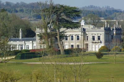
Tedworth House, Grade II listed country house in Tidworth, England

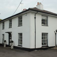
Tedworth House is a two-storey country residence with ornate classical architecture and a prominent south-facing front. The property includes the main building, stable quarters, and a neighboring lodge that together form a cohesive estate arrangement.

The estate was acquired in 1650 by Thomas Smith and converted to a garrison officers' mess in 1897 for the neighboring camp. This transformation marked the shift from a private residence to a military facility that would last more than a century.

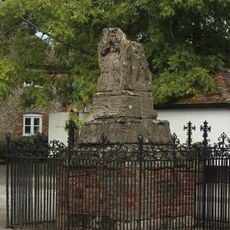
The house carries the name of a famous poltergeist case from the 1600s in the region, which shaped local memory. Visitors walking through the rooms can sense this historical connection and understand why the place holds special meaning for the community.

The site now functions as a recovery center for military personnel and is not always open to the public. It is best to check in advance what areas may be visited or whether group tours are available.

During World War II, the building served as a leisure club for American soldiers stationed in the area. This chapter connects the house to the presence of allied forces that shaped life in the region during wartime.

The community of curious travelers

AroundUs brings together thousands of curated places, local tips, and hidden gems, enriched daily by 60,000 contributors worldwide.

Start exploring
Location
GPS coordinates
51.22660,-1.66812
Latest update
December 10, 2025 16:29
Around this place
Thruxton Circuit
United Kingdom

Thruxton Circuit

5 km
Bulford Kiwi
United Kingdom

Bulford Kiwi

4.9 km
Sidbury Camp
United Kingdom

Sidbury Camp

3.4 km
St Mary's Church, South Tidworth
United Kingdom

St Mary's Church, South Tidworth

319 m
Ludgershall Castle
United Kingdom

Ludgershall Castle

4.8 km
Church of St Peter
United Kingdom

Church of St Peter

2.1 km
The Crown Inn
United Kingdom

The Crown Inn

4.6 km
Church of St James
United Kingdom

Church of St James

4.5 km
Church of St Peter and St Paul
United Kingdom

Church of St Peter and St Paul

4.9 km
Church of the Holy Trinity
United Kingdom

Church of the Holy Trinity

1.5 km
Unidentified Monument In Churchyard, Approximately 16 Metres South Of South Porch, Church Of St James
United Kingdom

Unidentified Monument In Churchyard, Approximately 16 Metres South Of South Porch, Church Of St James

4.5 km
Queens Head Public House
United Kingdom

Queens Head Public House

4.7 km
Kimpton Down Inn
United Kingdom

Kimpton Down Inn

4.7 km
Tidworth Library
United Kingdom

Tidworth Library

1.3 km
Unidentified Monument In Churchyard, Approximately 13 Metres South Of Tower, Church Of St James
United Kingdom

Unidentified Monument In Churchyard, Approximately 13 Metres South Of Tower, Church Of St James

4.5 km
The Thatched Cottage
United Kingdom

The Thatched Cottage

4.7 km
Milestone 1 Mile West Of Ludgershall Village
United Kingdom

Milestone 1 Mile West Of Ludgershall Village

4.3 km
1 and 3, Castle Street
United Kingdom

1 and 3, Castle Street

4.6 km
Ludgershall village cross
United Kingdom

Ludgershall village cross

4.6 km
Shipton Bellinger War Memorial
United Kingdom

Shipton Bellinger War Memorial

2.1 km
15, 17 And 19, Castle Street
United Kingdom

15, 17 And 19, Castle Street

4.7 km
Milestone South-West Of Hougoumont Farm
United Kingdom

Milestone South-West Of Hougoumont Farm

4.9 km
Milestone On Sunnyhill Down
United Kingdom

Milestone On Sunnyhill Down

4.3 km
27, Tidworth Road
United Kingdom

27, Tidworth Road

4.5 km
Milestone 100 Metres North Of Junction With A346
United Kingdom

Milestone 100 Metres North Of Junction With A346

4.9 km
Milestone, N of Bulford Camp; 100m S of MOD red gate
United Kingdom

Milestone, N of Bulford Camp; 100m S of MOD red gate

5 km
Milestone, Thruxton Farm
United Kingdom

Milestone, Thruxton Farm

3.9 km
Milepost, Brigmerston Plantation; 150m S of MOD red gate
United Kingdom

Milepost, Brigmerston Plantation; 150m S of MOD red gate

3.3 km
Show the full map
« Tedworth House - Grade II listed country house in Tidworth, England » is provided by Around Us (aroundus.com). Images and texts are derived from Wikimedia project under a Creative Commons license. You are allowed to copy, distribute, and modify copies of this page, under the conditions set by the license, as long as this note is clearly visible.

Discover hidden gems everywhere you go!

From secret cafés to breathtaking viewpoints, skip the crowded tourist spots and find places that match your style. Our app makes it easy with voice search, smart filtering, route optimization, and insider tips from travelers worldwide. Download now for the complete mobile experience.

Around Us App Screenshot

A unique approach to discovering new places

Le Figaro

All the places worth exploring

France Info

A tailor-made excursion in just a few clicks

20 Minutes

Around Us
Travel Guide & Maps
Download

Send to your phone

QR Code
1

Open the camera app on your mobile.

2

Point at the QR code with your camera. A notification will appear.

3

Tap the notification to open the link.