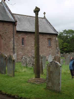
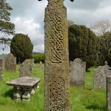
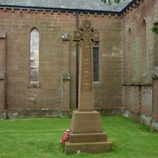
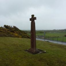
Gosforth Cross, Anglo-Saxon stone cross in Gosforth, England
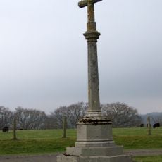
Gosforth Cross is an Anglo-Saxon stone cross standing in the churchyard of St. Mary's Church in Gosforth, carved from red sandstone. It rises to a height of roughly 4.4 meters (14 feet) and shows reliefs with figures and ornamental patterns on all four sides.
The cross was erected between 920 and 950 when Scandinavian settlers took root in the former Kingdom of Northumbria. This period marked the start of a blending between Norse and Christian traditions in the region.
The stone carvings show figures from Norse myths, such as Thor's fishing trip or Vidar fighting Fenrir, while other panels carry Christian motifs. This mixture makes the shift between two belief systems directly readable and visible for today's visitors.
The cross stands in the open churchyard of St. Mary's Church and remains accessible throughout the year. Visitors can walk around the stone to view all carved panels up close.
On the west side of the cross appears a serpent coiling around the lower shaft, still clearly visible today. This serpent figure likely belongs to the depiction of the Midgard serpent from Norse mythology.
Location: Gosforth
GPS coordinates: 54.41945,-3.43105
Latest update: December 5, 2025 22:28
Thermal Oxide Reprocessing Plant
4.6 km
Magnox Reprocessing Plant
4.6 km
Calder Abbey
3.5 km
St Mary's Church, Gosforth
36 m
Irton Cross
3.7 km
Cold Fell
5.8 km
St Bridget's Church, Calder Bridge
3.9 km
Church of St Paul
3.7 km
Church of St Cuthbert
4.2 km
Church of St John the Baptist
6.2 km
Church of St Michael and All Angels
5.2 km
St Peter's Church
4.4 km
Ponsonby Church
3.6 km
Holmbrook Hall Bridge
3.6 km
Milestone On Wall To North West Of High School House
832 m
Gosforth Hall
90 m
Calderbridge War Memorial
3.9 km
Clock Tower At Irton Hall
4.4 km
Medieval Tower Incorporated Into Irton Hall
4.4 km
Calder Abbey House
3.5 km
Old Water Tower To North Of Seascale Sports Hall
4.3 km
Seascale War Memorial
4.2 km
Main House At Irton Hall
4.4 km
Tongue How prehistoric stone hut circle settlements, field systems, funerary cairns, cemetery and cairnfield, Romano-British far
6.1 km
Gatehouse To Calder Abbey
3.6 km
Yeorton Farmhouse
6.2 km
Drigg Holme packhorse bridge
4.9 km
Irton War Memorial, Cumbria
3.6 kmVisited this place? Tap the stars to rate it and share your experience / photos with the community! Try now! You can cancel it anytime.
Discover hidden gems everywhere you go!
From secret cafés to breathtaking viewpoints, skip the crowded tourist spots and find places that match your style. Our app makes it easy with voice search, smart filtering, route optimization, and insider tips from travelers worldwide. Download now for the complete mobile experience.
A unique approach to discovering new places❞
— Le Figaro
All the places worth exploring❞
— France Info
A tailor-made excursion in just a few clicks❞
— 20 Minutes