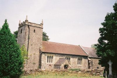
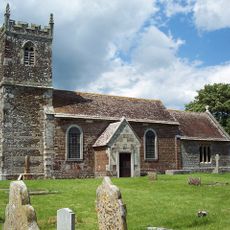
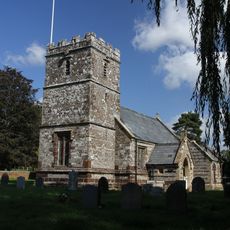
St Mary the Virgin, Lytchett Matravers, Medieval parish church in Lytchett Matravers, England.
St Mary the Virgin is a medieval parish church in Lytchett Matravers with a sturdy west tower crowned by battlements and corner pinnacles, plus a nave containing a four-bay north aisle. The interior displays typical features of an English country church from this period.
The church was founded in the early 13th century, with the tower, nave, and chancel dating to this early medieval period. This structure has endured through the centuries and remains a testament to church building practices of the time.
The church displays furnishings from different periods, including an octagonal font with decorated panels and royal emblems from the time of George IV above the tower arch. These elements speak to the place's importance for the local community across generations.
The church is located on Colehill Road and remains accessible to visitors, particularly those interested in medieval architecture. It is worth checking local times or dropping by when services are held to ensure the building is open for viewing.
In the churchyard stands an ancient yew tree beside the north door that existed for many centuries before the current church was built. This tree is a rare example of the extraordinarily long lifespan of this species.
Location: Lytchett Matravers
Inception: 13 century
GPS coordinates: 50.76507,-2.09224
Latest update: December 13, 2025 12:22
Charborough House
2 km
Church of St Hubert
4.6 km
Saint Aldhelm's Church
3.7 km
Lytchett Heath
3 km
Church of St Mary
3.6 km
Church of St Mary the Virgin
4.5 km
St Mary's Church
2.1 km
Lychett Minster Parish Church
3.9 km
Parish Church of St Mary
4 km
176-188, Church Street
4.5 km
Almer Manor
3.6 km
Charborough Tower
1.5 km
Milestone At Junction Of Road To The World's End Public House
3.3 km
Footbridge Over The River Winterbourne, 200 Metres West Of King Street
4.1 km
Village Cross
4 km
Post Green House
3.5 km
Milepost, Lytchett Minster, opposite Church and School
4 km
Turnpike Boundary Marker Immediately South Of Roundabout At Junction With A35 Road
4.1 km
Churchyard Wall
4.5 km
Milepost Opposite Willow Lodge School
4 km
East Almer Lodge
3.5 km
Milepost, Upton, by British Legion Club
4.6 km
Milestone, grass area opp. St Huberts church
4.6 km
Milestone, Gore Heath
4.6 km
Milestone, 500m S of jct with A35;
3.5 km
Milestone, Huntick Road
1.9 km
Milestone, 50m W of 'Coventry Arms' Pub, outside most westerly house in village
4.4 km
Milestone, Blandford Road, 160m N of cross-roads with Station Rd, in front of Burton Lux
3.3 kmVisited this place? Tap the stars to rate it and share your experience / photos with the community! Try now! You can cancel it anytime.
Discover hidden gems everywhere you go!
From secret cafés to breathtaking viewpoints, skip the crowded tourist spots and find places that match your style. Our app makes it easy with voice search, smart filtering, route optimization, and insider tips from travelers worldwide. Download now for the complete mobile experience.
A unique approach to discovering new places❞
— Le Figaro
All the places worth exploring❞
— France Info
A tailor-made excursion in just a few clicks❞
— 20 Minutes