Enable Location

We need your location to show you interesting places around you

Discover nearby places

Find interesting locations and hidden gems around you

Precise directions

Get accurate directions and distances to places

Your location is never shared with other users. It's only used when you tap the location button.

Stancliffe Hall

Log in to your account

Start exploring — it's free

Trusted by 66,882 travelers worldwide

Continue with Google
Continue with Apple
or

We will send you a code to connect

By continuing, you accept our Terms and Conditions and our Privacy Policy

Check your inbox

We've sent a pincode in your inbox. Please enter the code below.

Discussion Reviews 1 Photos
3.6k Popularity

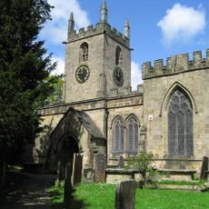
Stancliffe Hall, English country house in Darley Dale, United Kingdom

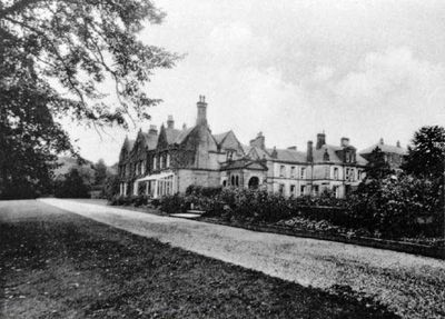
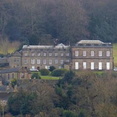
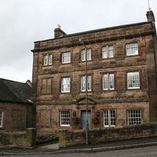
Stancliffe Hall is a stone country house in Darley Dale, Derbyshire, England, built in a Tudor style and later extended with French Renaissance and Victorian features. The building has a large number of rooms spread across several floors, connected by corridors and staircases from different periods.

The Columbell family built the first house on this site in 1670, establishing it as a private country estate. Sir Joseph Whitworth bought the property in 1854 and oversaw a major rebuilding in the French Renaissance style that shaped most of what visitors see today.

The name Stancliffe comes from the family that once owned the land here. Visitors walking through the grounds today can still see how the building shifted in use over the generations, from private home to school to event venue, with each chapter leaving traces in the layout and the rooms.

The house now operates as a wedding and events venue, so checking access in advance is a good idea before making the trip. It sits outside the center of Darley Dale, and arriving by car is the most convenient option for most visitors.

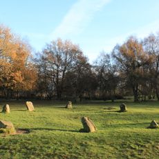
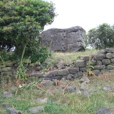
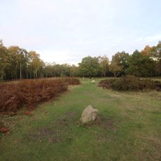
Excavations carried out on the grounds in 1863 turned up Celtic urns, pointing to human activity on this land long before any house stood here. The finds were made beneath what is now the landscaped park surrounding the building.

The community of curious travelers

AroundUs brings together thousands of curated places, local tips, and hidden gems, enriched daily by 60,000 contributors worldwide.

Start exploring
Location
GPS coordinates
53.17210,-1.60120
Latest update
March 3, 2026 14:00
Around this place
Nine Ladies
United Kingdom

Nine Ladies

1.9 km
Stanton Hall
United Kingdom

Stanton Hall

2.7 km
Whitworth Institute
United Kingdom

Whitworth Institute

1.3 km
Andle Stone
United Kingdom

Andle Stone

2.7 km
Parish Church of St Helen
United Kingdom

Parish Church of St Helen

983 m
Holy Trinity Church, Stanton-in-Peak
United Kingdom

Holy Trinity Church, Stanton-in-Peak

2.6 km
Church of St Katherine
United Kingdom

Church of St Katherine

2.5 km
St Mary the Virgin's Church
United Kingdom

St Mary the Virgin's Church

2.5 km
Old Millclose engine house and associated features, 570m south west of Cowley Hall
United Kingdom

Old Millclose engine house and associated features, 570m south west of Cowley Hall

2.3 km
Rowtor Rocks
United Kingdom

Rowtor Rocks

2.7 km
The Flying Childers Inn
United Kingdom

The Flying Childers Inn

2.7 km
Rowsley War Memorial
United Kingdom

Rowsley War Memorial

2.4 km
Rowsley Bridge
United Kingdom

Rowsley Bridge

2.2 km
The Peacock Hotel
United Kingdom

The Peacock Hotel

2.2 km
Village school, attached wall and lavatories
United Kingdom

Village school, attached wall and lavatories

2.1 km
Darley Bridge
United Kingdom

Darley Bridge

1.9 km
Caudwells Mill
United Kingdom

Caudwells Mill

2.1 km
Mile Post 4 Miles From Matlock
United Kingdom

Mile Post 4 Miles From Matlock

1.4 km
Stanton Old Hall
United Kingdom

Stanton Old Hall

2.4 km
Reform Tower
United Kingdom

Reform Tower

1.7 km
Darley Dale Station (Building On North Platform)
United Kingdom

Darley Dale Station (Building On North Platform)

1.4 km
Bronze Age burial, ceremonial and settlement remains on Stanton Moor, and evidence for medieval, post-medieval and 19th to early
United Kingdom

Bronze Age burial, ceremonial and settlement remains on Stanton Moor, and evidence for medieval, post-medieval and 19th to early

2.1 km
Railway viaduct, embankment and overbridge to the east of Church Farm
United Kingdom

Railway viaduct, embankment and overbridge to the east of Church Farm

2.3 km
Bridge House Farmhouse
United Kingdom

Bridge House Farmhouse

2.2 km
Holly House
United Kingdom

Holly House

2.7 km
Milestone, Darley Road; Southern end of Northwood Village
United Kingdom

Milestone, Darley Road; Southern end of Northwood Village

257 m
Milepost, Sydrope Hill, NE of Two Dales
United Kingdom

Milepost, Sydrope Hill, NE of Two Dales

2.1 km
Milestone, Darley Bridge, Wensley, Oaker Road
United Kingdom

Milestone, Darley Bridge, Wensley, Oaker Road

2.7 km
Show the full map
Reviews
Share your experience

No review yet

Discussions
Start a discussion...

No discussion yet

« Stancliffe Hall - English country house in Darley Dale, United Kingdom » is provided by Around Us (aroundus.com). Images and texts are derived from Wikimedia project under a Creative Commons license. You are allowed to copy, distribute, and modify copies of this page, under the conditions set by the license, as long as this note is clearly visible.

Discover hidden gems everywhere you go!

From secret cafés to breathtaking viewpoints, skip the crowded tourist spots and find places that match your style. Our app makes it easy with voice search, smart filtering, route optimization, and insider tips from travelers worldwide. Download now for the complete mobile experience.

Around Us App Screenshot

A unique approach to discovering new places

Le Figaro

All the places worth exploring

France Info

A tailor-made excursion in just a few clicks

20 Minutes

Around Us
Travel Guide & Maps
Download

Send to your phone

QR Code
1

Open the camera app on your mobile.

2

Point at the QR code with your camera. A notification will appear.

3

Tap the notification to open the link.