Whitworth Institute

Log in to your account

AroundUs is a community-driven map of interesting places, built by curious explorers like you. It grows with every review, story, and photo you share.
Connect to save your favorite spots, contribute locations, and create personalized routes.
Continue with Google
Continue with Apple
Continue with X
Continue with Facebook
Continue with email
By continuing, you accept our Terms and Conditions and our Privacy Policy
Create an account
Add to collection
Map
Suggest a change
Share

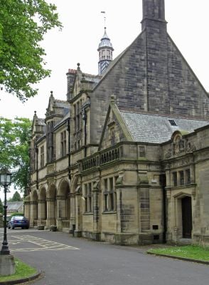
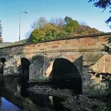
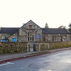
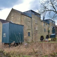
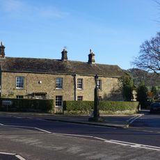
Whitworth Institute, Grade II listed building in Darley Dale, England.

The Whitworth Institute is a Grade II listed building in Darley Dale featuring Free Tudor architecture with Staincliffe stone walls and green Westmorland slate roofing. The structure contains multiple reading rooms, a billiard room, and a large hall capable of accommodating around 200 people for gatherings and events.

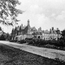
The institute was funded through the estate of Sir Joseph Whitworth and opened to the public in May 1891. Its creation reflected the Victorian movement toward establishing facilities that promoted education and social welfare for working communities.

The building functioned as a community gathering place where people met for reading, games, and social events in separate dedicated rooms. These spaces reflect the Victorian belief that public buildings should support both learning and leisure for all members of society.

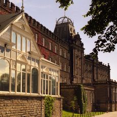
The building underwent major renovation work in 2009/10 to preserve its structure and maintain its usability for ongoing community use. Visitors should plan to explore the different rooms to appreciate how the original layout served multiple purposes.

The building houses a historic swimming bath from the Victorian era, demonstrating how public facilities were equipped for both fitness and leisure activities. This pool was an important part of the comprehensive approach to promoting health and wellbeing in the working community.

Location: Darley Dale

GPS coordinates: 53.16239,-1.59045

Latest update: December 14, 2025 13:07

Photos
Around this place
Nine Ladies
United Kingdom

Nine Ladies

2.6 km
Stancliffe Hall
United Kingdom

Stancliffe Hall

1.3 km
County Hall
United Kingdom

County Hall

3.4 km
Matlock Cable Tramway
United Kingdom

Matlock Cable Tramway

3.5 km
Snitterton Hall
United Kingdom

Snitterton Hall

2.6 km
Andle Stone
United Kingdom

Andle Stone

3.3 km
Parish Church of St Helen
United Kingdom

Parish Church of St Helen

808 m
Church of All Saints
United Kingdom

Church of All Saints

3.1 km
St Mary the Virgin's Church
United Kingdom

St Mary the Virgin's Church

1.6 km
Old Millclose engine house and associated features, 570m south west of Cowley Hall
United Kingdom

Old Millclose engine house and associated features, 570m south west of Cowley Hall

2 km
Rowtor Rocks
United Kingdom

Rowtor Rocks

3.1 km
Mile Stone
United Kingdom

Mile Stone

2.6 km
Rowsley Bridge
United Kingdom

Rowsley Bridge

3.5 km
Village school, attached wall and lavatories
United Kingdom

Village school, attached wall and lavatories

3.4 km
Darley Bridge
United Kingdom

Darley Bridge

919 m
Mile Stone 3 Miles From Matlock
United Kingdom

Mile Stone 3 Miles From Matlock

1.7 km
Caudwells Mill
United Kingdom

Caudwells Mill

3.4 km
Reform Tower
United Kingdom

Reform Tower

2.4 km
Mile Post 4 Miles From Matlock
United Kingdom

Mile Post 4 Miles From Matlock

77 m
Darley Dale Station (Building On North Platform)
United Kingdom

Darley Dale Station (Building On North Platform)

323 m
Mile Stone 2 Miles From Matlock
United Kingdom

Mile Stone 2 Miles From Matlock

3.2 km
Bridge House Farmhouse
United Kingdom

Bridge House Farmhouse

3.5 km
Bronze Age burial, ceremonial and settlement remains on Stanton Moor, and evidence for medieval, post-medieval and 19th to early
United Kingdom

Bronze Age burial, ceremonial and settlement remains on Stanton Moor, and evidence for medieval, post-medieval and 19th to early

2.7 km
Milestone, Darley Road; Southern end of Northwood Village
United Kingdom

Milestone, Darley Road; Southern end of Northwood Village

1.5 km
Milepost, Sydrope Hill, NE of Two Dales
United Kingdom

Milepost, Sydrope Hill, NE of Two Dales

1.5 km
Milepost, entrance to Darwin Forest Country Park, NE of Burnt Piece crossroads (Flash Dam)
United Kingdom

Milepost, entrance to Darwin Forest Country Park, NE of Burnt Piece crossroads (Flash Dam)

3.2 km
Milestone, entrance to Darwin Forest Country Park, NE of Burnt Piece crossroads (Flash Dam)
United Kingdom

Milestone, entrance to Darwin Forest Country Park, NE of Burnt Piece crossroads (Flash Dam)

3.2 km
Milestone, Darley Bridge, Wensley, Oaker Road
United Kingdom

Milestone, Darley Bridge, Wensley, Oaker Road

1.7 km
Show the full map
Reviews

Visited this place? Tap the stars to rate it and share your experience / photos with the community! Try now! You can cancel it anytime.

« Whitworth Institute - Grade II listed building in Darley Dale, England » is provided by Around Us (aroundus.com). Images and texts are derived from Wikimedia project under a Creative Commons license. You are allowed to copy, distribute, and modify copies of this page, under the conditions set by the license, as long as this note is clearly visible.

Discover hidden gems everywhere you go!

From secret cafés to breathtaking viewpoints, skip the crowded tourist spots and find places that match your style. Our app makes it easy with voice search, smart filtering, route optimization, and insider tips from travelers worldwide. Download now for the complete mobile experience.

Around Us App Screenshot

A unique approach to discovering new places

Le Figaro

All the places worth exploring

France Info

A tailor-made excursion in just a few clicks

20 Minutes