Yeaveley Preceptory
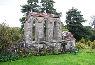
Yeaveley Preceptory, Medieval religious ruins in Yeaveley, England
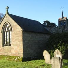
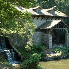
Yeaveley Preceptory is a medieval ruin in England whose surviving stone walls include sections of a chapel built in the early 13th century. The structure was surrounded by a water-filled moat fed by a stream, which enclosed and protected the site.
The site was founded in 1190 when Ralph Foun donated his Benedictine hermitage along with surrounding lands and resources to the Knights Hospitaller. This gift established the foundation for a long period of use as a pilgrimage station.
The preceptory served as a refuge and support station for the Knights Hospitaller, offering shelter and assistance to travelers and pilgrims moving through the region. This role made it a vital stopping point on medieval pathways across the landscape.
The site is defined by a clearly visible moat that separates the central structure from the surrounding landscape. The surviving walls are accessible from several points but allow only partial views of the original building layout.
The site operated fishponds for food production and a dovecote that generated income through the sale of pigeons during the medieval period. These farming structures reveal how the preceptory maintained self-sufficiency and created additional revenue streams.
Location: Yeaveley
GPS coordinates: 52.95677,-1.74545
Latest update: December 14, 2025 16:46
Longford Hall
4.6 km
Church of St Andrew
2.4 km
St John the Baptist's Church, Boylestone
4.3 km
St Chad's Church, Longford
4.6 km
Church of St Martin
4.9 km
Church of St Peter
3.8 km
Church of St James
2.9 km
Medieval settlement, including site of chapel and part of the open field system, immediately north east of Alkmonton Old Hall Fa
3.2 km
Holy Trinity Church
1.5 km
Church of St John
2.1 km
Church of the Holy Trinity
4.9 km
Church of St Giles
4.2 km
War Memorial South West of Church of St Martin
4.9 km
Yew Tree Cottage
4.6 km
Saw Mill
4.6 km
The Saracen's Head Public House
4.9 km
Thatched Cottage
4.9 km
Park View Cottage
4.7 km
Terrace of three cottages opposite the Saracen's Head pub
4.9 km
Stable Block And Coach House At Longford Hall Farm
4.6 km
Snelston War Memorial
4 km
Shirley Mill Farmhouse
4.2 km
The Manor House
4.4 km
Gates And Gatepiers To East Of Longford Hall
4.7 km
Lychgate, Bus Stop And Connecting Retaining Wall To Churchyard
4.3 km
Tinker's Inn bowl barrow, south
4.4 km
Two bowl barrows at Osmaston Fields, north
4.9 km
Wyaston hlaew
2.8 kmVisited this place? Tap the stars to rate it and share your experience / photos with the community! Try now! You can cancel it anytime.
Discover hidden gems everywhere you go!
From secret cafés to breathtaking viewpoints, skip the crowded tourist spots and find places that match your style. Our app makes it easy with voice search, smart filtering, route optimization, and insider tips from travelers worldwide. Download now for the complete mobile experience.
A unique approach to discovering new places❞
— Le Figaro
All the places worth exploring❞
— France Info
A tailor-made excursion in just a few clicks❞
— 20 Minutes