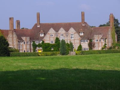
Kelling Hall, Grade II* listed country house in Kelling, England.
Kelling Hall is a red brick country house in Norfolk, England, with five reception rooms and thirteen bedrooms arranged throughout. The residence follows the Arts and Crafts style with a carefully planned butterfly-shaped floor layout that spreads across the structure.
Architect Edward Maufe designed this country house in 1913 for Henri Deterding, a founder of Royal Dutch Petroleum Company. This was Maufe's first major country house project and established his reputation in country estate design.
The hall was built with bricks imported from the Netherlands, showing how early 20th century wealthy patrons drew on international resources. This choice of materials reflects the global connections that shaped the construction methods of the era.
The estate offers holiday properties in the surrounding area, allowing visitors to experience the Norfolk countryside near the North Sea coast. This location makes it easy to explore the region and nearby coastal attractions during a stay.
The grounds feature a shooting lodge, tennis courts, and an outdoor swimming pool that reveal how wealthy families spent their leisure time in the early 1900s. These buildings show the lifestyle expectations of those who owned large country estates.
The community of curious travelers
AroundUs brings together thousands of curated places, local tips, and hidden gems, enriched daily by 60,000 contributors worldwide.