Enable Location

We need your location to show you interesting places around you

Discover nearby places

Find interesting locations and hidden gems around you

Precise directions

Get accurate directions and distances to places

Your location is never shared with other users. It's only used when you tap the location button.

Medway Viaducts

Log in to your account

Start exploring — it's free

Trusted by 62,172 travelers worldwide

Continue with Google
Continue with Apple
or

We will send you a code to connect

By continuing, you accept our Terms and Conditions and our Privacy Policy

Check your inbox

We've sent a pincode in your inbox. Please enter the code below.

Medway Viaducts

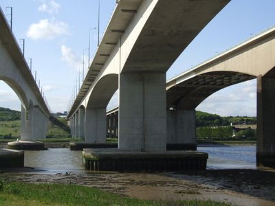
Medway Viaducts, Bridge system in Cuxton, England

The Medway Viaducts comprise three parallel bridges crossing the River Medway, with two structures carrying the M2 motorway and one supporting the railway line. Together, they form a critical transport link between London and the Channel Tunnel.

The original Medway Viaduct opened in 1963 as part of the M2 motorway construction project. Later, extensive renovations took place in the late 1990s, followed by the addition of a new bridge in 2003.

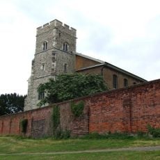
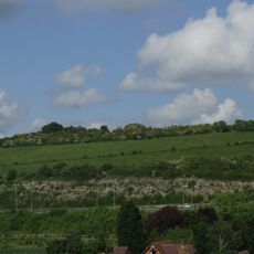
The viaducts connect with the North Downs Way walking route, where hikers can reach elevated viewpoints above the Medway Valley. From these spots, visitors experience the surrounding landscape from a vantage point that reveals the scale of the valley below.

The viaducts are accessible from the North Downs Way walking route, where visitors can view the structures up close from various angles. Plan time to explore different vantage points along the walking path for varied perspectives of the engineering.

A Eurostar train set a British rail speed record of 208 miles per hour while crossing the railway bridge. This achievement demonstrated the structure's ability to handle extreme conditions safely.

The community of curious travelers

AroundUs brings together thousands of curated places, local tips, and hidden gems, enriched daily by 60,000 contributors worldwide.

Start exploring
Inception
September 2003
Official opening
September 2003
GPS coordinates
51.37580,0.47550
Latest update
December 9, 2025 18:42
Around this place
HM Prison Rochester
United Kingdom

HM Prison Rochester

1.1 km
Temple Manor
United Kingdom

Temple Manor

1.7 km
Fort Clarence
United Kingdom

Fort Clarence

1.7 km
St. Margaret's Church
United Kingdom

St. Margaret's Church

2 km
Fort Borstal
United Kingdom

Fort Borstal

1.1 km
Ranscombe Farm
United Kingdom

Ranscombe Farm

827 m
Church of St Michael and All Angels, Cuxton
United Kingdom

Church of St Michael and All Angels, Cuxton

1.5 km
St Margaret's Cemetery Chapels
United Kingdom

St Margaret's Cemetery Chapels

1.8 km
Tomb Chest North Of Nave Of St Margaret's Church
United Kingdom

Tomb Chest North Of Nave Of St Margaret's Church

2 km
Group Of Four Tomb Chests Immediately East Of St Margaret's Church
United Kingdom

Group Of Four Tomb Chests Immediately East Of St Margaret's Church

2 km
Cineworld Cinema Rochester
United Kingdom

Cineworld Cinema Rochester

414 m
Tomb Chest 15 Metres North West Of St Margaret's Church
United Kingdom

Tomb Chest 15 Metres North West Of St Margaret's Church

2 km
Nashenden Farmhouse With Briar Cottage Attached
United Kingdom

Nashenden Farmhouse With Briar Cottage Attached

1.3 km
Wall With Gates Enclosing Churchyard Of St Margaret's Parish Church With Headstones Attached
United Kingdom

Wall With Gates Enclosing Churchyard Of St Margaret's Parish Church With Headstones Attached

1.9 km
Cuxton Library
United Kingdom

Cuxton Library

1.6 km
White Hart House
United Kingdom

White Hart House

1.3 km
Watts' Almshouses
United Kingdom

Watts' Almshouses

2 km
Bell barrow in Shoulder of Mutton Wood
United Kingdom

Bell barrow in Shoulder of Mutton Wood

1.8 km
Whorns Place
United Kingdom

Whorns Place

1.9 km
Morden Terrace
United Kingdom

Morden Terrace

2 km
Foord Almshouses
United Kingdom

Foord Almshouses

1.4 km
Nos 1-47, Cupola In Centre Court, Foord Almshouses Nos 48-64, 1-47
United Kingdom

Nos 1-47, Cupola In Centre Court, Foord Almshouses Nos 48-64, 1-47

1.3 km
Cuxton Signal Box
United Kingdom

Cuxton Signal Box

1 km
Starkey Castle
United Kingdom

Starkey Castle

1.7 km
Two Tomb Chests 8 Metres North Of Nave Of St Margaret's Church
United Kingdom

Two Tomb Chests 8 Metres North Of Nave Of St Margaret's Church

2 km
Gateway To Whorns Place And Cart Shed
United Kingdom

Gateway To Whorns Place And Cart Shed

2 km
Foord Almshouses Nos 1-47 With Gate And Forecourt Walls Attached
United Kingdom

Foord Almshouses Nos 1-47 With Gate And Forecourt Walls Attached

1.3 km
Thorndikes And Former Stable And Coach House Adjoining
United Kingdom

Thorndikes And Former Stable And Coach House Adjoining

2 km
Show the full map
« Medway Viaducts - Bridge system in Cuxton, England » is provided by Around Us (aroundus.com). Images and texts are derived from Wikimedia project under a Creative Commons license. You are allowed to copy, distribute, and modify copies of this page, under the conditions set by the license, as long as this note is clearly visible.

Discover hidden gems everywhere you go!

From secret cafés to breathtaking viewpoints, skip the crowded tourist spots and find places that match your style. Our app makes it easy with voice search, smart filtering, route optimization, and insider tips from travelers worldwide. Download now for the complete mobile experience.

Around Us App Screenshot

A unique approach to discovering new places

Le Figaro

All the places worth exploring

France Info

A tailor-made excursion in just a few clicks

20 Minutes

Around Us
Travel Guide & Maps
Download

Send to your phone

QR Code
1

Open the camera app on your mobile.

2

Point at the QR code with your camera. A notification will appear.

3

Tap the notification to open the link.