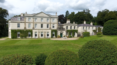
Pixton Park, Grade II* listed country house in Dulverton, England
Pixton Park is a Georgian country house in Dulverton featuring a north-facing entrance, service wing on the east side, and a west wing containing a billiard room added in 1870. The building has been substantially modified over the centuries and remains listed as Grade II*.
The Acland family built the house around 1760 as a Georgian residence. Henry Herbert, the 4th Earl of Carnarvon, made significant expansions in 1870 that shaped the building's current form.
The southern rooms display ornate plaster cornices from the early 1800s that showcase Georgian-era craftsmanship and design. These details remain visible throughout the main living spaces and define the character of the interior.
The house underwent modernization in 1922 with central heating installed and additional service buildings added. Access to the property follows standard visiting hours and may require advance arrangements.
During World War II, the former servants' quarters were converted into rental apartments to adapt to changing needs of the era. This transformation shows how the property responded flexibly to the demands of different periods.
Location: Dulverton
GPS coordinates: 51.03290,-3.53230
Latest update: December 9, 2025 18:41
Combe, Dulverton
1.4 km
Bampton Castle
5.5 km
Ashwick House
5.2 km
Haddon Hill
3.8 km
Barle Bridge
1.6 km
Bury Bridge
1.9 km
Old Church of St James, Upton
5.7 km
Church of St Nicholas, Brushford
1.5 km
St George's Church, Morebath
3.4 km
Church of All Saints
1.5 km
Briggins Moor
3.9 km
Church of St Mary
5.1 km
Bury Castle, Brompton Regis
1.2 km
Market Hall
1.5 km
Church of St Michael
5.9 km
Church of St Michael and All Angels
5.7 km
Bampton Library
5.7 km
Milestone Immediately In Front Of No 32 Brook Street
5.8 km
Leburn House And Lower Leburn, Including Stable Block And Rear Garden Walls
5.7 km
Brompton Regis Lock-Up
5.1 km
Milestone At Ngr Ss 9737 2849
5 km
The Toll-House
2.9 km
Milestone At Ngr Ss 9258 3206
5 km
Milestone At Ngr Ss 93121 29647
2.6 km
Milestone, Cowridge Bottom, above River Exe, 200m N of bends warning sign
4 km
Milestone, Bury Castle, opp. Woodland
1 km
Milestone, 500m S of Somerset border N of Exebridge
1.8 km
Milestone, S of Kent's Farm
3.8 kmVisited this place? Tap the stars to rate it and share your experience / photos with the community! Try now! You can cancel it anytime.
Discover hidden gems everywhere you go!
From secret cafés to breathtaking viewpoints, skip the crowded tourist spots and find places that match your style. Our app makes it easy with voice search, smart filtering, route optimization, and insider tips from travelers worldwide. Download now for the complete mobile experience.
A unique approach to discovering new places❞
— Le Figaro
All the places worth exploring❞
— France Info
A tailor-made excursion in just a few clicks❞
— 20 Minutes