St. Mary's Church, Aldridge

Log in to your account

AroundUs is a community-driven map of interesting places, built by curious explorers like you. It grows with every review, story, and photo you share.
Connect to save your favorite spots, contribute locations, and create personalized routes.
Continue with Google
Continue with Apple
Continue with X
Continue with Facebook
Continue with email
By continuing, you accept our Terms and Conditions and our Privacy Policy
Create an account

St. Mary's Church, Aldridge

Add to collection
Map
Suggest a change
Share

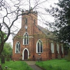
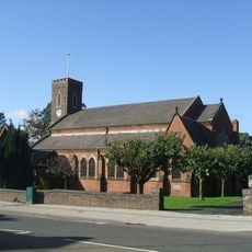
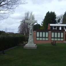
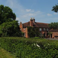
St. Mary's Church, Aldridge, Grade II* listed parish church in Walsall, England

St. Mary's Church is a parish church built in neoclassical style with distinctive architectural details that reflect 19th century design principles. Inside, decorative stained glass windows created by Hardman & Co. complement the marble altar, creating a coherent interior that guides the eye toward the sanctuary.

The building was constructed between 1825 and 1827 under architect Joseph Ireland's direction, marking a significant period in regional religious architecture. This construction followed an earlier period when the growing congregation worshipped at temporary locations.

The church serves as a spiritual center for the local Catholic community, hosting regular services and gatherings that mark the rhythm of the parish year. It remains a visible symbol of Catholic presence in the area and continues to draw people seeking both worship and connection.

The church is open to visitors, particularly during service times, allowing access to view the interior and architectural details. It is best to check opening times in advance and remember to be respectful if attending services or taking photographs inside.

The first Catholic priest trained entirely in England since the Reformation began his ministry here in 1807, representing a turning point in religious acceptance. This appointment demonstrated how attitudes toward Catholic worship had begun to shift in the decades following the relaxation of religious restrictions.

Location: Walsall

Inception: 13 century

Website: http://aldridgeparishchurch.org

GPS coordinates: 52.60430,-1.91260

Latest update: December 14, 2025 18:10

Photos
Around this place
Icknield Street
United Kingdom

Icknield Street

4.4 km
Beacon Way
United Kingdom

Beacon Way

3.8 km
Little Aston Hall
United Kingdom

Little Aston Hall

2.7 km
St Martin's Church Walsall
United Kingdom

St Martin's Church Walsall

3.6 km
Walsall Central Library
United Kingdom

Walsall Central Library

4.9 km
Whittimere Street drill hall, Walsall
United Kingdom

Whittimere Street drill hall, Walsall

4.8 km
Jockey Fields
United Kingdom

Jockey Fields

3 km
St James' Church, Brownhills
United Kingdom

St James' Church, Brownhills

4.9 km
St. Michael and All Angels Pelsall Parish Church
United Kingdom

St. Michael and All Angels Pelsall Parish Church

4.6 km
Aldridge Transport Museum
United Kingdom

Aldridge Transport Museum

1.1 km
Church of St Peter
United Kingdom

Church of St Peter

3.2 km
Church of St Peter
United Kingdom

Church of St Peter

2.9 km
Church of St Michael
United Kingdom

Church of St Michael

3.6 km
The Old Irish Harp Public House
United Kingdom

The Old Irish Harp Public House

1.6 km
The Parish Church of St John
United Kingdom

The Parish Church of St John

2.8 km
Walsall Wood War Memorial
United Kingdom

Walsall Wood War Memorial

2.8 km
Church of St Mark
United Kingdom

Church of St Mark

3.1 km
Streetly War Memorial Cross Outside All Saints' Church
United Kingdom

Streetly War Memorial Cross Outside All Saints' Church

3.1 km
Aldridge War Memorial
United Kingdom

Aldridge War Memorial

49 m
Sandhills Pumping Station
United Kingdom

Sandhills Pumping Station

4.3 km
The Boat House Adjoining Hatherton Lake In Walsall Aboretum
United Kingdom

The Boat House Adjoining Hatherton Lake In Walsall Aboretum

4.4 km
Milepost At Sk 094 005
United Kingdom

Milepost At Sk 094 005

3.4 km
Gate Piers With Attached Wall, Railings And Gates At Main Entrance To Little Aston Hall
United Kingdom

Gate Piers With Attached Wall, Railings And Gates At Main Entrance To Little Aston Hall

3.3 km
Milepost, Chester Road, Streetly, between Bridle Lane & Foley Road jct
United Kingdom

Milepost, Chester Road, Streetly, between Bridle Lane & Foley Road jct

3.2 km
Doe Bank Farmhouse And Farm Building Attached
United Kingdom

Doe Bank Farmhouse And Farm Building Attached

4.8 km
Milepost, SW of Shelfield, outside No. 298 Lichfield Road
United Kingdom

Milepost, SW of Shelfield, outside No. 298 Lichfield Road

3.1 km
Milepost, Walsall Road, by No. 138 , E of jct with A452 (Old Irish Harp PH) in Aldridge Road
United Kingdom

Milepost, Walsall Road, by No. 138 , E of jct with A452 (Old Irish Harp PH) in Aldridge Road

1.9 km
Milepost, Walsall Wood, nr A4152 jct, by No. 183 Lichfield Road, Shire Oak
United Kingdom

Milepost, Walsall Wood, nr A4152 jct, by No. 183 Lichfield Road, Shire Oak

3.2 km
Show the full map
Reviews

Visited this place? Tap the stars to rate it and share your experience / photos with the community! Try now! You can cancel it anytime.

« St. Mary's Church, Aldridge - Grade II* listed parish church in Walsall, England » is provided by Around Us (aroundus.com). Images and texts are derived from Wikimedia project under a Creative Commons license. You are allowed to copy, distribute, and modify copies of this page, under the conditions set by the license, as long as this note is clearly visible.

Discover hidden gems everywhere you go!

From secret cafés to breathtaking viewpoints, skip the crowded tourist spots and find places that match your style. Our app makes it easy with voice search, smart filtering, route optimization, and insider tips from travelers worldwide. Download now for the complete mobile experience.

Around Us App Screenshot

A unique approach to discovering new places

Le Figaro

All the places worth exploring

France Info

A tailor-made excursion in just a few clicks

20 Minutes