Enable Location

We need your location to show you interesting places around you

Discover nearby places

Find interesting locations and hidden gems around you

Precise directions

Get accurate directions and distances to places

Your location is never shared with other users. It's only used when you tap the location button.

Whitehawk Camp

Log in to your account

Start exploring — it's free

Trusted by 63,029 travelers worldwide

Continue with Google
Continue with Apple
or

We will send you a code to connect

By continuing, you accept our Terms and Conditions and our Privacy Policy

Check your inbox

We've sent a pincode in your inbox. Please enter the code below.

Discussion Reviews 1 Photos
7.9k Popularity

Whitehawk Camp, Neolithic causewayed enclosure in Brighton and Hove, England.

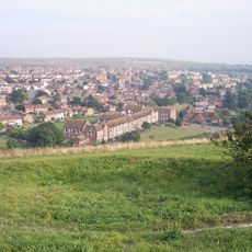
Whitehawk Camp is a Neolithic causewayed enclosure featuring four concentric rings with interrupted ditches spread across the chalk hills of South Downs. The site covers roughly 100 meters and displays the characteristic layout typical of early Stone Age settlements.

This settlement developed roughly 5,500 years ago during the early Neolithic period and ranks among Britain's oldest known human occupation sites. It emerged about 1,000 years before Stonehenge, showing how early communities organized themselves in southern England.

The name likely references hawk watching, an activity significant to Stone Age communities in this region. Local heritage efforts recognize the site as a meeting place where early people gathered to work and share in communal life.

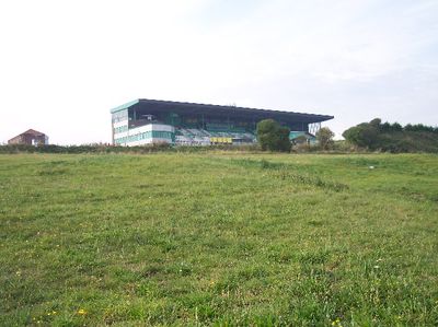
The site is reachable via bus routes 21 and 37, with limited parking available near the Brighton Racecourse grandstand. Visitors should expect uneven ground since the location sits on natural hills and can become muddy in wet weather.

The third bank is the most complete section and clearly shows the structure of interrupted ditches. Many visitors overlook this area, yet it offers the best chance to understand how the original construction worked.

The community of curious travelers

AroundUs brings together thousands of curated places, local tips, and hidden gems, enriched daily by 60,000 contributors worldwide.

Start exploring
GPS coordinates
50.82750,-0.11194
Latest update
December 8, 2025 20:00
Around this place
Pepper Pot
United Kingdom

Pepper Pot

908 m
Queen's Park, Brighton
United Kingdom

Queen's Park, Brighton

1 km
St George's Church, Brighton
United Kingdom

St George's Church, Brighton

1.2 km
Whitehawk Hill
United Kingdom

Whitehawk Hill

148 m
St Joseph's Church, Brighton
United Kingdom

St Joseph's Church, Brighton

1.2 km
St Luke's Church, Queen's Park, Brighton
United Kingdom

St Luke's Church, Queen's Park, Brighton

864 m
St Mark's Church, Brighton
United Kingdom

St Mark's Church, Brighton

1.1 km
Bristol Road Methodist Church
United Kingdom

Bristol Road Methodist Church

1.2 km
St Wilfrid's Church, Brighton
United Kingdom

St Wilfrid's Church, Brighton

790 m
Brighton College Chapel
United Kingdom

Brighton College Chapel

1 km
Brighton Extra Mural Cemetery Cemetery Chapel
United Kingdom

Brighton Extra Mural Cemetery Cemetery Chapel

1.2 km
Brighton And Preston Cemetery Mortuary Chapel
United Kingdom

Brighton And Preston Cemetery Mortuary Chapel

752 m
Playhouse
United Kingdom

Playhouse

1.1 km
Memorial Drinking Fountain 60 Metres North East Of The Lake
United Kingdom

Memorial Drinking Fountain 60 Metres North East Of The Lake

954 m
Woodvale Cemetery Tomb Of John Frederick Ginnett
United Kingdom

Woodvale Cemetery Tomb Of John Frederick Ginnett

996 m
Finsbury Road Board School
United Kingdom

Finsbury Road Board School

1.1 km
1-14 Lewes Crescent
United Kingdom

1-14 Lewes Crescent

1.2 km
Classroom Dining Hall And Head Masters House Brighton College
United Kingdom

Classroom Dining Hall And Head Masters House Brighton College

970 m
Egremont Gate And Attached Wall And Railings
United Kingdom

Egremont Gate And Attached Wall And Railings

1.2 km
Woodvale Crematorium
United Kingdom

Woodvale Crematorium

840 m
Park Street Gate And Attached Walls And Piers And Railings
United Kingdom

Park Street Gate And Attached Walls And Piers And Railings

1.2 km
The Royal Gymnasium And Attached Railings
United Kingdom

The Royal Gymnasium And Attached Railings

1.1 km
Pearson House
United Kingdom

Pearson House

1.2 km
Clock Tower 30 Metres West Of Number 15 East Drive (Number 15 East Drive Not Included)
United Kingdom

Clock Tower 30 Metres West Of Number 15 East Drive (Number 15 East Drive Not Included)

926 m
Woodvale Cemetery North Lodge
United Kingdom

Woodvale Cemetery North Lodge

1.2 km
Tram Shelter
United Kingdom

Tram Shelter

927 m
St Lukes School
United Kingdom

St Lukes School

670 m
1-10 Sussex Square
United Kingdom

1-10 Sussex Square

1.2 km
Show the full map
Reviews
Share your experience

No review yet

Discussions
Start a discussion...

No discussion yet

« Whitehawk Camp - Neolithic causewayed enclosure in Brighton and Hove, England » is provided by Around Us (aroundus.com). Images and texts are derived from Wikimedia project under a Creative Commons license. You are allowed to copy, distribute, and modify copies of this page, under the conditions set by the license, as long as this note is clearly visible.

Discover hidden gems everywhere you go!

From secret cafés to breathtaking viewpoints, skip the crowded tourist spots and find places that match your style. Our app makes it easy with voice search, smart filtering, route optimization, and insider tips from travelers worldwide. Download now for the complete mobile experience.

Around Us App Screenshot

A unique approach to discovering new places

Le Figaro

All the places worth exploring

France Info

A tailor-made excursion in just a few clicks

20 Minutes

Around Us
Travel Guide & Maps
Download

Send to your phone

QR Code
1

Open the camera app on your mobile.

2

Point at the QR code with your camera. A notification will appear.

3

Tap the notification to open the link.