Church of St Michael, Chenies

Log in to your account

AroundUs is a community-driven map of interesting places, built by curious explorers like you. It grows with every review, story, and photo you share.
Connect to save your favorite spots, contribute locations, and create personalized routes.
Continue with Google
Continue with Apple
Continue with X
Continue with Facebook
Continue with email
By continuing, you accept our Terms and Conditions and our Privacy Policy
Create an account

Church of St Michael, Chenies

Add to collection
Map
Suggest a change
Share

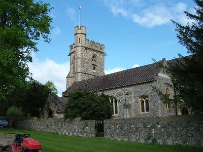
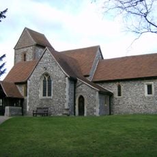
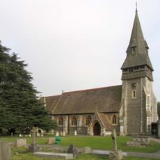
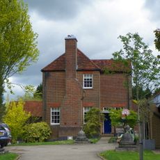
Church of St Michael, Chenies, 15th century Anglican church in Chenies, England

Church of St Michael is a 15th-century stone building with a nave, south aisle, chancel, south porch, and north chapel. A west tower with an external staircase leading to its embattled parapet completes the structure.

The original 12th-century wooden structure was replaced, with the current building constructed around 1450 by Sir David Phelip and his wife Dame Agnes Cheyne. This new construction marked the transition from the medieval predecessor to a substantial stone building.

The Bedford Chapel displays burial monuments of the Russell family spanning four centuries, visible as you walk through. These elaborate tombs tell the story of people who shaped the land and region over a long time.

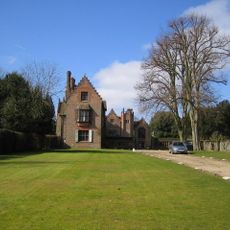
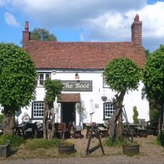
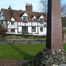
The building sits on Manor House Main Drive and is visible from outside. Visitors typically find the church open for visits, though opening hours may vary by season.

The Norman font dates from the original 12th century and displays a distinctive circular shape in the Aylesbury style. The basin rests on a square base with carved foliage decorations that survived from the earlier church.

Location: Chenies

Inception: 15 century

GPS coordinates: 51.67490,-0.53249

Latest update: December 11, 2025 18:04

Photos
Around this place
Chenies Manor House
United Kingdom

Chenies Manor House

65 m
The Green Dragon, Flaunden
United Kingdom

The Green Dragon, Flaunden

2.4 km
Frogmore Meadows
United Kingdom

Frogmore Meadows

751 m
Sarratt Bottom nature reserve
United Kingdom

Sarratt Bottom nature reserve

1.6 km
Bricklayers Arms Garden
United Kingdom

Bricklayers Arms Garden

3 km
Black Horse Pub
United Kingdom

Black Horse Pub

3.1 km
Church of the Holy Cross
United Kingdom

Church of the Holy Cross

2.3 km
Church of St Mary Magdalene (Church of England)
United Kingdom

Church of St Mary Magdalene (Church of England)

2.4 km
Church of St Mary Magdalene
United Kingdom

Church of St Mary Magdalene

1.6 km
Christ Church
United Kingdom

Christ Church

2.7 km
Milepost, South Of Junction With Chessfield Park
United Kingdom

Milepost, South Of Junction With Chessfield Park

1.7 km
Sarratt Mill House
United Kingdom

Sarratt Mill House

2 km
The Bricklayer Arms Public House
United Kingdom

The Bricklayer Arms Public House

2.9 km
The Boot Public House
United Kingdom

The Boot Public House

2.9 km
Milepost Approximately 30 Metres South Of Chenies Village
United Kingdom

Milepost Approximately 30 Metres South Of Chenies Village

415 m
Latimer Boer War Memorial, Buckinghamshire
United Kingdom

Latimer Boer War Memorial, Buckinghamshire

1.3 km
Barn About 20 Metres North Of Great Bragman's Farm House
United Kingdom

Barn About 20 Metres North Of Great Bragman's Farm House

2.5 km
Great Sarratt Hall
United Kingdom

Great Sarratt Hall

2.8 km
Chenies Chapel (baptist)
United Kingdom

Chenies Chapel (baptist)

587 m
The Ivy House Public House
United Kingdom

The Ivy House Public House

4.2 km
The Lodge
United Kingdom

The Lodge

119 m
Foliots
United Kingdom

Foliots

1.3 km
Great Bragmans Farm House
United Kingdom

Great Bragmans Farm House

2.5 km
8, 9, 10 And 11, Chenies
United Kingdom

8, 9, 10 And 11, Chenies

699 m
Woodside House Gardens
United Kingdom

Woodside House Gardens

332 m
Rose Hill Farmhouse
United Kingdom

Rose Hill Farmhouse

2.6 km
Liberty Tomb (Beside Path To West Of Mill Farm) At National Grid Reference Tq 0098 9877
United Kingdom

Liberty Tomb (Beside Path To West Of Mill Farm) At National Grid Reference Tq 0098 9877

715 m
Milestone, Amersham Road; opp. the Ivy House PH, close to Pollards Wood Golf Course, North Harewood Down House
United Kingdom

Milestone, Amersham Road; opp. the Ivy House PH, close to Pollards Wood Golf Course, North Harewood Down House

4.2 km
Show the full map
Reviews

Visited this place? Tap the stars to rate it and share your experience / photos with the community! Try now! You can cancel it anytime.

« Church of St Michael, Chenies - 15th century Anglican church in Chenies, England » is provided by Around Us (aroundus.com). Images and texts are derived from Wikimedia project under a Creative Commons license. You are allowed to copy, distribute, and modify copies of this page, under the conditions set by the license, as long as this note is clearly visible.

Discover hidden gems everywhere you go!

From secret cafés to breathtaking viewpoints, skip the crowded tourist spots and find places that match your style. Our app makes it easy with voice search, smart filtering, route optimization, and insider tips from travelers worldwide. Download now for the complete mobile experience.

Around Us App Screenshot

A unique approach to discovering new places

Le Figaro

All the places worth exploring

France Info

A tailor-made excursion in just a few clicks

20 Minutes