Enable Location

We need your location to show you interesting places around you

Discover nearby places

Find interesting locations and hidden gems around you

Precise directions

Get accurate directions and distances to places

Your location is never shared with other users. It's only used when you tap the location button.

Senbonmatsu Bridge

Log in to your account

Start exploring — it's free

Trusted by 62,904 travelers worldwide

Continue with Google
Continue with Apple
or

We will send you a code to connect

By continuing, you accept our Terms and Conditions and our Privacy Policy

Check your inbox

We've sent a pincode in your inbox. Please enter the code below.

Senbonmatsu Bridge
Discussion Reviews 1 Photos
8.5k Popularity

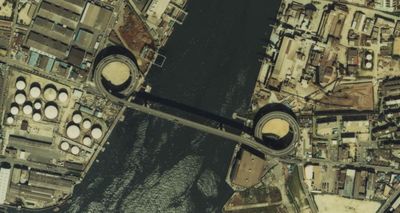
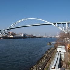
Senbonmatsu Bridge, Road bridge in Taisho district, Osaka, Japan

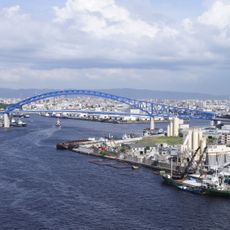
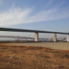
Senbonmatsu Bridge spans 323.5 meters across the Kizu River with distinctive double-spiral approach ramps on each bank and a main steel box girder structure. The crossing connects Nishinari and Taisho districts through vehicle lanes, pedestrian walkways, and bus routes at a height of 33 meters above water level.

The bridge opened in 1973 to connect industrial areas that previously depended on water transport for cargo movement. Its name comes from pine trees that once lined the riverbanks during the Edo period.

Local residents call this structure Megane Bridge because its distinctive double-spiral shape resembles eyeglasses when viewed from above. This nickname is so common in everyday conversation that the official name is rarely used.

Vehicles and pedestrians should expect tight spiral approach ramps that make three complete turns to reach the main span on each side. Driving or walking at a measured pace is advisable, especially during poor weather or for first-time users.

Navigation systems display an unusual rotating pattern as vehicles traverse the spiral ramps. This phenomenon makes the crossing an interesting navigation experience for drivers using GPS technology.

The community of curious travelers

AroundUs brings together thousands of curated places, local tips, and hidden gems, enriched daily by 60,000 contributors worldwide.

Start exploring
Location
Location
Inception
1973
Length
323.5 m
Longest Span
150 m
GPS coordinates
34.63251,135.47592
Latest update
December 8, 2025 19:57
« Senbonmatsu Bridge - Road bridge in Taisho district, Osaka, Japan » is provided by Around Us (aroundus.com). Images and texts are derived from Wikimedia project under a Creative Commons license. You are allowed to copy, distribute, and modify copies of this page, under the conditions set by the license, as long as this note is clearly visible.

Discover hidden gems everywhere you go!

From secret cafés to breathtaking viewpoints, skip the crowded tourist spots and find places that match your style. Our app makes it easy with voice search, smart filtering, route optimization, and insider tips from travelers worldwide. Download now for the complete mobile experience.

Around Us App Screenshot

A unique approach to discovering new places

Le Figaro

All the places worth exploring

France Info

A tailor-made excursion in just a few clicks

20 Minutes

Around Us
Travel Guide & Maps
Download

Send to your phone

QR Code
1

Open the camera app on your mobile.

2

Point at the QR code with your camera. A notification will appear.

3

Tap the notification to open the link.