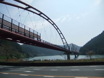
夢のかけ橋, Pedestrian bridge in Tenryu, Japan.
Dream Bridge is a pedestrian and cycling path that spans about 474 meters across Lake Funagira, featuring a distinctive red and white arch. It connects the boat park area with the roadside station and provides easy access to marina facilities and recreational areas along the water.
The bridge was completed in 2000 and reuses four pillars originally built for an unfinished railway project. These recycled structures from the Sakuma Line demonstrate how an abandoned transportation plan found new purpose.
The bridge connects two recreational zones and serves as a gathering point where visitors walk between both shorelines. Its name reflects the local hope of linking these two areas together.
The bridge is open daily to pedestrians and cyclists and provides a level, safe passage between both shorelines. Visitors should check weather conditions, as the water around it becomes quite cold during winter months.
The bridge features a striking red and white paint scheme that is illuminated at night, glowing above the dark water. This lighting makes the crossing particularly beautiful at sunset and after dark.
The community of curious travelers
AroundUs brings together thousands of curated places, local tips, and hidden gems, enriched daily by 60,000 contributors worldwide.