Aspnäset
Location: Ragunda Municipality
Inception: 1847
GPS coordinates: 63.41328,15.58253
Latest update: June 15, 2024 10:11
Öjsjömyrarna Nature Reserve
24.4 km
Hammerdals kommun
21.1 km
Borgvattnets kyrka
12.2 km
Ammerån
12.2 km
Edeforsen
15.4 km
Vackermyren
12.6 km
Helvetesmyrkälen
18.6 km
Hagamarken
13.4 km
Länglingsån
21.5 km
Mörtsjöberget
7 km
Källberget-Storberget
6.4 km
Skallflohålen
7.8 km
Långstrandberget
18.5 km
Skarpåskälabodarna
22.6 km
Lubbäckflon
22 km
Storflohöjden
22.7 km
Finnbodarna
9.2 km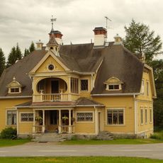
Markusgården
1.1 km
Hammerdal 203:1
14.1 km
Ollsta
22.8 km
Borgflobodarna
18.1 km
Fjällandets badhus
22.3 km
Sönnerbodarna
8.3 km
Nybodarna
3.6 km
Kallsnäs
23.1 km
Kallsnäs
23.1 km
Gammelbodarna
23.2 km
Gamla fäboderna (1762)
23.9 kmReviews
Visited this place? Tap the stars to rate it and share your experience / photos with the community! Try now! You can cancel it anytime.
Discover hidden gems everywhere you go!
From secret cafés to breathtaking viewpoints, skip the crowded tourist spots and find places that match your style. Our app makes it easy with voice search, smart filtering, route optimization, and insider tips from travelers worldwide. Download now for the complete mobile experience.

A unique approach to discovering new places❞
— Le Figaro
All the places worth exploring❞
— France Info
A tailor-made excursion in just a few clicks❞
— 20 Minutes