Enable Location

We need your location to show you interesting places around you

Discover nearby places

Find interesting locations and hidden gems around you

Precise directions

Get accurate directions and distances to places

Your location is never shared with other users. It's only used when you tap the location button.

George C. Platt Bridge

Log in to your account

Start exploring — it's free

Trusted by 63,123 travelers worldwide

Continue with Google
Continue with Apple
or

We will send you a code to connect

By continuing, you accept our Terms and Conditions and our Privacy Policy

Check your inbox

We've sent a pincode in your inbox. Please enter the code below.

George C. Platt Bridge
Discussion Reviews 1 Photos
5.5k Popularity

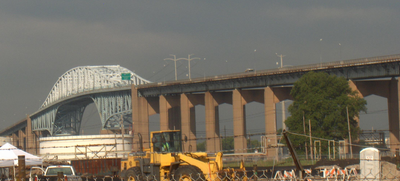
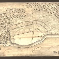
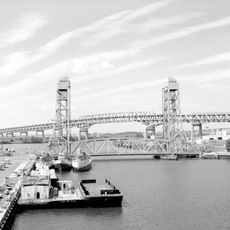
George C. Platt Bridge, Truss bridge over Schuylkill River in Philadelphia, United States.

The George C. Platt Bridge is a truss structure that crosses the Schuylkill River and connects Southwest Philadelphia to the airport district. It carries two directions of Pennsylvania Route 291 and features a steel median barrier designed to prevent head-on collisions between opposing traffic.

The structure opened in 1951 under the name Penrose Avenue Bridge and served from the start as a key connection between areas. It was renamed in 1979 to honor a Civil War veteran.

The bridge's name honors a Civil War figure and was adopted in 1979 to recognize his legacy. Its steel structure and design reflect the industrial character of the area it passes through.

The structure handles heavy daily traffic and features a secure median separation for opposing traffic directions. Pedestrians and cyclists should note that this is a major roadway and no separate paths exist.

The bridge passes directly over an oil refinery and has been temporarily closed during industrial incidents in the past. A notable event was a major fire at a nearby refinery in the mid-1970s.

The community of curious travelers

AroundUs brings together thousands of curated places, local tips, and hidden gems, enriched daily by 60,000 contributors worldwide.

Start exploring
Location
Inception
1951
Official opening
1951
GPS coordinates
39.89810,-75.21170
Latest update
December 9, 2025 18:49
Around this place
Lincoln Financial Field
United States of America

Lincoln Financial Field

3.8 km
John F. Kennedy Stadium
United States of America

John F. Kennedy Stadium

3.4 km
Philadelphia Naval Shipyard
United States of America

Philadelphia Naval Shipyard

2.9 km
Broad Street Line
United States of America

Broad Street Line

3.4 km
United States of America

Fort Mifflin

2.5 km
Bartram's Garden
United States of America

Bartram's Garden

3.6 km
John Bartram High School
United States of America

John Bartram High School

3.2 km
Simeone Foundation Automotive Museum
United States of America

Simeone Foundation Automotive Museum

1.9 km
Fort Mercer
United States of America

Fort Mercer

3.8 km
Red Bank Battlefield
United States of America

Red Bank Battlefield

3.6 km
American Swedish Historical Museum
United States of America

American Swedish Historical Museum

2.8 km
Girard Point Bridge
United States of America

Girard Point Bridge

1.4 km
Statue of Christopher Columbus
United States of America

Statue of Christopher Columbus

3.9 km
Stephen Girard Park
United States of America

Stephen Girard Park

3.5 km
Marine Barracks
United States of America

Marine Barracks

3.2 km
Commandant's Quarters
United States of America

Commandant's Quarters

2.9 km
Joseph W. Catharine School
United States of America

Joseph W. Catharine School

4.1 km
Passyunk Avenue Bridge
United States of America

Passyunk Avenue Bridge

2.6 km
Delaplaine McDaniel School
United States of America

Delaplaine McDaniel School

4.1 km
John M. Patterson School
United States of America

John M. Patterson School

3 km
1200 Intrepid
United States of America

1200 Intrepid

3.4 km
Sesquicentennial Cyclone
United States of America

Sesquicentennial Cyclone

3.5 km
Edgar Allan Poe School
United States of America

Edgar Allan Poe School

3.6 km
George Wolf School
United States of America

George Wolf School

1.9 km
Thomas F Donatucci, Sr., Branch
United States of America

Thomas F Donatucci, Sr., Branch

3.6 km
F. Amadee Bregy School
United States of America

F. Amadee Bregy School

3.5 km
Thomas Buchanan Read School
United States of America

Thomas Buchanan Read School

3.3 km
Universal Vare Charter School
United States of America

Universal Vare Charter School

3.8 km
Show the full map
Reviews
Share your experience

No review yet

Discussions
Start a discussion...

No discussion yet

« George C. Platt Bridge - Truss bridge over Schuylkill River in Philadelphia, United States » is provided by Around Us (aroundus.com). Images and texts are derived from Wikimedia project under a Creative Commons license. You are allowed to copy, distribute, and modify copies of this page, under the conditions set by the license, as long as this note is clearly visible.

Discover hidden gems everywhere you go!

From secret cafés to breathtaking viewpoints, skip the crowded tourist spots and find places that match your style. Our app makes it easy with voice search, smart filtering, route optimization, and insider tips from travelers worldwide. Download now for the complete mobile experience.

Around Us App Screenshot

A unique approach to discovering new places

Le Figaro

All the places worth exploring

France Info

A tailor-made excursion in just a few clicks

20 Minutes

Around Us
Travel Guide & Maps
Download

Send to your phone

QR Code
1

Open the camera app on your mobile.

2

Point at the QR code with your camera. A notification will appear.

3

Tap the notification to open the link.