Enable Location

We need your location to show you interesting places around you

Discover nearby places

Find interesting locations and hidden gems around you

Precise directions

Get accurate directions and distances to places

Your location is never shared with other users. It's only used when you tap the location button.

Irondequoit Bay Outlet Bridge

Log in to your account

Start exploring — it's free

Trusted by 62,467 travelers worldwide

Continue with Google
Continue with Apple
or

We will send you a code to connect

By continuing, you accept our Terms and Conditions and our Privacy Policy

Check your inbox

We've sent a pincode in your inbox. Please enter the code below.

Irondequoit Bay Outlet Bridge

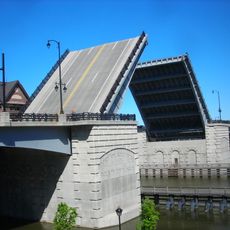
Irondequoit Bay Outlet Bridge, Seasonal road bridge at Irondequoit Bay outlet, New York.

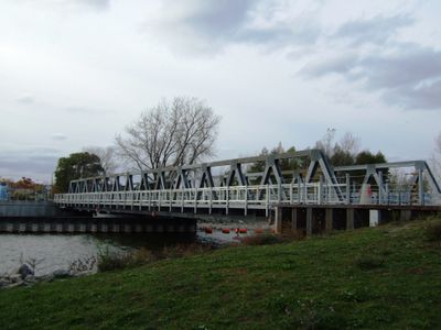
The Irondequoit Bay Outlet Bridge is a steel and concrete structure spanning the northern end of Irondequoit Bay, connecting Culver Road in Irondequoit to Lake Road in Webster. The span measures approximately 186 feet and features a balanced pivot system that allows seasonal operational shifts.

The current structure was built in 1998 and replaced a timber bridge that had served the area since 1929. The replacement was needed to better serve growing traffic and boat navigation demands.

The bridge draws local residents who gather to watch water activity and fish from nearby jetties and beaches.

The bridge shifts seasonally between boat and vehicle use, remaining open for boats from April through October and for vehicles from November through March. Each transition takes about four hours, making the bridge impassable during these changeover periods.

The bridge features an unusual rotating pivot system where the main span is roughly 133 feet and balanced by a counterweighted section of about 53 feet. This mechanical design allows the entire structure to rotate completely, switching between boat traffic and vehicle traffic with precision.

The community of curious travelers

AroundUs brings together thousands of curated places, local tips, and hidden gems, enriched daily by 60,000 contributors worldwide.

Start exploring
Location
GPS coordinates
43.23470,-77.53410
Latest update
December 12, 2025 14:26
Around this place
Seneca Park Zoo
United States of America

Seneca Park Zoo

7.9 km
Jack Rabbit
United States of America

Jack Rabbit

819 m
Saint Michael's Church
United States of America

Saint Michael's Church

9.3 km
Irondequoit Bay Bridge
United States of America

Irondequoit Bay Bridge

2.6 km
Veterans Memorial Bridge
United States of America

Veterans Memorial Bridge

8.4 km
Browncroft Historic District
United States of America

Browncroft Historic District

9 km
Saint Bernard's Seminary
United States of America

Saint Bernard's Seminary

8.2 km
Charlotte-Genesee Lighthouse
United States of America

Charlotte-Genesee Lighthouse

6.6 km
Colonel Patrick O'Rorke Memorial Bridge
United States of America

Colonel Patrick O'Rorke Memorial Bridge

6.4 km
United States of America

WhirlWind

718 m
Parkside Whispering Pines
United States of America

Parkside Whispering Pines

1.3 km
Saint George Roman Catholic Lithuanian Church
United States of America

Saint George Roman Catholic Lithuanian Church

8.6 km
Shingleside
United States of America

Shingleside

7.3 km
Saint Mary the Protectress, Irondequoit
United States of America

Saint Mary the Protectress, Irondequoit

6.4 km
Webster Baptist Church
United States of America

Webster Baptist Church

8.8 km
St. Stanislaus' Church
United States of America

St. Stanislaus' Church

7.5 km
United Congregational Church of Irondequoit
United States of America

United Congregational Church of Irondequoit

5.9 km
Vanderbeck House
United States of America

Vanderbeck House

9.3 km
East Side Presbyterian Church
United States of America

East Side Presbyterian Church

8.2 km
George G. Mason House
United States of America

George G. Mason House

9.1 km
Congregation Ahavas Achim Anshi Austria
United States of America

Congregation Ahavas Achim Anshi Austria

8.8 km
Saint Mark's and Saint John's Episcopal Church
United States of America

Saint Mark's and Saint John's Episcopal Church

7.8 km
House at 288 Wimbledon Road
United States of America

House at 288 Wimbledon Road

7 km
Jayne and Mason Bank Building
United States of America

Jayne and Mason Bank Building

8.8 km
William C. Jayne House
United States of America

William C. Jayne House

9.3 km
Royal Dynasty
United States of America

Royal Dynasty

5.8 km
Maplewood Park
United States of America

Maplewood Park

8.6 km
All Souls Chapel
United States of America

All Souls Chapel

8 km
Show the full map
« Irondequoit Bay Outlet Bridge - Seasonal road bridge at Irondequoit Bay outlet, New York » is provided by Around Us (aroundus.com). Images and texts are derived from Wikimedia project under a Creative Commons license. You are allowed to copy, distribute, and modify copies of this page, under the conditions set by the license, as long as this note is clearly visible.

Discover hidden gems everywhere you go!

From secret cafés to breathtaking viewpoints, skip the crowded tourist spots and find places that match your style. Our app makes it easy with voice search, smart filtering, route optimization, and insider tips from travelers worldwide. Download now for the complete mobile experience.

Around Us App Screenshot

A unique approach to discovering new places

Le Figaro

All the places worth exploring

France Info

A tailor-made excursion in just a few clicks

20 Minutes

Around Us
Travel Guide & Maps
Download

Send to your phone

QR Code
1

Open the camera app on your mobile.

2

Point at the QR code with your camera. A notification will appear.

3

Tap the notification to open the link.