Enable Location

We need your location to show you interesting places around you

Discover nearby places

Find interesting locations and hidden gems around you

Precise directions

Get accurate directions and distances to places

Your location is never shared with other users. It's only used when you tap the location button.

Johnson-Sauk Trail State Recreation Area

Log in to your account

Start exploring — it's free

Trusted by 61,909 travelers worldwide

Continue with Google
Continue with Apple
or

We will send you a code to connect

By continuing, you accept our Terms and Conditions and our Privacy Policy

Check your inbox

We've sent a pincode in your inbox. Please enter the code below.

Johnson-Sauk Trail State Recreation Area

Johnson-Sauk Trail State Recreation Area, State recreation area in Henry County, Illinois, US.

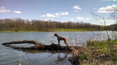
Johnson-Sauk Trail State Recreation Area is a 1,365-acre park in Henry County with rolling terrain, hardwood and pine forests, and open grasslands. A central 58-acre lake with roughly 2.5 miles of shoreline creates a focal point for the park.

Sauk, Fox, and Winnebago tribes built villages in this region and used local resources and trails that later became known as Sauk Trail. The park's name reflects this long indigenous presence.

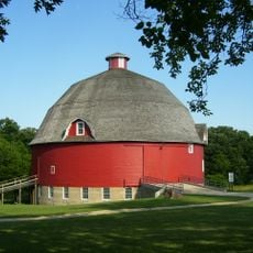
Ryan's Round Barn, built in 1910, sits within the park and shows how farmers once designed structures with its distinctive circular form. The building lets visitors connect with the agricultural practices that shaped this area.

The park opens and closes based on the season, with longer hours during warmer months. Visitors can plan for camping, boating, and hiking among the main activities available.

The park contains skunk cabbage plants that grow here in an uncommon way for this part of Illinois and even bloom during colder months. This makes it a special place for nature lovers interested in observing unusual plants.

The community of curious travelers

AroundUs brings together thousands of curated places, local tips, and hidden gems, enriched daily by 60,000 contributors worldwide.

Start exploring
Location
GPS coordinates
41.32140,-89.89030
Latest update
December 12, 2025 16:41
Around this place
Birthplace of Ronald Reagan
United States of America

Birthplace of Ronald Reagan

35.6 km
Hennepin Canal Parkway State Park
United States of America

Hennepin Canal Parkway State Park

17.8 km
H. C. Pitney Variety Store Building
United States of America

H. C. Pitney Variety Store Building

35.6 km
Bishop Hill Colony
United States of America

Bishop Hill Colony

23.4 km
Red Covered Bridge
United States of America

Red Covered Bridge

36 km
Bishop Hill State Historic Site
United States of America

Bishop Hill State Historic Site

23.4 km
Ryan Round Barn
United States of America

Ryan Round Barn

9.4 km
Main Street Historic District
United States of America

Main Street Historic District

35.6 km
Jenny Lind Chapel
United States of America

Jenny Lind Chapel

34.3 km
Frederick Francis Woodland Palace
United States of America

Frederick Francis Woodland Palace

5.4 km
Henry County Courthouse
United States of America

Henry County Courthouse

25.7 km
Old Danish Church
United States of America

Old Danish Church

13.6 km
Olof Johnson House
United States of America

Olof Johnson House

21.4 km
Village Hall
United States of America

Village Hall

13.4 km
Hampshire Colony Congregational Church
United States of America

Hampshire Colony Congregational Church

36.1 km
Greenwood Cottage
United States of America

Greenwood Cottage

36.7 km
Stevens House
United States of America

Stevens House

32.3 km
Kewanee Public Library
United States of America

Kewanee Public Library

9 km
Galva Opera House
United States of America

Galva Opera House

21.5 km
South Side School
United States of America

South Side School

26.7 km
Princeton Chapter House
United States of America

Princeton Chapter House

36.3 km
Annawan Chapter House
United States of America

Annawan Chapter House

10.2 km
First State Bank of Manlius
United States of America

First State Bank of Manlius

23.8 km
Atkinson Hall
United States of America

Atkinson Hall

26.3 km
Princeton North Main Street Historic District
United States of America

Princeton North Main Street Historic District

36.2 km
Andover Chapter House
United States of America

Andover Chapter House

33.7 km
Colonel George H. Paddock House
United States of America

Colonel George H. Paddock House

35.9 km
Princeton South Main Street-Courthouse Square Historic District
United States of America

Princeton South Main Street-Courthouse Square Historic District

35.9 km
Show the full map
« Johnson-Sauk Trail State Recreation Area - State recreation area in Henry County, Illinois, US » is provided by Around Us (aroundus.com). Images and texts are derived from Wikimedia project under a Creative Commons license. You are allowed to copy, distribute, and modify copies of this page, under the conditions set by the license, as long as this note is clearly visible.

Discover hidden gems everywhere you go!

From secret cafés to breathtaking viewpoints, skip the crowded tourist spots and find places that match your style. Our app makes it easy with voice search, smart filtering, route optimization, and insider tips from travelers worldwide. Download now for the complete mobile experience.

Around Us App Screenshot

A unique approach to discovering new places

Le Figaro

All the places worth exploring

France Info

A tailor-made excursion in just a few clicks

20 Minutes

Around Us
Travel Guide & Maps
Download

Send to your phone

QR Code
1

Open the camera app on your mobile.

2

Point at the QR code with your camera. A notification will appear.

3

Tap the notification to open the link.