Chest opened
+${chestReward.xp} XP
Explorer
NOUVEAU ×${chestReward.collectible.quantity}
tapez pour fermer
Chest locked

Open chests in the app

Around Us is built for your phone — chests unlock when you walk, explore and capture nearby places.

Enable Location

We need your location to show you interesting places around you

Discover nearby places

Find interesting locations and hidden gems around you

Precise directions

Get accurate directions and distances to places

Your location is never shared with other users. It's only used when you tap the location button.

Log in to your account

Start exploring — it's free

Trusted by 72,984 travelers worldwide

Continue with Google
Continue with Apple
or

We will send you a code to connect

By continuing, you accept our Terms and Conditions and our Privacy Policy

Check your inbox

We've sent a pincode in your inbox. Please enter the code below.

Kankakee Belt Route
Discussion Reviews Photo
2.8k Popularity

Kankakee Belt Route, Historical railroad route in northern Illinois, United States.

The Kankakee Belt Route is a railroad line that runs from South Bend, Indiana, through Kankakee, Illinois, and continues westward to Zearing, Illinois, running parallel to the Illinois River. The line spans across multiple states and connects various communities along its path.

The line was established in 1906 as part of the Chicago, Indiana and Southern Railroad, bringing together routes from the Indiana, Illinois & Iowa and Danville and Indiana Harbor Railroads. This merger of earlier rail lines created an important regional connection.

The railroad earned the nickname '3 I Line' from its corporate predecessor, the Indiana, Illinois & Iowa Railroad, reflecting its regional connection role.

Norfolk Southern operates the line today with multiple trains daily, offering an alternative route to bypass the congested rail yards around Chicago. The line is primarily used for freight transportation.

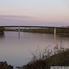
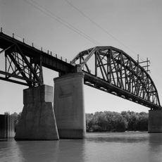
A swing bridge that crossed the Illinois River at DePue was struck by a barge in the early 1980s and later removed. This incident marked the end of this notable engineering structure.

The community of curious travelers

AroundUs brings together thousands of curated places, local tips, and hidden gems, enriched daily by 60,000 contributors worldwide.

Start exploring
Location
GPS coordinates
41.31410,-89.27860
Latest update
December 12, 2025 14:25
Around this place
Hegeler Carus Mansion
United States of America

Hegeler Carus Mansion

16.2 km
Dixon Waterfowl Refuge
United States of America

Dixon Waterfowl Refuge

11.6 km
United States of America

Donnelley/DePue State Fish and Wildlife Areas

5.2 km
Owen Lovejoy House
United States of America

Owen Lovejoy House

15.8 km
Hotel Kaskaskia
United States of America

Hotel Kaskaskia

15.4 km
Julius W. Hegeler I House
United States of America

Julius W. Hegeler I House

16.2 km
Shippingsport Bridge
United States of America

Shippingsport Bridge

15.6 km
Princeton Public Library, Illinois
United States of America

Princeton Public Library, Illinois

15.8 km
Putnam County Courthouse
United States of America

Putnam County Courthouse

8.7 km
Hampshire Colony Congregational Church
United States of America

Hampshire Colony Congregational Church

16.6 km
Greenwood Cottage
United States of America

Greenwood Cottage

16.2 km
Edward Pulsifer House
United States of America

Edward Pulsifer House

8.2 km
Richard M. Skinner House
United States of America

Richard M. Skinner House

16 km
LaSalle City Building
United States of America

LaSalle City Building

15.5 km
Colonel George H. Paddock House
United States of America

Colonel George H. Paddock House

16.6 km
Princeton South Main Street-Courthouse Square Historic District
United States of America

Princeton South Main Street-Courthouse Square Historic District

16.7 km
LaSalle Downtown Commercial District
United States of America

LaSalle Downtown Commercial District

15.3 km
United States of America

Abbaye Saint-Bède

9.3 km
LaSalle Rail Bridge
United States of America

LaSalle Rail Bridge

16.4 km
United States of America

Donnelley State Fish and Wildlife Area

5.2 km
United States of America

Spring Creek Golf Club

9.1 km
United States of America

South Bluff Country Club

13.2 km
United States of America

Stage 212

15.4 km
United States of America

Waterfall

14 km
United States of America

Waterfall

8.7 km
United States of America

Waterfall

8 km
United States of America

Waterfall

11.5 km
United States of America

Waterfall

16.4 km
Show the full map
Reviews
Share your experience

No review yet

Discussions
Start a discussion...

No discussion yet

« Kankakee Belt Route - Historical railroad route in northern Illinois, United States » is provided by Around Us (aroundus.com). Images and texts are derived from Wikimedia project under a Creative Commons license. You are allowed to copy, distribute, and modify copies of this page, under the conditions set by the license, as long as this note is clearly visible.

Discover hidden gems everywhere you go!

From secret cafés to breathtaking viewpoints, skip the crowded tourist spots and find places that match your style. Our app makes it easy with voice search, smart filtering, route optimization, and insider tips from travelers worldwide. Download now for the complete mobile experience.

Around Us App Screenshot

A unique approach to discovering new places

Le Figaro

All the places worth exploring

France Info

A tailor-made excursion in just a few clicks

20 Minutes

Around Us
Travel Guide & Maps
Download

Send to your phone

QR Code
1

Open the camera app on your mobile.

2

Point at the QR code with your camera. A notification will appear.

3

Tap the notification to open the link.