Lynchburg Covered Bridge

Log in to your account

AroundUs is a community-driven map of interesting places, built by curious explorers like you. It grows with every review, story, and photo you share.
Connect to save your favorite spots, contribute locations, and create personalized routes.
Continue with Google
Continue with Apple
Continue with X
Continue with Facebook
Continue with email
By continuing, you accept our Terms and Conditions and our Privacy Policy
Create an account
Add to collection
Map
Suggest a change
Share

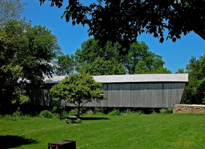
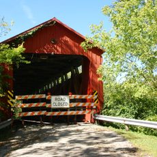
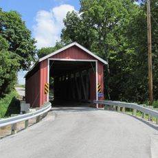
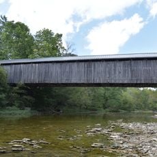
Lynchburg Covered Bridge, Covered bridge in Highland County, Ohio.

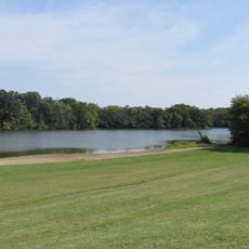
Lynchburg Covered Bridge is a wooden structure spanning the East Fork of the Little Miami River, built using a long truss design with a gabled roof for protection. The wooden frame sits on stone supports and shows the typical construction style of rural 19th-century American bridges.

Built in 1870, this bridge served as a transportation link across the river for nearly a century until it was retired from regular traffic in 1969. Its long service ended when modern roads bypassed the need for the crossing at this location.

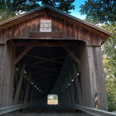
The bridge displays 19th-century American craftsmanship through its wooden joints and arched design, reflecting construction methods that were common in rural Ohio during that era. This craftsmanship remains visible in every detail you see when walking through it.

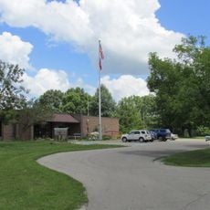
The bridge is open to visitors year-round and sits within a park where parking is available for easy access and photography. Early morning or late afternoon offers better light and fewer crowds for exploring and taking pictures.

During its restoration, structural modifications were made that set it apart from other historic covered bridges of its era. These changes demonstrate how traditional structures can be adapted to meet current safety and preservation standards.

Location: Ohio

GPS coordinates: 39.24500,-83.79444

Latest update: December 14, 2025 16:47

Photos
Around this place
Caesar Creek State Park
United States of America

Caesar Creek State Park

36.2 km
Fort Ancient
United States of America

Fort Ancient

31.3 km
Jeremiah Morrow Bridge
United States of America

Jeremiah Morrow Bridge

33 km
East Fork State Park
United States of America

East Fork State Park

37.3 km
Murphy Theatre
United States of America

Murphy Theatre

22.5 km
Rocky Fork State Park
United States of America

Rocky Fork State Park

28.5 km
Cowan Lake State Park
United States of America

Cowan Lake State Park

18.6 km
Paint Creek State Park
United States of America

Paint Creek State Park

34.9 km
Stonelick State Park
United States of America

Stonelick State Park

23.9 km
Cowan Lake
United States of America

Cowan Lake

18.1 km
Stonelick Covered Bridge
United States of America

Stonelick Covered Bridge

36.2 km
Wilmington Public Library of Clinton County, Ohio
United States of America

Wilmington Public Library of Clinton County, Ohio

22.9 km
Beam Farm Woodland Archaeological District
United States of America

Beam Farm Woodland Archaeological District

27.9 km
Keiter Mound
United States of America

Keiter Mound

34.5 km
Rocky Fork Park Site
United States of America

Rocky Fork Park Site

25.8 km
Highland County Courthouse
United States of America

Highland County Courthouse

16.4 km
Williams Stadium
United States of America

Williams Stadium

21.8 km
Hillside Haven Mound
United States of America

Hillside Haven Mound

26.7 km
Samuel Smith House and Tannery
United States of America

Samuel Smith House and Tannery

37.7 km
Cowan Creek Circular Enclosure
United States of America

Cowan Creek Circular Enclosure

19 km
Doan House
United States of America

Doan House

22.3 km
Martinsville Road Covered Bridge
United States of America

Martinsville Road Covered Bridge

10.1 km
McCafferty Road Covered Bridge
United States of America

McCafferty Road Covered Bridge

20.2 km
Moar Mound and Village Site
United States of America

Moar Mound and Village Site

37 km
Kim’s Classic Diner
United States of America

Kim’s Classic Diner

30.1 km
Milton Caniff
United States of America

Milton Caniff

15.6 km
New Hope Covered Bridge
United States of America

New Hope Covered Bridge

33.5 km
Caesar Creek Lake
United States of America

Caesar Creek Lake

28.3 km
Show the full map
Reviews

Visited this place? Tap the stars to rate it and share your experience / photos with the community! Try now! You can cancel it anytime.

« Lynchburg Covered Bridge - Covered bridge in Highland County, Ohio » is provided by Around Us (aroundus.com). Images and texts are derived from Wikimedia project under a Creative Commons license. You are allowed to copy, distribute, and modify copies of this page, under the conditions set by the license, as long as this note is clearly visible.

Discover hidden gems everywhere you go!

From secret cafés to breathtaking viewpoints, skip the crowded tourist spots and find places that match your style. Our app makes it easy with voice search, smart filtering, route optimization, and insider tips from travelers worldwide. Download now for the complete mobile experience.

Around Us App Screenshot

A unique approach to discovering new places

Le Figaro

All the places worth exploring

France Info

A tailor-made excursion in just a few clicks

20 Minutes