Enable Location

We need your location to show you interesting places around you

Discover nearby places

Find interesting locations and hidden gems around you

Precise directions

Get accurate directions and distances to places

Your location is never shared with other users. It's only used when you tap the location button.

Manchester Bridge

Log in to your account

Start exploring — it's free

Trusted by 62,492 travelers worldwide

Continue with Google
Continue with Apple
or

We will send you a code to connect

By continuing, you accept our Terms and Conditions and our Privacy Policy

Check your inbox

We've sent a pincode in your inbox. Please enter the code below.

Manchester Bridge

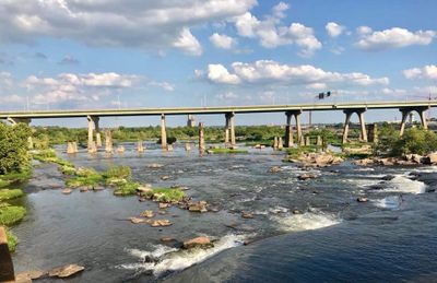
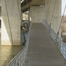
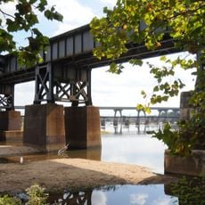
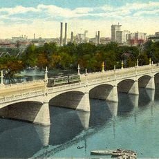
Manchester Bridge, Road bridge in Richmond, United States.

Manchester Bridge is a road bridge that spans the James River in Richmond, connecting downtown with the Southside district via U.S. Route 60. The structure includes a central pedestrian walkway alongside the vehicle lanes, allowing foot traffic across the river.

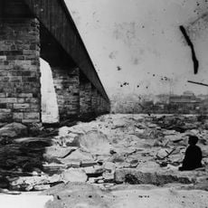
The bridge was completed in 1972 as a replacement after hurricanes damaged the former Ninth Street Bridge beyond repair. Its construction marked a new phase in connecting the two sides of the river after natural disaster.

The bridge provides a direct walking route for residents traveling between downtown and the Southside, shaped by a historical agreement that prioritized foot traffic alongside vehicle movement. People still use the central walkway today as an everyday path across the river.

The pedestrian walkway is free and accessible daily for foot traffic across the river. Its elevated design protects the crossing from flooding, making it usable in all weather conditions.

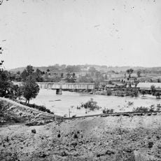
The predecessor bridge produced a distinctive humming sound from its wooden deck when vehicles crossed it. This acoustic quality earned it the nickname "Singing Bridge" among locals who still recall the feature.

The community of curious travelers

AroundUs brings together thousands of curated places, local tips, and hidden gems, enriched daily by 60,000 contributors worldwide.

Start exploring
Location
Inception
1972
Official opening
1972
GPS coordinates
37.53170,-77.44310
Latest update
December 12, 2025 12:05
Around this place
Virginia State Capitol
United States of America

Virginia State Capitol

1.2 km

Washington Monument
United States of America

Washington Monument

1.1 km
Virginia Civil Rights Memorial
United States of America

Virginia Civil Rights Memorial

1.2 km
Robert E. Lee Memorial Bridge
United States of America

Robert E. Lee Memorial Bridge

683 m
Stewart-Lee House
United States of America

Stewart-Lee House

1 km
First National Bank Building
United States of America

First National Bank Building

898 m
Barret House
United States of America

Barret House

885 m
Second Presbyterian Church
United States of America

Second Presbyterian Church

1 km
SunTrust Plaza
United States of America

SunTrust Plaza

919 m
Hull Street Station
United States of America

Hull Street Station

805 m
Richmond and Petersburg Railroad Bridge
United States of America

Richmond and Petersburg Railroad Bridge

53 m
Belle Isle railroad bridge
United States of America

Belle Isle railroad bridge

925 m
Triple Crossing
United States of America

Triple Crossing

1 km
Henry Coalter Cabell House
United States of America

Henry Coalter Cabell House

892 m
Main Street Banking Historic District
United States of America

Main Street Banking Historic District

926 m
Rivanna Subdivision Trestle
United States of America

Rivanna Subdivision Trestle

375 m
Virginia Mutual Building
United States of America

Virginia Mutual Building

898 m
George Washington Building
United States of America

George Washington Building

1.1 km
Samuel Pleasants Parsons House
United States of America

Samuel Pleasants Parsons House

1 km
Hancock-Wirt-Caskie House
United States of America

Hancock-Wirt-Caskie House

989 m
Richmond Tobacco Exchange
United States of America

Richmond Tobacco Exchange

964 m
Young Women's Christian Association
United States of America

Young Women's Christian Association

1 km
Planters National Bank
United States of America

Planters National Bank

966 m
St. Alban's Hall
United States of America

St. Alban's Hall

1.1 km
Tradegar Iron Works
United States of America

Tradegar Iron Works

474 m
Mayo Bridge
United States of America

Mayo Bridge

838 m
Civil War Visitor Center
United States of America

Civil War Visitor Center

475 m
Show the full map
« Manchester Bridge - Road bridge in Richmond, United States » is provided by Around Us (aroundus.com). Images and texts are derived from Wikimedia project under a Creative Commons license. You are allowed to copy, distribute, and modify copies of this page, under the conditions set by the license, as long as this note is clearly visible.

Discover hidden gems everywhere you go!

From secret cafés to breathtaking viewpoints, skip the crowded tourist spots and find places that match your style. Our app makes it easy with voice search, smart filtering, route optimization, and insider tips from travelers worldwide. Download now for the complete mobile experience.

Around Us App Screenshot

A unique approach to discovering new places

Le Figaro

All the places worth exploring

France Info

A tailor-made excursion in just a few clicks

20 Minutes

Around Us
Travel Guide & Maps
Download

Send to your phone

QR Code
1

Open the camera app on your mobile.

2

Point at the QR code with your camera. A notification will appear.

3

Tap the notification to open the link.