Enable Location

We need your location to show you interesting places around you

Discover nearby places

Find interesting locations and hidden gems around you

Precise directions

Get accurate directions and distances to places

Your location is never shared with other users. It's only used when you tap the location button.

Robert E. Lee Memorial Bridge

Log in to your account

Start exploring — it's free

Trusted by 62,492 travelers worldwide

Continue with Google
Continue with Apple
or

We will send you a code to connect

By continuing, you accept our Terms and Conditions and our Privacy Policy

Check your inbox

We've sent a pincode in your inbox. Please enter the code below.

Robert E. Lee Memorial Bridge

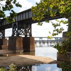
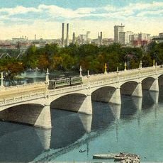
Robert E. Lee Memorial Bridge, Road bridge in Richmond, Virginia.

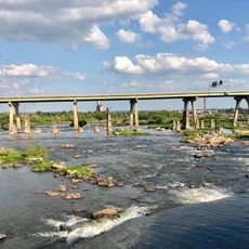
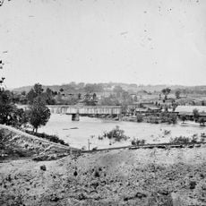
The Robert E. Lee Memorial Bridge is a road bridge carrying U.S. Route 1 and U.S. Route 301 across the James River in Richmond. Its six-lane structure provides direct vehicle passage from north to south across the waterway.

The structure was originally built in 1934 as a four-lane toll bridge and underwent complete reconstruction during the 1980s, completed in 1989. This major rebuilding transformed it to meet the city's growing transportation demands.

The bridge became the subject of community discussions starting in 2020, reflecting how cities reconsider their public symbols and historical naming. Local conversations about what the structure represents continue to shape how people think about the space.

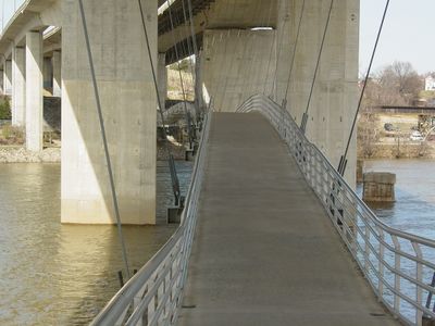
The bridge provides free passage with three lanes in each direction and is open daily to traffic. A pedestrian footbridge beneath the road deck connects Tredegar Street to Belle Isle for those on foot.

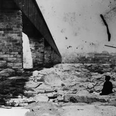
A hidden feature is the pedestrian path running beneath the main roadway that directly connects Belle Isle in the river to the city. Most drivers crossing above never notice this covered passage below them.

The community of curious travelers

AroundUs brings together thousands of curated places, local tips, and hidden gems, enriched daily by 60,000 contributors worldwide.

Start exploring
Location
GPS coordinates
37.53020,-77.45060
Latest update
December 10, 2025 20:06
Around this place
Hollywood Cemetery
United States of America

Hollywood Cemetery

945 m

Virginia War Memorial
United States of America

Virginia War Memorial

766 m
Manchester Bridge
United States of America

Manchester Bridge

683 m
Stewart-Lee House
United States of America

Stewart-Lee House

1.6 km
First National Bank Building
United States of America

First National Bank Building

1.5 km
Barret House
United States of America

Barret House

1.4 km
Bolling Haxall House
United States of America

Bolling Haxall House

1.6 km
Second Presbyterian Church
United States of America

Second Presbyterian Church

1.5 km
Ellen Glasgow House
United States of America

Ellen Glasgow House

1.5 km
SunTrust Plaza
United States of America

SunTrust Plaza

1.5 km
St. Andrew's Church
United States of America

St. Andrew's Church

1.4 km
Hull Street Station
United States of America

Hull Street Station

1.3 km
Richmond and Petersburg Railroad Bridge
United States of America

Richmond and Petersburg Railroad Bridge

647 m
Crozet House
United States of America

Crozet House

1.5 km
Belle Isle railroad bridge
United States of America

Belle Isle railroad bridge

275 m
Block 0-100 East Franklin Street Historic District
United States of America

Block 0-100 East Franklin Street Historic District

1.6 km
Henry Coalter Cabell House
United States of America

Henry Coalter Cabell House

1.2 km
Main Street Banking Historic District
United States of America

Main Street Banking Historic District

1.5 km
Rivanna Subdivision Trestle
United States of America

Rivanna Subdivision Trestle

1.1 km
Virginia Mutual Building
United States of America

Virginia Mutual Building

1.5 km
Samuel Pleasants Parsons House
United States of America

Samuel Pleasants Parsons House

982 m
Hancock-Wirt-Caskie House
United States of America

Hancock-Wirt-Caskie House

1.4 km
Young Women's Christian Association
United States of America

Young Women's Christian Association

1.5 km
St. Alban's Hall
United States of America

St. Alban's Hall

1.5 km
Tradegar Iron Works
United States of America

Tradegar Iron Works

714 m
James Monroe Tomb
United States of America

James Monroe Tomb

655 m
Mayo Bridge
United States of America

Mayo Bridge

1.5 km
Show the full map
« Robert E. Lee Memorial Bridge - Road bridge in Richmond, Virginia » is provided by Around Us (aroundus.com). Images and texts are derived from Wikimedia project under a Creative Commons license. You are allowed to copy, distribute, and modify copies of this page, under the conditions set by the license, as long as this note is clearly visible.

Discover hidden gems everywhere you go!

From secret cafés to breathtaking viewpoints, skip the crowded tourist spots and find places that match your style. Our app makes it easy with voice search, smart filtering, route optimization, and insider tips from travelers worldwide. Download now for the complete mobile experience.

Around Us App Screenshot

A unique approach to discovering new places

Le Figaro

All the places worth exploring

France Info

A tailor-made excursion in just a few clicks

20 Minutes

Around Us
Travel Guide & Maps
Download

Send to your phone

QR Code
1

Open the camera app on your mobile.

2

Point at the QR code with your camera. A notification will appear.

3

Tap the notification to open the link.