Enable Location

We need your location to show you interesting places around you

Discover nearby places

Find interesting locations and hidden gems around you

Precise directions

Get accurate directions and distances to places

Your location is never shared with other users. It's only used when you tap the location button.

Mt. Pisgah State Park

Log in to your account

Start exploring — it's free

Trusted by 61,364 travelers worldwide

Continue with Google
Continue with Apple
or

We will send you a code to connect

By continuing, you accept our Terms and Conditions and our Privacy Policy

Check your inbox

We've sent a pincode in your inbox. Please enter the code below.

Mt. Pisgah State Park

Mt. Pisgah State Park, State park in Bradford County, United States.

Description

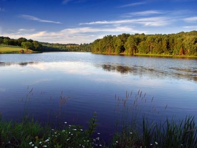
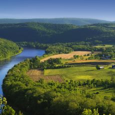
Mt. Pisgah State Park is a state park in Pennsylvania covering approximately 1,302 acres with forests, open fields, and Stephen Foster Lake at its center. The property spans across multiple townships and offers diverse natural settings for exploration and recreation.

History

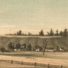
The land that forms the park today was previously used for agriculture before the Commonwealth of Pennsylvania acquired it in 1969. The site later developed into a public recreation area, opening its facilities to visitors in 1979.

Culture

The park serves as a gathering place where people come to experience outdoor recreation and connect with the natural landscape of the region. Visitors use the trails and lakeside areas as everyday spaces for walking, observing wildlife, and spending time away from busy areas.

Practical

The lake allows both electric and non-powered boats, making it accessible to different visitors interested in water activities and fishing. Parts of the park are designated hunting areas during certain seasons, so plan visits accordingly if you prefer to avoid those times.

Did you know?

The park contains over 1,100 acres designated for hunting where visitors can pursue ruffed grouse, squirrels, deer, and other game under state regulations. This large hunting area sets it apart as a destination for people interested in this type of outdoor activity.

Location
Inception
1979
GPS coordinates
41.80830,-76.66810
Latest update
December 9, 2025 18:44

AroundUs brings together thousands of curated places, local tips, and hidden gems, enriched daily by 60,000 contributors worldwide. Discover all places nearby (Bradford County).

Around this place
French Azilum
United States of America

French Azilum

30.2 km
Newtown Battlefield State Park
United States of America

Newtown Battlefield State Park

26.9 km
Spanish Hill
United States of America

Spanish Hill

23 km
Phillip Paul Bliss House
United States of America

Phillip Paul Bliss House

27.6 km
Chemung County Historical Society
United States of America

Chemung County Historical Society

33.1 km
F. M. Howell and Company
United States of America

F. M. Howell and Company

32.9 km
Chemung Canal Bank Building
United States of America

Chemung Canal Bank Building

33 km
Bradford County Courthouse
United States of America

Bradford County Courthouse

19.6 km
Methodist Episcopal Church of Burlington
United States of America

Methodist Episcopal Church of Burlington

4.9 km
Protection of the Flag Monument
United States of America

Protection of the Flag Monument

20.2 km
Waverly Village Hall
United States of America

Waverly Village Hall

23.9 km
John Brand Jr. House
United States of America

John Brand Jr. House

32.6 km
Alexander Eustace House
United States of America

Alexander Eustace House

32.5 km
Sunbury Historic District
United States of America

Sunbury Historic District

12 km
Athens Historic District
United States of America

Athens Historic District

20.2 km
Spalding Memorial Library-Tioga Point Museum
United States of America

Spalding Memorial Library-Tioga Point Museum

20.3 km
John Brand Sr. House
United States of America

John Brand Sr. House

32.5 km
Towanda Historic District
United States of America

Towanda Historic District

18.8 km
Universalist Meeting House of Sheshequin
United States of America

Universalist Meeting House of Sheshequin

15.8 km
United States Post Office (Waverly, New York)
United States of America

United States Post Office (Waverly, New York)

24 km
Christ Episcopal Church
United States of America

Christ Episcopal Church

23.5 km
Bridge in Athens Township
United States of America

Bridge in Athens Township

21 km
Van Dyne Civic Building
United States of America

Van Dyne Civic Building

10.1 km
Dr. Hovey Everett House
United States of America

Dr. Hovey Everett House

29.1 km
Chemung District School No. 10
United States of America

Chemung District School No. 10

24.9 km
Chemung Valley History Museum
United States of America

Chemung Valley History Museum

33.1 km
Knapp's Covered Bridge
United States of America

Knapp's Covered Bridge

9.8 km
Keystone Theatre
United States of America

Keystone Theatre

19.5 km
Show the full map
« Mt. Pisgah State Park - State park in Bradford County, United States » is provided by Around Us (aroundus.com). Images and texts are derived from Wikimedia project under a Creative Commons license. You are allowed to copy, distribute, and modify copies of this page, under the conditions set by the license, as long as this note is clearly visible.

Discover hidden gems everywhere you go!

From secret cafés to breathtaking viewpoints, skip the crowded tourist spots and find places that match your style. Our app makes it easy with voice search, smart filtering, route optimization, and insider tips from travelers worldwide. Download now for the complete mobile experience.

Around Us App Screenshot

A unique approach to discovering new places

Le Figaro

All the places worth exploring

France Info

A tailor-made excursion in just a few clicks

20 Minutes

Around Us
Travel Guide & Maps
Download

Send to your phone

QR Code
1

Open the camera app on your mobile.

2

Point at the QR code with your camera. A notification will appear.

3

Tap the notification to open the link.