Enable Location

We need your location to show you interesting places around you

Discover nearby places

Find interesting locations and hidden gems around you

Precise directions

Get accurate directions and distances to places

Your location is never shared with other users. It's only used when you tap the location button.

Morgan Covered Bridge

Log in to your account

Start exploring — it's free

Trusted by 61,897 travelers worldwide

Continue with Google
Continue with Apple
or

We will send you a code to connect

By continuing, you accept our Terms and Conditions and our Privacy Policy

Check your inbox

We've sent a pincode in your inbox. Please enter the code below.

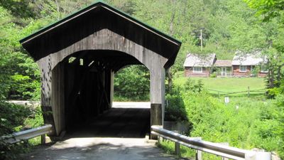
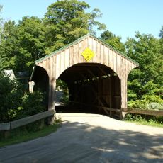
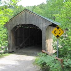
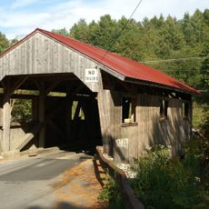
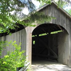
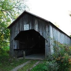
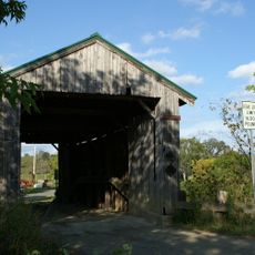
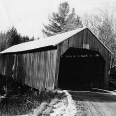
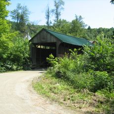
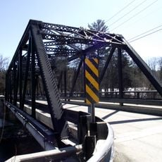
Morgan Covered Bridge, Covered bridge in Belvidere, US

Morgan Covered Bridge is a wooden crossing over the North Branch Lamoille River in Belvidere that spans the water with a single arch-like structure. The building has vertical wooden boards on its sides and an interior braced with angled wooden supports.

This structure was built in 1887 by Lewis Robinson, Charles Leonard, and Fred Tracy as part of late 1800s construction work in the region. It gained official recognition in 1974 when it was added to the National Register of Historic Places.

This crossing shows Vermont's building tradition with its wood construction and distinctive arched portals. You can see how such structures were made to last through harsh winters and constant river flow.

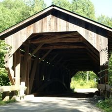
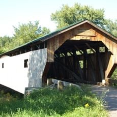
You can visit during daytime when the crossing is open, and it is easy to view the structure from either bank or walk along the side. The interior reinforcement added in 1971 keeps it safe for regular use by vehicles and pedestrians.

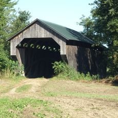
It is part of a group of five similar structures built across the same river within a short distance, making this area unusual for its concentration of old wooden crossings. This gathering of bridges in one place is rare and draws people interested in old construction methods.

The community of curious travelers

AroundUs brings together thousands of curated places, local tips, and hidden gems, enriched daily by 60,000 contributors worldwide.

Start exploring
Location
GPS coordinates
44.74333,-72.72778
Latest update
December 14, 2025 17:43
Around this place
Chester Alan Arthur State Historic Site
United States of America

Chester Alan Arthur State Historic Site

18 km
Gates Farm Covered Bridge
United States of America

Gates Farm Covered Bridge

15.8 km
Grist Mill Covered Bridge
United States of America

Grist Mill Covered Bridge

14.1 km
Church Street Covered Bridge
United States of America

Church Street Covered Bridge

6.8 km
Poland Covered Bridge
United States of America

Poland Covered Bridge

12.3 km
Hutchins Covered Bridge
United States of America

Hutchins Covered Bridge

15.7 km
West Hill Covered Bridge
United States of America

West Hill Covered Bridge

15.2 km
Montgomery Covered Bridge
United States of America

Montgomery Covered Bridge

6.2 km
Enosburg Congregational Memorial Church
United States of America

Enosburg Congregational Memorial Church

15.7 km
Comstock Covered Bridge
United States of America

Comstock Covered Bridge

18.6 km
Fuller Covered Bridge
United States of America

Fuller Covered Bridge

19.1 km
Cambridge Meetinghouse
United States of America

Cambridge Meetinghouse

13.8 km
Power House Covered Bridge
United States of America

Power House Covered Bridge

12.8 km
Mill Covered Bridge
United States of America

Mill Covered Bridge

1 km
East Fairfield Covered Bridge
United States of America

East Fairfield Covered Bridge

11.6 km
St. George's Catholic Church
United States of America

St. George's Catholic Church

7.1 km
Scribner Covered Bridge
United States of America

Scribner Covered Bridge

13.3 km
Jeffersonville Bridge
United States of America

Jeffersonville Bridge

13.3 km
Hectorville Covered Bridge
United States of America

Hectorville Covered Bridge

15.2 km
Fletcher Union Church
United States of America

Fletcher Union Church

16 km
Waterman Covered Bridge
United States of America

Waterman Covered Bridge

15.3 km
Nye Block
United States of America

Nye Block

12.6 km
Lamoille County Courthouse
United States of America

Lamoille County Courthouse

18.9 km
Jaynes Covered Bridge
United States of America

Jaynes Covered Bridge

4.2 km
Montgomery House
United States of America

Montgomery House

18.9 km
Bridge 6
United States of America

Bridge 6

12.6 km
Waterville Village Historic District
United States of America

Waterville Village Historic District

6.8 km
Jeffersonville Historic District
United States of America

Jeffersonville Historic District

13.5 km
Show the full map
« Morgan Covered Bridge - Covered bridge in Belvidere, US » is provided by Around Us (aroundus.com). Images and texts are derived from Wikimedia project under a Creative Commons license. You are allowed to copy, distribute, and modify copies of this page, under the conditions set by the license, as long as this note is clearly visible.

Discover hidden gems everywhere you go!

From secret cafés to breathtaking viewpoints, skip the crowded tourist spots and find places that match your style. Our app makes it easy with voice search, smart filtering, route optimization, and insider tips from travelers worldwide. Download now for the complete mobile experience.

Around Us App Screenshot

A unique approach to discovering new places

Le Figaro

All the places worth exploring

France Info

A tailor-made excursion in just a few clicks

20 Minutes

Around Us
Travel Guide & Maps
Download

Send to your phone

QR Code
1

Open the camera app on your mobile.

2

Point at the QR code with your camera. A notification will appear.

3

Tap the notification to open the link.