Enable Location

We need your location to show you interesting places around you

Discover nearby places

Find interesting locations and hidden gems around you

Precise directions

Get accurate directions and distances to places

Your location is never shared with other users. It's only used when you tap the location button.

Muscatatuck National Wildlife Refuge

Log in to your account

Start exploring — it's free

Trusted by 64,669 travelers worldwide

Continue with Google
Continue with Apple
or

We will send you a code to connect

By continuing, you accept our Terms and Conditions and our Privacy Policy

Check your inbox

We've sent a pincode in your inbox. Please enter the code below.

Muscatatuck National Wildlife Refuge
Discussion Reviews 1 Photos
4.4k Popularity

Muscatatuck National Wildlife Refuge, National Wildlife Refuge in Jackson County, Indiana.

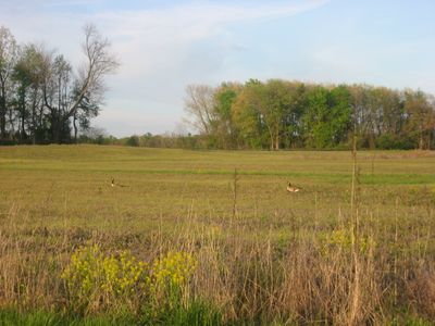
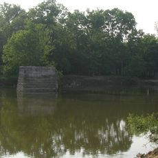
Muscatatuck National Wildlife Refuge is a federally protected area in southern Indiana, made up of wetlands, deciduous forests, and open farmland. The refuge sits in Jackson County and is crossed by the Muscatatuck River, which gives the place its name.

The refuge was established in 1966 as Indiana's first National Wildlife Refuge, funded by federal money set aside to protect waterfowl. The land had previously been used for farming and was gradually restored to natural habitats over the following decades.

The name Muscatatuck comes from a Native American language and roughly translates to 'land of winding waters,' which reflects the many streams and wetland areas found here. Visitors walking the trails today can still sense how the landscape is shaped by water at every turn.

The refuge has several hiking trails and a driving route that works well for wildlife watching, especially in the early morning or late afternoon. A visitor center near the entrance can help with orientation and provide tips on what to look for at the time of your visit.

In 1998, four trumpeter swans were brought to the refuge as part of a program to bring back a species that had disappeared from the region for many decades. Their descendants can still be spotted here today, making this one of the few places in Indiana where these birds now live.

The community of curious travelers

AroundUs brings together thousands of curated places, local tips, and hidden gems, enriched daily by 60,000 contributors worldwide.

Start exploring
Location
Inception
1966
GPS coordinates
38.93330,-85.80830
Latest update
March 3, 2026 08:13
Around this place
Muscatatuck Urban Training Center
United States of America

Muscatatuck Urban Training Center

27 km
Freeman Field Mutiny
United States of America

Freeman Field Mutiny

8.7 km
United States of America

New Albany Shale

27.6 km
Eleutherian College
United States of America

Eleutherian College

27.7 km
United States of America

The Republic Newspaper Office

31.3 km
Mabel McDowell Adult Education Center
United States of America

Mabel McDowell Adult Education Center

30.8 km
Bell Ford Covered Bridge
United States of America

Bell Ford Covered Bridge

11.4 km
United States of America

Stream Cliff Farm

17.3 km
Jackson County Courthouse
United States of America

Jackson County Courthouse

21.1 km
First Presbyterian Church
United States of America

First Presbyterian Church

7.8 km
Lyman and Asenath Hoyt House
United States of America

Lyman and Asenath Hoyt House

27.4 km
Shields' Mill Covered Bridge
United States of America

Shields' Mill Covered Bridge

16.9 km
Scott County Home
United States of America

Scott County Home

29.1 km
Scottsburg Courthouse Square Historic District
United States of America

Scottsburg Courthouse Square Historic District

27.8 km
Annadale
United States of America

Annadale

18.4 km
Bartholomew County Annex building
United States of America

Bartholomew County Annex building

30.4 km
Rising Sun Historic District
United States of America

Rising Sun Historic District

4.2 km
Farmers Club
United States of America

Farmers Club

7.5 km
George H. Vehslage House
United States of America

George H. Vehslage House

8 km
Seymour Commercial Historic District
United States of America

Seymour Commercial Historic District

7.5 km
T. Harlan and Helen Montgomery House
United States of America

T. Harlan and Helen Montgomery House

8.2 km
David Aikens House
United States of America

David Aikens House

28.8 km
Vernon Historic District
United States of America

Vernon Historic District

17.9 km
Tiemeyer's Farm Market Petting Zoo
United States of America

Tiemeyer's Farm Market Petting Zoo

27.1 km
Hayden Historical Museum
United States of America

Hayden Historical Museum

8.3 km
Robert N. Stewart Bridge
United States of America

Robert N. Stewart Bridge

31.2 km
James Covered Bridge
United States of America

James Covered Bridge

17.3 km
Clifty Creek Bridge
United States of America

Clifty Creek Bridge

27.9 km
Show the full map
Reviews
Share your experience

No review yet

Discussions
Start a discussion...

No discussion yet

« Muscatatuck National Wildlife Refuge - National Wildlife Refuge in Jackson County, Indiana » is provided by Around Us (aroundus.com). Images and texts are derived from Wikimedia project under a Creative Commons license. You are allowed to copy, distribute, and modify copies of this page, under the conditions set by the license, as long as this note is clearly visible.

Discover hidden gems everywhere you go!

From secret cafés to breathtaking viewpoints, skip the crowded tourist spots and find places that match your style. Our app makes it easy with voice search, smart filtering, route optimization, and insider tips from travelers worldwide. Download now for the complete mobile experience.

Around Us App Screenshot

A unique approach to discovering new places

Le Figaro

All the places worth exploring

France Info

A tailor-made excursion in just a few clicks

20 Minutes

Around Us
Travel Guide & Maps
Download

Send to your phone

QR Code
1

Open the camera app on your mobile.

2

Point at the QR code with your camera. A notification will appear.

3

Tap the notification to open the link.