·

Enable Location

We need your location to show you interesting places around you

Discover nearby places

Find interesting locations and hidden gems around you

Precise directions

Get accurate directions and distances to places

Your location is never shared with other users. It's only used when you tap the location button.

Bell Ford Covered Bridge

Log in to your account

Start exploring — it's free

Trusted by 62,700 travelers worldwide

Continue with Google
Continue with Apple
or

We will send you a code to connect

By continuing, you accept our Terms and Conditions and our Privacy Policy

Check your inbox

We've sent a pincode in your inbox. Please enter the code below.

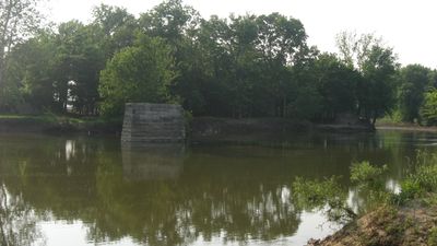
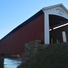
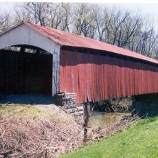
Bell Ford Covered Bridge, Covered bridge in Jackson County, US.

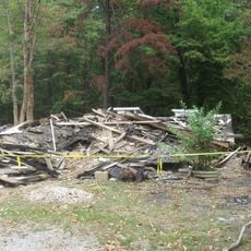
Bell Ford Covered Bridge was a wooden structure with iron reinforcements that crossed the East Fork White River on limestone foundations. The building was damaged in 1999 and again in 2006, leaving only the foundations and scattered structural remains today.

Built in 1885, this bridge emerged during a period when engineers began combining traditional wooden construction with new metal components. It reflected shifts in how rural communities were connected as transportation methods and materials evolved across Indiana.

The bridge stands as an example of nineteenth-century engineering methods, demonstrating the evolution of transportation infrastructure in rural Indiana communities.

Only the foundations remain visible at the original site, so visitors can see where the bridge once stood but cannot cross any structure. The location sits near the river, and access depends on local land conditions.

The original design used a Post Patented Diagonal construction method, a rare combination of wood and iron elements that made this the last bridge of its kind built this way. This specific building technique disappeared from use after this structure was completed.

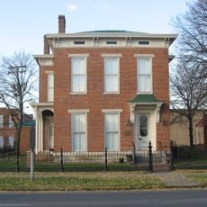
The community of curious travelers

AroundUs brings together thousands of curated places, local tips, and hidden gems, enriched daily by 60,000 contributors worldwide.

Start exploring
Location
Inception
1885
Made from material
limestone, iron, wood
GPS coordinates
38.97333,-85.92944
Latest update
December 14, 2025 09:45
Around this place
First Christian Church
United States of America

First Christian Church

25.6 km
Freeman Field Mutiny
United States of America

Freeman Field Mutiny

5.7 km
Muscatatuck National Wildlife Refuge
United States of America

Muscatatuck National Wildlife Refuge

11.4 km
Irwin Conference Center
United States of America

Irwin Conference Center

25.6 km
Medora Covered Bridge
United States of America

Medora Covered Bridge

25.6 km
Crump Theatre
United States of America

Crump Theatre

25.4 km
United States of America

The Republic Newspaper Office

25.2 km
Bartholomew County Courthouse
United States of America

Bartholomew County Courthouse

25.4 km
The Arch
United States of America

The Arch

25.7 km
Mabel McDowell Adult Education Center
United States of America

Mabel McDowell Adult Education Center

25.7 km
Jackson County Courthouse
United States of America

Jackson County Courthouse

14.3 km
Columbus Power House
United States of America

Columbus Power House

25.2 km
First Presbyterian Church
United States of America

First Presbyterian Church

3.6 km
Grandview Apostolic Church
United States of America

Grandview Apostolic Church

21.5 km
McEwen-Samuels-Marr House
United States of America

McEwen-Samuels-Marr House

25.4 km
Shields' Mill Covered Bridge
United States of America

Shields' Mill Covered Bridge

9 km
Columbus City Hall
United States of America

Columbus City Hall

25.6 km
Bartholomew County Annex building
United States of America

Bartholomew County Annex building

24.9 km
Rising Sun Historic District
United States of America

Rising Sun Historic District

7.2 km
Farmers Club
United States of America

Farmers Club

3.9 km
George H. Vehslage House
United States of America

George H. Vehslage House

3.4 km
Seymour Commercial Historic District
United States of America

Seymour Commercial Historic District

3.9 km
T. Harlan and Helen Montgomery House
United States of America

T. Harlan and Helen Montgomery House

3.2 km
David Aikens House
United States of America

David Aikens House

22.4 km
Tiemeyer's Farm Market Petting Zoo
United States of America

Tiemeyer's Farm Market Petting Zoo

21.2 km
Hayden Historical Museum
United States of America

Hayden Historical Museum

16.8 km
Robert N. Stewart Bridge
United States of America

Robert N. Stewart Bridge

25.1 km
Jonathan Moore Pike I-65 Bridge
United States of America

Jonathan Moore Pike I-65 Bridge

25.4 km
Show the full map
« Bell Ford Covered Bridge - Covered bridge in Jackson County, US » is provided by Around Us (aroundus.com). Images and texts are derived from Wikimedia project under a Creative Commons license. You are allowed to copy, distribute, and modify copies of this page, under the conditions set by the license, as long as this note is clearly visible.

Discover hidden gems everywhere you go!

From secret cafés to breathtaking viewpoints, skip the crowded tourist spots and find places that match your style. Our app makes it easy with voice search, smart filtering, route optimization, and insider tips from travelers worldwide. Download now for the complete mobile experience.

Around Us App Screenshot

A unique approach to discovering new places

Le Figaro

All the places worth exploring

France Info

A tailor-made excursion in just a few clicks

20 Minutes

Around Us
Travel Guide & Maps
Download

Send to your phone

QR Code
1

Open the camera app on your mobile.

2

Point at the QR code with your camera. A notification will appear.

3

Tap the notification to open the link.