Enable Location

We need your location to show you interesting places around you

Discover nearby places

Find interesting locations and hidden gems around you

Precise directions

Get accurate directions and distances to places

Your location is never shared with other users. It's only used when you tap the location button.

Bartholomew County Courthouse

Log in to your account

Start exploring — it's free

Trusted by 61,698 travelers worldwide

Continue with Google
Continue with Apple
or

We will send you a code to connect

By continuing, you accept our Terms and Conditions and our Privacy Policy

Check your inbox

We've sent a pincode in your inbox. Please enter the code below.

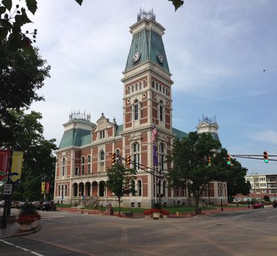
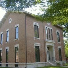
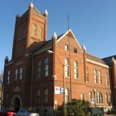
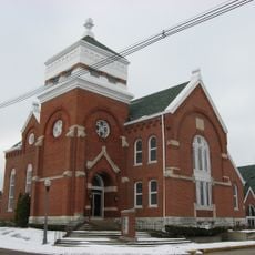
Bartholomew County Courthouse, County courthouse in Columbus, US.

Description

Bartholomew County Courthouse is a Second Empire building with red brick walls and limestone trim located in Columbus. It features corner pavilions, a mansard roof, and a six-story clock tower that rises 154 feet (47 meters) above the surrounding streets.

History

Construction took place between 1871 and 1874, with architect Isaac Hodgson designing the structure and builders McCormack and Sweeny overseeing the work. The building emerged during a period of growth in the region and reflected the county's need for a substantial administrative center.

Culture

The courthouse anchors the historic downtown area and shapes how people move through and perceive the city center. Its prominent position makes it a natural gathering point and visual reference that locals and visitors use to orient themselves.

Practical

The building sits at the intersection of 3rd and Washington Streets in the heart of downtown, making it easy to find and reach on foot. The open space around it allows you to see the structure from different angles and walk around the exterior at your own pace.

Did you know?

In 1940, a 900-pound weight fell from the clock mechanism, prompting a major overhaul of the system. The original weighted mechanism gave way to an electric motor, transforming how the clock operated.

Location
GPS coordinates
39.20111,-85.92139
Latest update
December 12, 2025 17:47

AroundUs brings together thousands of curated places, local tips, and hidden gems, enriched daily by 60,000 contributors worldwide. Discover all places nearby (Columbus).

Around this place
Camp Atterbury
United States of America

Camp Atterbury

14.3 km
Miller House and Garden
United States of America

Miller House and Garden

2.9 km
North Christian Church
United States of America

North Christian Church

3.2 km
First Christian Church
United States of America

First Christian Church

308 m
Cummins Corporate Office Building
United States of America

Cummins Corporate Office Building

599 m
Cleo Rogers Memorial Library
United States of America

Cleo Rogers Memorial Library

387 m
Irwin Conference Center
United States of America

Irwin Conference Center

277 m
Crump Theatre
United States of America

Crump Theatre

105 m
United States of America

The Republic Newspaper Office

134 m
United States of America

Mill Race Park

596 m
The Arch
United States of America

The Arch

374 m
Mabel McDowell Adult Education Center
United States of America

Mabel McDowell Adult Education Center

2.5 km
Columbus Power House
United States of America

Columbus Power House

360 m
Columbus Historic District
United States of America

Columbus Historic District

665 m
Grandview Apostolic Church
United States of America

Grandview Apostolic Church

16.5 km
McEwen-Samuels-Marr House
United States of America

McEwen-Samuels-Marr House

224 m
New Hope Bridge
United States of America

New Hope Bridge

6.5 km
Columbus City Hall
United States of America

Columbus City Hall

241 m
Brownsville Covered Bridge
United States of America

Brownsville Covered Bridge

938 m
Bartholomew County Annex building
United States of America

Bartholomew County Annex building

1.8 km
South Walnut Street Historic District
United States of America

South Walnut Street Historic District

17.2 km
Pugh Ford Bridge
United States of America

Pugh Ford Bridge

15.6 km
Toner Historic District
United States of America

Toner Historic District

17.4 km
David Aikens House
United States of America

David Aikens House

3.1 km
Robert N. Stewart Bridge
United States of America

Robert N. Stewart Bridge

434 m
Jonathan Moore Pike I-65 Bridge
United States of America

Jonathan Moore Pike I-65 Bridge

3.2 km
Clifty Creek Bridge
United States of America

Clifty Creek Bridge

4.4 km
New Brownsville Bridge
United States of America

New Brownsville Bridge

890 m
Show the full map
« Bartholomew County Courthouse - County courthouse in Columbus, US » is provided by Around Us (aroundus.com). Images and texts are derived from Wikimedia project under a Creative Commons license. You are allowed to copy, distribute, and modify copies of this page, under the conditions set by the license, as long as this note is clearly visible.

Discover hidden gems everywhere you go!

From secret cafés to breathtaking viewpoints, skip the crowded tourist spots and find places that match your style. Our app makes it easy with voice search, smart filtering, route optimization, and insider tips from travelers worldwide. Download now for the complete mobile experience.

Around Us App Screenshot

A unique approach to discovering new places

Le Figaro

All the places worth exploring

France Info

A tailor-made excursion in just a few clicks

20 Minutes

Around Us
Travel Guide & Maps
Download

Send to your phone

QR Code
1

Open the camera app on your mobile.

2

Point at the QR code with your camera. A notification will appear.

3

Tap the notification to open the link.