Norris Dam State Park

Log in to your account

AroundUs is a community-driven map of interesting places, built by curious explorers like you. It grows with every review, story, and photo you share.
Connect to save your favorite spots, contribute locations, and create personalized routes.
Continue with Google
Continue with Apple
Continue with X
Continue with Facebook
Continue with email
By continuing, you accept our Terms and Conditions and our Privacy Policy
Create an account
Add to collection
Map
Suggest a change
Share

Norris Dam State Park, State park in Anderson County and Campbell County, Tennessee

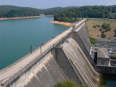
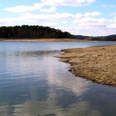
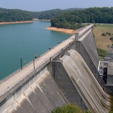
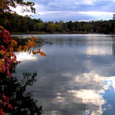
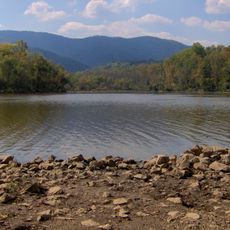
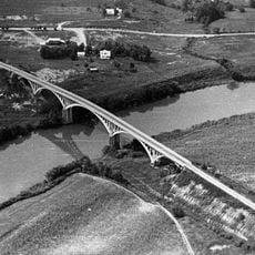
Norris Dam State Park spans 4,000 acres of wooded hills, lakes, and trails that run along the Clinch River and its shoreline. Two separate sections of the park sit on either side of the dam structure, which holds back the waters to form Norris Lake.

The dam was built during the 1930s under President Roosevelt's New Deal as a response to flooding and a way to generate electrical power for the region. This construction marked a major turning point in how the valley developed and grew.

The park serves as a place to learn about the Tennessee Valley Authority's role in shaping the region, with exhibits and guided walks that show how this program changed the landscape and local communities. Visitors can see firsthand how the dam became central to the area's identity and development.

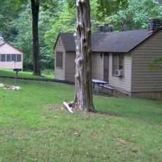
The park provides camping areas with RV hookups and tent sites, along with modern restrooms, picnic areas, and fire rings distributed throughout the grounds. Plan your visit during warmer months when the trails and waterside areas are most accessible and pleasant.

The park's two sections are connected only by the dam structure itself, creating an unusual layout where the two sides feel almost like separate destinations. Visitors can enjoy the lake and trails without necessarily crossing the dam or seeing it up close.

Location: Anderson County

Location: Campbell County

Inception: 1953

Website: https://tnstateparks.com/parks/norris-dam

GPS coordinates: 36.23960,-84.10940

Latest update: December 8, 2025 19:57

Photos
Around this place
Norris Lake
United States of America

Norris Lake

21.6 km
Norris Dam
United States of America

Norris Dam

2.4 km
Museum of Appalachia
United States of America

Museum of Appalachia

7.4 km
American Museum of Science and Energy
United States of America

American Museum of Science and Energy

28.4 km
Big Ridge State Park
United States of America

Big Ridge State Park

16.9 km
Cove Lake State Park
United States of America

Cove Lake State Park

12 km
Green McAdoo School
United States of America

Green McAdoo School

15.5 km
United Church, The Chapel on the Hill
United States of America

United Church, The Chapel on the Hill

26.2 km
Alexander Inn
United States of America

Alexander Inn

26.3 km
LaFollette House
United States of America

LaFollette House

16.1 km
Children's Museum of Oak Ridge
United States of America

Children's Museum of Oak Ridge

28.2 km
Alexander Bishop House
United States of America

Alexander Bishop House

22.2 km
United States of America

Fort Adair

28.9 km
Savage House and Garden
United States of America

Savage House and Garden

27.5 km
Oak Ridge Historic District
United States of America

Oak Ridge Historic District

26.8 km
Kincaid-Howard House
United States of America

Kincaid-Howard House

19.6 km
Luther Brannon House
United States of America

Luther Brannon House

23.5 km
J. B. Jones House
United States of America

J. B. Jones House

26.2 km
A.E. Perkins House
United States of America

A.E. Perkins House

12.1 km
Smith-Little-Mars House
United States of America

Smith-Little-Mars House

28 km
McClain-Ellison House
United States of America

McClain-Ellison House

29 km
Love Shack
United States of America

Love Shack

26.4 km
Ritz Theatre
United States of America

Ritz Theatre

15.7 km
Cross Mountain Miners' Circle
United States of America

Cross Mountain Miners' Circle

9.6 km
Dr. Herman Postma Memorial Solway Bridge
United States of America

Dr. Herman Postma Memorial Solway Bridge

28.7 km
Fraterville Miners' Circle Cemetery
United States of America

Fraterville Miners' Circle Cemetery

4.2 km
Norris Dam State Park Rustic Cabins Historic District
United States of America

Norris Dam State Park Rustic Cabins Historic District

2.6 km
Union County Courthouse
United States of America

Union County Courthouse

27.9 km
Show the full map
Reviews

Visited this place? Tap the stars to rate it and share your experience / photos with the community! Try now! You can cancel it anytime.

« Norris Dam State Park - State park in Anderson County and Campbell County, Tennessee » is provided by Around Us (aroundus.com). Images and texts are derived from Wikimedia project under a Creative Commons license. You are allowed to copy, distribute, and modify copies of this page, under the conditions set by the license, as long as this note is clearly visible.

Discover hidden gems everywhere you go!

From secret cafés to breathtaking viewpoints, skip the crowded tourist spots and find places that match your style. Our app makes it easy with voice search, smart filtering, route optimization, and insider tips from travelers worldwide. Download now for the complete mobile experience.

Around Us App Screenshot

A unique approach to discovering new places

Le Figaro

All the places worth exploring

France Info

A tailor-made excursion in just a few clicks

20 Minutes