·

Enable Location

We need your location to show you interesting places around you

Discover nearby places

Find interesting locations and hidden gems around you

Precise directions

Get accurate directions and distances to places

Your location is never shared with other users. It's only used when you tap the location button.

Norris Dam

Log in to your account

Start exploring — it's free

Trusted by 62,754 travelers worldwide

Continue with Google
Continue with Apple
or

We will send you a code to connect

By continuing, you accept our Terms and Conditions and our Privacy Policy

Check your inbox

We've sent a pincode in your inbox. Please enter the code below.

Norris Dam, Hydroelectric dam in Anderson County, Tennessee, United States.

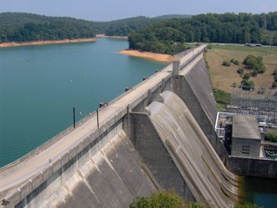
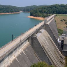
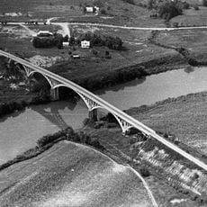
Norris Dam spans the Clinch River, generating electricity while multiple spillways and gates regulate water levels upstream. The structure measures 1,860 feet (567 m) wide and creates a large holding basin behind it.

The Tennessee Valley Authority began construction in 1933 as part of a larger plan to control floods and bring electricity to the region. Work concluded in 1936, marking the first major project by this federal agency.

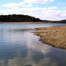
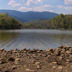
The name honors Senator George Norris, who promoted public power generation and helped establish river control systems across the region. Today the facility serves visitors who come to enjoy the reservoir stretching across multiple counties.

Observation areas and informational panels explain how the facility operates and its role in the surrounding landscape. The reservoir offers opportunities for hiking, fishing, and boating in the nearby areas.

During construction, nearly 3,000 families relocated and over 5,000 graves moved to new sites. Entire villages disappeared beneath the water as the reservoir filled.

The community of curious travelers

AroundUs brings together thousands of curated places, local tips, and hidden gems, enriched daily by 60,000 contributors worldwide.

Start exploring
Location
Location
Inception
1933
Length
567 m
Part of
Historic Resources of the Tennessee Valley Authority Hydroelectric Project, 1933-1979
GPS coordinates
36.22417,-84.09139
Latest update
December 5, 2025 22:29
Around this place
Norris Lake
United States of America

Norris Lake

20.7 km
Museum of Appalachia
United States of America

Museum of Appalachia

5.1 km
American Museum of Science and Energy
United States of America

American Museum of Science and Energy

27.6 km
Norris Dam State Park
United States of America

Norris Dam State Park

2.4 km
Big Ridge State Park
United States of America

Big Ridge State Park

15.7 km
Cove Lake State Park
United States of America

Cove Lake State Park

14.3 km
United States of America

Sharp's Ridge

28 km
Green McAdoo School
United States of America

Green McAdoo School

14.2 km
United Church, The Chapel on the Hill
United States of America

United Church, The Chapel on the Hill

25.5 km
United States of America

University of Tennessee Arboretum

28.2 km
Alexander Inn
United States of America

Alexander Inn

25.6 km
LaFollette House
United States of America

LaFollette House

17.9 km
Children's Museum of Oak Ridge
United States of America

Children's Museum of Oak Ridge

27.6 km
Alexander Bishop House
United States of America

Alexander Bishop House

19.9 km
United States of America

Fort Adair

26.5 km
Savage House and Garden
United States of America

Savage House and Garden

25.1 km
Oak Ridge Historic District
United States of America

Oak Ridge Historic District

26.2 km
Kincaid-Howard House
United States of America

Kincaid-Howard House

20.9 km
J. B. Jones House
United States of America

J. B. Jones House

24.9 km
Luther Brannon House
United States of America

Luther Brannon House

22.7 km
A.E. Perkins House
United States of America

A.E. Perkins House

14.4 km
Dr. Herman Postma Memorial Solway Bridge
United States of America

Dr. Herman Postma Memorial Solway Bridge

27.5 km
Ritz Theatre
United States of America

Ritz Theatre

14.3 km
Cross Mountain Miners' Circle
United States of America

Cross Mountain Miners' Circle

10.2 km
Fraterville Miners' Circle Cemetery
United States of America

Fraterville Miners' Circle Cemetery

4.6 km
Union County Courthouse
United States of America

Union County Courthouse

26.4 km
Norris Dam State Park Rustic Cabins Historic District
United States of America

Norris Dam State Park Rustic Cabins Historic District

499 m
Norris District
United States of America

Norris District

3.6 km
Show the full map
« Norris Dam - Hydroelectric dam in Anderson County, Tennessee, United States » is provided by Around Us (aroundus.com). Images and texts are derived from Wikimedia project under a Creative Commons license. You are allowed to copy, distribute, and modify copies of this page, under the conditions set by the license, as long as this note is clearly visible.

Discover hidden gems everywhere you go!

From secret cafés to breathtaking viewpoints, skip the crowded tourist spots and find places that match your style. Our app makes it easy with voice search, smart filtering, route optimization, and insider tips from travelers worldwide. Download now for the complete mobile experience.

Around Us App Screenshot

A unique approach to discovering new places

Le Figaro

All the places worth exploring

France Info

A tailor-made excursion in just a few clicks

20 Minutes

Around Us
Travel Guide & Maps
Download

Send to your phone

QR Code
1

Open the camera app on your mobile.

2

Point at the QR code with your camera. A notification will appear.

3

Tap the notification to open the link.