Old St. Gabriel's Episcopal Church

Log in to your account

AroundUs is a community-driven map of interesting places, built by curious explorers like you. It grows with every review, story, and photo you share.
Connect to save your favorite spots, contribute locations, and create personalized routes.
Continue with Google
Continue with Apple
Continue with X
Continue with Facebook
Continue with email
By continuing, you accept our Terms and Conditions and our Privacy Policy
Create an account
Add to collection
Map
Suggest a change
Share

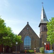
Old St. Gabriel's Episcopal Church, Episcopal church in Douglassville, Pennsylvania, US.

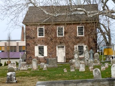
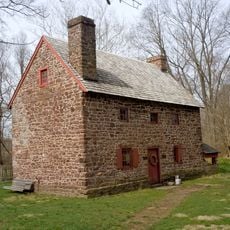
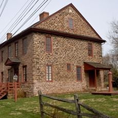
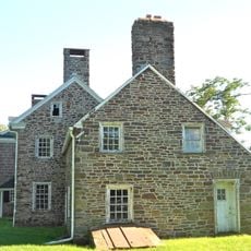
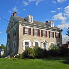
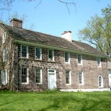
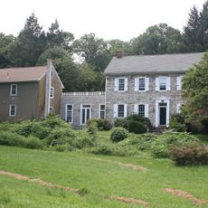
Old St. Gabriel's Episcopal Church is a brownstone building with a distinctive herringbone pattern in its stonework, located in Douglassville, Pennsylvania. The complex houses a restored chapel dating to 1801 next to a larger church structure from 1884, along with administrative offices, classrooms, and a parish hall added through later expansions.

The building was founded in 1720 as a Swedish Lutheran church and shifted to the Church of England in 1760, marking a significant turning point in its religious identity. The congregation played a role in establishing the Episcopal Diocese of Pennsylvania, a milestone that shaped early church history in the region.

The church serves as a longtime spiritual center for its congregation, whose members have marked life milestones like weddings and baptisms within these walls across generations. The cemetery reflects how this place has anchored people's faith and identity in the community for centuries.

The site is easy to locate in Douglassville within Berks County, with modest parking available near the building since it sits in a residential neighborhood. Visitors should know this is an active church complex, so access and visiting hours may vary depending on services or community events happening on site.

Standing as the oldest church in Berks County, this building preserves a rare record of over 300 years of continuous religious life on the same site. This enduring presence makes it a noteworthy document of how communities and their faith practices have evolved across centuries.

Location: Amity Township

GPS coordinates: 40.25722,-75.72917

Latest update: December 14, 2025 17:00

Photos
Around this place
French Creek State Park
United States of America

French Creek State Park

7.4 km
Daniel Boone Homestead
United States of America

Daniel Boone Homestead

7.4 km
Mordecai Lincoln House
United States of America

Mordecai Lincoln House

9.3 km
Pottsgrove Mansion
United States of America

Pottsgrove Mansion

6 km
Hopewell Big Woods
United States of America

Hopewell Big Woods

7.4 km
Pottstown Roller Mill
United States of America

Pottstown Roller Mill

6.7 km
Old Swede's House
United States of America

Old Swede's House

439 m
St. Michael's Episcopal Church
United States of America

St. Michael's Episcopal Church

6.7 km
White Horse Tavern
United States of America

White Horse Tavern

432 m
Old Pottstown Historic District
United States of America

Old Pottstown Historic District

7.1 km
Pine Forge Mansion and Industrial Site
United States of America

Pine Forge Mansion and Industrial Site

3.6 km
Grubb Mansion
United States of America

Grubb Mansion

9.3 km
High Street Historic District
United States of America

High Street Historic District

8.6 km
Henry Fisher House
United States of America

Henry Fisher House

9.7 km
Mill Tract Farm
United States of America

Mill Tract Farm

9.2 km
Weidner Mill
United States of America

Weidner Mill

5.3 km
George Douglass House
United States of America

George Douglass House

276 m
Griesemer-Brown Mill Complex
United States of America

Griesemer-Brown Mill Complex

6.8 km
Sunnybrook
United States of America

Sunnybrook

10.1 km
North Warwick Historic and Archeological District
United States of America

North Warwick Historic and Archeological District

8.4 km
Pottstown Landing Historic District
United States of America

Pottstown Landing Historic District

5.9 km
Coventry Hall
United States of America

Coventry Hall

9.8 km
Rhoads-Lorah House and Barn
United States of America

Rhoads-Lorah House and Barn

7 km
Philip Rogers House
United States of America

Philip Rogers House

9.2 km
Ironstone Bridge
United States of America

Ironstone Bridge

9.6 km
Christ Episcopal Church, Pottstown
United States of America

Christ Episcopal Church, Pottstown

7.1 km
John Knauer House and Mill
United States of America

John Knauer House and Mill

9.6 km
French Creek State Park Six Penny Day Use District
United States of America

French Creek State Park Six Penny Day Use District

6.2 km
Show the full map
Reviews

Visited this place? Tap the stars to rate it and share your experience / photos with the community! Try now! You can cancel it anytime.

« Old St. Gabriel's Episcopal Church - Episcopal church in Douglassville, Pennsylvania, US » is provided by Around Us (aroundus.com). Images and texts are derived from Wikimedia project under a Creative Commons license. You are allowed to copy, distribute, and modify copies of this page, under the conditions set by the license, as long as this note is clearly visible.

Discover hidden gems everywhere you go!

From secret cafés to breathtaking viewpoints, skip the crowded tourist spots and find places that match your style. Our app makes it easy with voice search, smart filtering, route optimization, and insider tips from travelers worldwide. Download now for the complete mobile experience.

Around Us App Screenshot

A unique approach to discovering new places

Le Figaro

All the places worth exploring

France Info

A tailor-made excursion in just a few clicks

20 Minutes