Enable Location

We need your location to show you interesting places around you

Discover nearby places

Find interesting locations and hidden gems around you

Precise directions

Get accurate directions and distances to places

Your location is never shared with other users. It's only used when you tap the location button.

Piscataqua River Bridge

Log in to your account

Start exploring — it's free

Trusted by 62,983 travelers worldwide

Continue with Google
Continue with Apple
or

We will send you a code to connect

By continuing, you accept our Terms and Conditions and our Privacy Policy

Check your inbox

We've sent a pincode in your inbox. Please enter the code below.

Piscataqua River Bridge
Discussion Reviews 1 Photos
10.8k Popularity

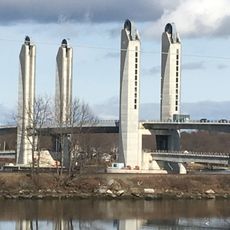
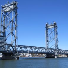
Piscataqua River Bridge, Road bridge between Portsmouth and Kittery, United States.

The Piscataqua River Bridge is a road bridge with a steel arch design that crosses the river between Portsmouth and Kittery. The structure has six lanes and provides clearance above the water for large ships to pass underneath.

The bridge was built between 1968 and 1972 and was the first permanent bridge connection between New Hampshire and Maine on Interstate 95. It replaced ferries and older crossings that had limited traffic flow between the two states.

The bridge represents the economic connection between two states and shapes the identity of the border region. For commuters and travelers, it serves as an everyday crossing that directly links the two communities.

The bridge is busiest during peak hours and can experience traffic congestion. It is best to cross outside rush times if you want to avoid delays.

The bridge carries tens of thousands of vehicles daily and is one of the busiest border crossings in New England. This role makes it a critical infrastructure point for the region.

The community of curious travelers

AroundUs brings together thousands of curated places, local tips, and hidden gems, enriched daily by 60,000 contributors worldwide.

Start exploring
Location
Location
Official opening
1972
GPS coordinates
43.09280,-70.76620
Latest update
December 8, 2025 13:44
Around this place
USS Albacore
United States of America

USS Albacore

1.2 km
Sarah Mildred Long Bridge
United States of America

Sarah Mildred Long Bridge

805 m
Memorial Bridge
United States of America

Memorial Bridge

1.9 km
Richard Jackson House
United States of America

Richard Jackson House

1.3 km
Moffatt-Ladd House
United States of America

Moffatt-Ladd House

1.6 km
Portsmouth Athenæum
United States of America

Portsmouth Athenæum

1.9 km
MacPheadris-Warner House
United States of America

MacPheadris-Warner House

1.9 km
Old North Cemetery
United States of America

Old North Cemetery

1.7 km
Atlantic Heights Development
United States of America

Atlantic Heights Development

498 m
John Paul Jones Memorial Park
United States of America

John Paul Jones Memorial Park

1.5 km
New Hampshire Bank Building
United States of America

New Hampshire Bank Building

1.9 km
Freewill Baptist Church-Peoples Baptist Church-New Hope Church
United States of America

Freewill Baptist Church-Peoples Baptist Church-New Hope Church

1.9 km
Henry Sherburne House
United States of America

Henry Sherburne House

1.6 km
Simeon P. Smith House
United States of America

Simeon P. Smith House

1.6 km
Phoebe Hart House
United States of America

Phoebe Hart House

1.6 km
Dennett Garrison
United States of America

Dennett Garrison

1 km
Joshua Wentworth House
United States of America

Joshua Wentworth House

1.8 km
Daniel Pinkham House
United States of America

Daniel Pinkham House

1.6 km
Nutter-Rymes House
United States of America

Nutter-Rymes House

1.6 km
George Rogers House
United States of America

George Rogers House

1.3 km
Samuel Badger Monument
United States of America

Samuel Badger Monument

1.9 km
Jeremiah Hart House
United States of America

Jeremiah Hart House

1.6 km
Samuel Beck House
United States of America

Samuel Beck House

1.7 km
Hart-Rice House
United States of America

Hart-Rice House

1.6 km
James Neal House
United States of America

James Neal House

1.6 km
John Hart House
United States of America

John Hart House

1.6 km
Whidden-Ward House
United States of America

Whidden-Ward House

1.6 km
Portsmouth Parade Historic District
United States of America

Portsmouth Parade Historic District

1.7 km
Show the full map
Reviews
Share your experience

No review yet

Discussions
Start a discussion...

No discussion yet

« Piscataqua River Bridge - Road bridge between Portsmouth and Kittery, United States » is provided by Around Us (aroundus.com). Images and texts are derived from Wikimedia project under a Creative Commons license. You are allowed to copy, distribute, and modify copies of this page, under the conditions set by the license, as long as this note is clearly visible.

Discover hidden gems everywhere you go!

From secret cafés to breathtaking viewpoints, skip the crowded tourist spots and find places that match your style. Our app makes it easy with voice search, smart filtering, route optimization, and insider tips from travelers worldwide. Download now for the complete mobile experience.

Around Us App Screenshot

A unique approach to discovering new places

Le Figaro

All the places worth exploring

France Info

A tailor-made excursion in just a few clicks

20 Minutes

Around Us
Travel Guide & Maps
Download

Send to your phone

QR Code
1

Open the camera app on your mobile.

2

Point at the QR code with your camera. A notification will appear.

3

Tap the notification to open the link.