Enable Location

We need your location to show you interesting places around you

Discover nearby places

Find interesting locations and hidden gems around you

Precise directions

Get accurate directions and distances to places

Your location is never shared with other users. It's only used when you tap the location button.

Pleasantville Bridge

Log in to your account

Start exploring — it's free

Trusted by 61,553 travelers worldwide

Continue with Google
Continue with Apple
or

We will send you a code to connect

By continuing, you accept our Terms and Conditions and our Privacy Policy

Check your inbox

We've sent a pincode in your inbox. Please enter the code below.

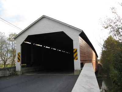
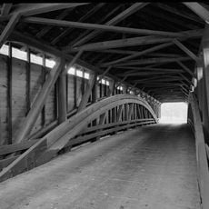
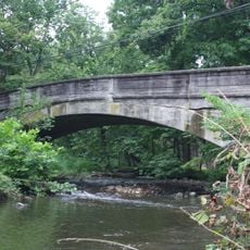
Pleasantville Bridge, Covered bridge in Oley Township, Pennsylvania, US.

Description

Pleasantville Bridge is a wooden covered bridge spanning Manatawny Creek with a length of about 126 feet, using a Burr Truss design that combines curved arches with straight beams. The roof and wooden side walls protect the internal structure from weather exposure.

History

Construction occurred between 1852 and 1856 under the direction of David Renno and Jonathan Bitner. Wood shortages following an early 1850s flood forced the project to proceed in two separate phases.

Culture

The bridge shows how craftspeople once protected wooden structures from the elements while allowing wagons and early vehicles to cross safely. This building approach was standard practice for crossings in the area for many decades.

Practical

The bridge is most easily accessible in stable weather conditions and the roadway is relatively narrow, so vehicles need to travel slowly. Pedestrians and cyclists can also use the structure but should expect to encounter vehicle traffic.

Did you know?

Only five covered bridges remain in Berks County today, making this one of the last examples of a construction method once common throughout the region. Its recognition by the National Register of Historic Places in 1981 helped secure the structure's preservation for future visitors.

Location
GPS coordinates
40.37890,-75.73920
Latest update
December 14, 2025 18:42

AroundUs brings together thousands of curated places, local tips, and hidden gems, enriched daily by 60,000 contributors worldwide. Discover all places nearby (Pennsylvania).

Around this place
Daniel Boone Homestead
United States of America

Daniel Boone Homestead

10.3 km
United States of America

Sacred Oak

6.1 km
Keim Homestead
United States of America

Keim Homestead

3.5 km
Bahr Mill Complex
United States of America

Bahr Mill Complex

8.2 km
Pine Forge Mansion and Industrial Site
United States of America

Pine Forge Mansion and Industrial Site

11 km
Christian Schlegel Farm
United States of America

Christian Schlegel Farm

11.3 km
Dale Furnace and Forge Historic District
United States of America

Dale Furnace and Forge Historic District

11.4 km
Sally Ann Furnace Complex
United States of America

Sally Ann Furnace Complex

10.4 km
Henry Fisher House
United States of America

Henry Fisher House

4.6 km
Knabb-Bieber Mill
United States of America

Knabb-Bieber Mill

6.4 km
Greisemer's Mill Bridge
United States of America

Greisemer's Mill Bridge

1.8 km
Mill Tract Farm
United States of America

Mill Tract Farm

7.4 km
Weidner Mill
United States of America

Weidner Mill

8.3 km
Griesemer-Brown Mill Complex
United States of America

Griesemer-Brown Mill Complex

9.3 km
First National Bank in Fleetwood
United States of America

First National Bank in Fleetwood

10.9 km
Nicholas Johnson Mill
United States of America

Nicholas Johnson Mill

10.6 km
Reiff Farm
United States of America

Reiff Farm

5.9 km
Barto Bridge
United States of America

Barto Bridge

11.2 km
Yoder Mill
United States of America

Yoder Mill

2.5 km
Snyder Mill
United States of America

Snyder Mill

7.3 km
Rhoads-Lorah House and Barn
United States of America

Rhoads-Lorah House and Barn

6.9 km
Hunter's Mill Complex
United States of America

Hunter's Mill Complex

11.4 km
Ironstone Bridge
United States of America

Ironstone Bridge

9.9 km
Mill at Lobachsville
United States of America

Mill at Lobachsville

3.7 km
Hartman Cider Press
United States of America

Hartman Cider Press

3.7 km
Boyertown Museum of Historic Vehicles
United States of America

Boyertown Museum of Historic Vehicles

9.8 km
Levan Farm
United States of America

Levan Farm

12.1 km
Ruth Zimmerman Natural Area
United States of America

Ruth Zimmerman Natural Area

9.3 km
Show the full map
« Pleasantville Bridge - Covered bridge in Oley Township, Pennsylvania, US » is provided by Around Us (aroundus.com). Images and texts are derived from Wikimedia project under a Creative Commons license. You are allowed to copy, distribute, and modify copies of this page, under the conditions set by the license, as long as this note is clearly visible.

Discover hidden gems everywhere you go!

From secret cafés to breathtaking viewpoints, skip the crowded tourist spots and find places that match your style. Our app makes it easy with voice search, smart filtering, route optimization, and insider tips from travelers worldwide. Download now for the complete mobile experience.

Around Us App Screenshot

A unique approach to discovering new places

Le Figaro

All the places worth exploring

France Info

A tailor-made excursion in just a few clicks

20 Minutes

Around Us
Travel Guide & Maps
Download

Send to your phone

QR Code
1

Open the camera app on your mobile.

2

Point at the QR code with your camera. A notification will appear.

3

Tap the notification to open the link.