Enable Location

We need your location to show you interesting places around you

Discover nearby places

Find interesting locations and hidden gems around you

Precise directions

Get accurate directions and distances to places

Your location is never shared with other users. It's only used when you tap the location button.

Rendezvous Mountain Educational State Forest

Log in to your account

Start exploring — it's free

Trusted by 63,026 travelers worldwide

Continue with Google
Continue with Apple
or

We will send you a code to connect

By continuing, you accept our Terms and Conditions and our Privacy Policy

Check your inbox

We've sent a pincode in your inbox. Please enter the code below.

Rendezvous Mountain Educational State Forest
Discussion Reviews 1 Photos
2.9k Popularity

Rendezvous Mountain Educational State Forest, Educational forest in Wilkes County, North Carolina, United States

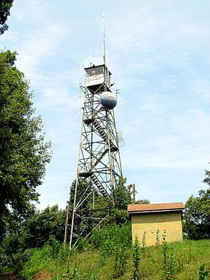
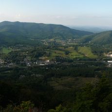
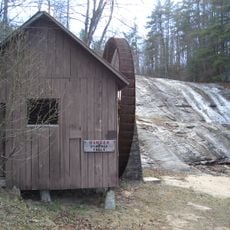
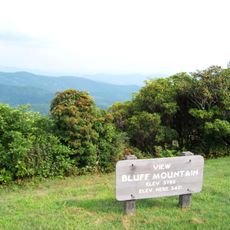
Rendezvous Mountain Educational State Forest is a protected woodland spanning roughly 1800 acres with networks of trails winding through mountain terrain. A restored fire tower at the summit provides panoramic views across the Appalachian region.

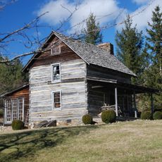
The site became a focus of Civilian Conservation Corps work in the 1930s, when crews built roads, trails, and a summit shelter on the mountain. This effort was part of a nationwide program that shaped forest landscapes across the country during the Depression era.

The name reflects its purpose as a teaching resource for students and visitors learning about forest ecology and land management practices in the region.

Plan your visit during spring through autumn when trails are most accessible and views are clearest. Wear sturdy footwear and bring water, as most routes follow natural or partially maintained terrain.

The mountain served as a Revolutionary War gathering site for Colonel Benjamin Cleveland's militia, making it a location with military historical roots that visitors often overlook. This local significance connects the forest to broader regional conflict during the 1770s.

The community of curious travelers

AroundUs brings together thousands of curated places, local tips, and hidden gems, enriched daily by 60,000 contributors worldwide.

Start exploring
Location
Location
GPS coordinates
36.22707,-81.29370
Latest update
December 12, 2025 12:07
Around this place
North Wilkesboro Speedway
United States of America

North Wilkesboro Speedway

22 km
Stone Mountain State Park
United States of America

Stone Mountain State Park

28.2 km
Cascade Falls
United States of America

Cascade Falls

14.6 km
New River State Park
United States of America

New River State Park

22.6 km
United States of America

Doughton Park

22.4 km
Mount Jefferson State Natural Area
United States of America

Mount Jefferson State Natural Area

24.6 km
Moravian Falls
United States of America

Moravian Falls

18.2 km
Betsey's Rock Falls
United States of America

Betsey's Rock Falls

14.6 km
Brinegar Cabin
United States of America

Brinegar Cabin

25.1 km
Wilkes County Courthouse
United States of America

Wilkes County Courthouse

15.4 km
Robert Cleveland Log House
United States of America

Robert Cleveland Log House

15.2 km
Downtown Main Street Historic District
United States of America

Downtown Main Street Historic District

15.2 km
Ashe County Courthouse
United States of America

Ashe County Courthouse

26.8 km
Brown-Cowles House and Cowles Law Office
United States of America

Brown-Cowles House and Cowles Law Office

15.5 km
Thomas B. Finley House
United States of America

Thomas B. Finley House

14.8 km
Wilkesboro Presbyterian Church
United States of America

Wilkesboro Presbyterian Church

15.6 km
Samuel Cox House
United States of America

Samuel Cox House

27.6 km
Johnson-Hubbard House
United States of America

Johnson-Hubbard House

15.5 km
Riverside
United States of America

Riverside

22.7 km
Downtown Wilkesboro Historic District
United States of America

Downtown Wilkesboro Historic District

15.6 km
Mariah's Chapel
United States of America

Mariah's Chapel

22.3 km
Bower-Cox House
United States of America

Bower-Cox House

25.1 km
A.S. Cooper Farm
United States of America

A.S. Cooper Farm

23.5 km
Thomas B. Finley Law Office
United States of America

Thomas B. Finley Law Office

15.5 km
Federal Building
United States of America

Federal Building

10.4 km
Elbert Crouse Farmstead
United States of America

Elbert Crouse Farmstead

25.1 km
Bluff Mountain Overlook
United States of America

Bluff Mountain Overlook

22 km
Doughton Park Visitor Center
United States of America

Doughton Park Visitor Center

25.3 km
Show the full map
Reviews
Share your experience

No review yet

Discussions
Start a discussion...

No discussion yet

« Rendezvous Mountain Educational State Forest - Educational forest in Wilkes County, North Carolina, United States » is provided by Around Us (aroundus.com). Images and texts are derived from Wikimedia project under a Creative Commons license. You are allowed to copy, distribute, and modify copies of this page, under the conditions set by the license, as long as this note is clearly visible.

Discover hidden gems everywhere you go!

From secret cafés to breathtaking viewpoints, skip the crowded tourist spots and find places that match your style. Our app makes it easy with voice search, smart filtering, route optimization, and insider tips from travelers worldwide. Download now for the complete mobile experience.

Around Us App Screenshot

A unique approach to discovering new places

Le Figaro

All the places worth exploring

France Info

A tailor-made excursion in just a few clicks

20 Minutes

Around Us
Travel Guide & Maps
Download

Send to your phone

QR Code
1

Open the camera app on your mobile.

2

Point at the QR code with your camera. A notification will appear.

3

Tap the notification to open the link.