Enable Location

We need your location to show you interesting places around you

Discover nearby places

Find interesting locations and hidden gems around you

Precise directions

Get accurate directions and distances to places

Your location is never shared with other users. It's only used when you tap the location button.

Log in to your account

Start exploring — it's free

Trusted by 61,676 travelers worldwide

Continue with Google
Continue with Apple
or

We will send you a code to connect

By continuing, you accept our Terms and Conditions and our Privacy Policy

Check your inbox

We've sent a pincode in your inbox. Please enter the code below.

Shark River Inlet

Shark River Inlet, Natural waterway in Monmouth County, New Jersey.

Description

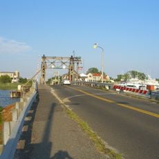
Shark River Inlet is a natural waterway that connects the Atlantic Ocean to the Shark River, flowing between the coastal towns of Belmar and Avon-by-the-Sea. The Ocean Avenue Bascule Bridge spans the inlet and opens multiple times daily to allow boats to pass, with a closed vertical clearance of 9 feet (2.7 meters).

History

The area was called Nolletquesset by the Lenni Lenape people before European maps in the 1800s renamed it White Creek. These name changes reflect how different peoples understood and mapped this coastal region over time.

Culture

The waterway has served as a central place for fishing and boating communities over many generations. The marinas and boat traffic you see today show how deeply maritime life remains woven into the daily rhythm of the surrounding towns.

Practical

The inlet is easily accessible from the coastal roads of Belmar and Avon-by-the-Sea, where you will find several viewpoints and public access areas. Early morning is the best time to watch the bridge openings, as boat traffic is typically heaviest then.

Did you know?

This is the only direct water connection to the Atlantic Ocean in Monmouth County, whereas all nearby rivers flow into Sandy Hook Bay instead. This geographic detail makes the inlet uniquely important for sailboats and larger vessels seeking ocean access.

Location
GPS coordinates
40.18690,-74.00810
Latest update
December 11, 2025 18:02

AroundUs brings together thousands of curated places, local tips, and hidden gems, enriched daily by 60,000 contributors worldwide. Discover all places nearby (New Jersey).

Around this place
The Stone Pony
United States of America

The Stone Pony

3.7 km
Shadow Lawn
United States of America

Shadow Lawn

10.3 km
Tillie
United States of America

Tillie

3.5 km
Palace Amusements
United States of America

Palace Amusements

3.5 km
Paramount Theatre
United States of America

Paramount Theatre

4.2 km
Allaire Village
United States of America

Allaire Village

10.6 km
Camp Evans
United States of America

Camp Evans

4.2 km
United States of America

Garfield Tea House

8.6 km
Asbury Lanes
United States of America

Asbury Lanes

4.1 km
Church of the Presidents
United States of America

Church of the Presidents

8.6 km
Glimmer Glass Bridge
United States of America

Glimmer Glass Bridge

8.9 km
Synagogue of Deal
United States of America

Synagogue of Deal

7.3 km
Murry Guggenheim House
United States of America

Murry Guggenheim House

10.6 km
Shark River Park
United States of America

Shark River Park

7.3 km
Sea Girt Light
United States of America

Sea Girt Light

5.8 km
United States of America

National Guard Militia Museum of New Jersey

7.7 km
Martin Maloney Cottage
United States of America

Martin Maloney Cottage

4.2 km
United States of America

St. Catharine Church, Spring Lake

4.7 km
Audenried Cottage
United States of America

Audenried Cottage

3.4 km
Manasquan Friends Meetinghouse and Burying Ground
United States of America

Manasquan Friends Meetinghouse and Burying Ground

7.7 km
Lauren K. Woods Theatre
United States of America

Lauren K. Woods Theatre

10.5 km
Belmar Public Library
United States of America

Belmar Public Library

1.6 km
Winsor Building
United States of America

Winsor Building

3.4 km
Asbury Park Pedal Boats
United States of America

Asbury Park Pedal Boats

3.3 km
Bradley Beach Public Library
United States of America

Bradley Beach Public Library

1.6 km
Belmar Marconi Station
United States of America

Belmar Marconi Station

4.3 km
Allenhurst Residential Historic District
United States of America

Allenhurst Residential Historic District

5.5 km
Asbury Park Commercial Historic District
United States of America

Asbury Park Commercial Historic District

3.3 km
Show the full map
« Shark River Inlet - Natural waterway in Monmouth County, New Jersey » is provided by Around Us (aroundus.com). Images and texts are derived from Wikimedia project under a Creative Commons license. You are allowed to copy, distribute, and modify copies of this page, under the conditions set by the license, as long as this note is clearly visible.

Discover hidden gems everywhere you go!

From secret cafés to breathtaking viewpoints, skip the crowded tourist spots and find places that match your style. Our app makes it easy with voice search, smart filtering, route optimization, and insider tips from travelers worldwide. Download now for the complete mobile experience.

Around Us App Screenshot

A unique approach to discovering new places

Le Figaro

All the places worth exploring

France Info

A tailor-made excursion in just a few clicks

20 Minutes

Around Us
Travel Guide & Maps
Download

Send to your phone

QR Code
1

Open the camera app on your mobile.

2

Point at the QR code with your camera. A notification will appear.

3

Tap the notification to open the link.