Enable Location

We need your location to show you interesting places around you

Discover nearby places

Find interesting locations and hidden gems around you

Precise directions

Get accurate directions and distances to places

Your location is never shared with other users. It's only used when you tap the location button.

Silver Mound Archeological District

Log in to your account

Start exploring — it's free

Trusted by 62,949 travelers worldwide

Continue with Google
Continue with Apple
or

We will send you a code to connect

By continuing, you accept our Terms and Conditions and our Privacy Policy

Check your inbox

We've sent a pincode in your inbox. Please enter the code below.

Discussion Reviews 1 Photos
2k Popularity

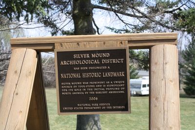
Silver Mound Archeological District, Native American archaeological site in Jackson County, Wisconsin.

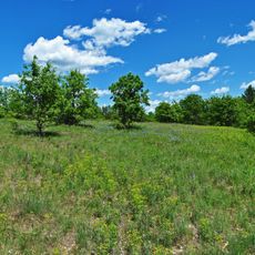
Silver Mound is an archaeological district in Wisconsin where quarry pits reveal that Indigenous peoples mined and worked quartzite for thousands of years. The landscape contains numerous extraction pits, workshop areas, and rock shelters that show the scope of ancient activity at this location.

The site was first used about 11,000 years ago when early peoples inhabited the region. Over many centuries, it became a major quartzite extraction center, revealing its role in ancient trade networks across North America.

Rock shelters nestled along the bluff display paintings and carvings that reflect the spiritual beliefs of Indigenous peoples. These artworks reveal how the land held deep meaning and connection for those who lived here.

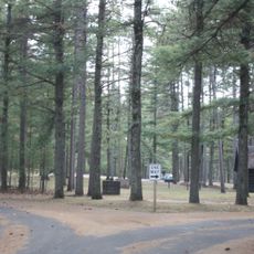
The district features marked trails and interpretive signage showing where mining and stone work took place. Wear sturdy shoes since the terrain is uneven and the area is exposed to outdoor conditions.

Tools made from this quartzite turned up hundreds of miles away across multiple states, showing that prehistoric people maintained long-distance trade routes. This discovery reveals that this mining area held importance for groups living far beyond the region.

The community of curious travelers

AroundUs brings together thousands of curated places, local tips, and hidden gems, enriched daily by 60,000 contributors worldwide.

Start exploring
Location
GPS coordinates
44.42667,-90.95972
Latest update
December 14, 2025 11:05
Around this place
Clark County Jail
United States of America

Clark County Jail

32.7 km
Black River State Forest
United States of America

Black River State Forest

26.3 km
Dells Mill
United States of America

Dells Mill

36.5 km
Wisconsin Pavilion
United States of America

Wisconsin Pavilion

33.3 km
Jellystone Waterpark
United States of America

Jellystone Waterpark

48.3 km
Tollef Jensen House
United States of America

Tollef Jensen House

49.8 km
Omaha Hotel
United States of America

Omaha Hotel

32.3 km
Arcadia Free Public Library
United States of America

Arcadia Free Public Library

46.9 km
Black River Falls Public Library
United States of America

Black River Falls Public Library

17 km
Neillsville Downtown Historic District
United States of America

Neillsville Downtown Historic District

32.5 km
Black Hawk Powwow Grounds
United States of America

Black Hawk Powwow Grounds

20.3 km
John and Maria Hein House
United States of America

John and Maria Hein House

32.7 km
First Church of Christ, Scientist
United States of America

First Church of Christ, Scientist

32.4 km
Downtown Historic District
United States of America

Downtown Historic District

49.3 km
Decatur and Kate Dickinson House
United States of America

Decatur and Kate Dickinson House

32.7 km
Ridge Avenue Historic District
United States of America

Ridge Avenue Historic District

49.5 km
Charles Foote House
United States of America

Charles Foote House

34.3 km
John F. Cance House
United States of America

John F. Cance House

49.1 km
Canoe Landing Prairie State Natural Area
United States of America

Canoe Landing Prairie State Natural Area

34.2 km
California Wine and Liquor Store
United States of America

California Wine and Liquor Store

19.4 km
Forrest D. and Marian Calway House
United States of America

Forrest D. and Marian Calway House

32.7 km
Herman M. and Hanna Hediger House
United States of America

Herman M. and Hanna Hediger House

31.9 km
Neillsville Masonic Temple Lodge No. 163
United States of America

Neillsville Masonic Temple Lodge No. 163

32.5 km
Robert Schofield House
United States of America

Robert Schofield House

47 km
George W. and Sarah Trogner House
United States of America

George W. and Sarah Trogner House

32.1 km
William B. and Jennie Tufts House
United States of America

William B. and Jennie Tufts House

32.7 km
Cranberry Discovery Center
United States of America

Cranberry Discovery Center

49.3 km
Strike Time Lanes
United States of America

Strike Time Lanes

32 km
Show the full map
Reviews
Share your experience

No review yet

Discussions
Start a discussion...

No discussion yet

« Silver Mound Archeological District - Native American archaeological site in Jackson County, Wisconsin » is provided by Around Us (aroundus.com). Images and texts are derived from Wikimedia project under a Creative Commons license. You are allowed to copy, distribute, and modify copies of this page, under the conditions set by the license, as long as this note is clearly visible.

Discover hidden gems everywhere you go!

From secret cafés to breathtaking viewpoints, skip the crowded tourist spots and find places that match your style. Our app makes it easy with voice search, smart filtering, route optimization, and insider tips from travelers worldwide. Download now for the complete mobile experience.

Around Us App Screenshot

A unique approach to discovering new places

Le Figaro

All the places worth exploring

France Info

A tailor-made excursion in just a few clicks

20 Minutes

Around Us
Travel Guide & Maps
Download

Send to your phone

QR Code
1

Open the camera app on your mobile.

2

Point at the QR code with your camera. A notification will appear.

3

Tap the notification to open the link.