Enable Location

We need your location to show you interesting places around you

Discover nearby places

Find interesting locations and hidden gems around you

Precise directions

Get accurate directions and distances to places

Your location is never shared with other users. It's only used when you tap the location button.

West Park Bridge

Log in to your account

Start exploring — it's free

Trusted by 62,351 travelers worldwide

Continue with Google
Continue with Apple
or

We will send you a code to connect

By continuing, you accept our Terms and Conditions and our Privacy Policy

Check your inbox

We've sent a pincode in your inbox. Please enter the code below.

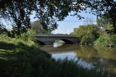
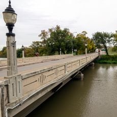
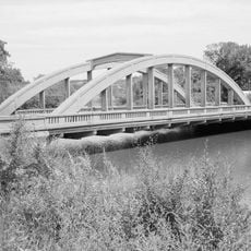
West Park Bridge, bridge in United States of America

West Park Bridge is a concrete road bridge with a false arch design that spans the Sheyenne River and connects two parts of the city. The structure sits in a quiet area with trees and green space, and features classic lamps along its sides that give it a distinctive character.

The bridge was built in 1924 and showcases early 1900s construction methods with its unusual false arch design. It was added to the National Register of Historic Places in 1997, securing protection for future generations.

The bridge takes its name from the park area it connects to the rest of the city. Today it remains a familiar landmark for locals and visitors who use the quiet riverside setting for walks and moments of reflection.

Access to the bridge is straightforward via 4th Street Southwest, where both drivers and pedestrians can use the structure. The location is very quiet and surrounded by trees, making it ideal for brief stops during a drive or walk.

The bridge uses an unusual false arch design that was uncommon for small towns at the time, showing how much aesthetics mattered in early bridge design. This design choice made it more than just a practical crossing and gave it a visual elegance that visitors still notice today.

The community of curious travelers

AroundUs brings together thousands of curated places, local tips, and hidden gems, enriched daily by 60,000 contributors worldwide.

Start exploring
Location
GPS coordinates
46.92056,-98.00833
Latest update
February 9, 2026 07:40
Around this place
World's Largest Buffalo
United States of America

World's Largest Buffalo

52.6 km
Hi-Line Railroad Bridge
United States of America

Hi-Line Railroad Bridge

2.3 km
Fort Ransom State Park
United States of America

Fort Ransom State Park

42.2 km
Basilica of St. James
United States of America

Basilica of St. James

53.3 km
Stutsman County Courthouse and Sheriff's Residence/Jail
United States of America

Stutsman County Courthouse and Sheriff's Residence/Jail

53.1 km
United States of America

North Dakota Winter Show

1.2 km
St. Stephen's Episcopal Church
United States of America

St. Stephen's Episcopal Church

60.8 km
State Normal School at Valley City Historic District
United States of America

State Normal School at Valley City Historic District

508 m
Lisbon Bridge
United States of America

Lisbon Bridge

58.3 km
Rainbow Arch Bridge
United States of America

Rainbow Arch Bridge

510 m
Lisbon Opera House
United States of America

Lisbon Opera House

58.8 km
Alfred E. Dickey Free Library
United States of America

Alfred E. Dickey Free Library

53.2 km
Old Stone Church
United States of America

Old Stone Church

34.8 km
Valley City Municipal Auditorium
United States of America

Valley City Municipal Auditorium

402 m
Grace Episcopal Church
United States of America

Grace Episcopal Church

53.1 km
Barnes County Courthouse
United States of America

Barnes County Courthouse

784 m
Ransom County Courthouse
United States of America

Ransom County Courthouse

58.7 km
Voorhees Chapel
United States of America

Voorhees Chapel

52.5 km
Griggs County Courthouse
United States of America

Griggs County Courthouse

58.7 km
All Saints Episcopal Church
United States of America

All Saints Episcopal Church

1 km
Northern Lights Masonic Lodge
United States of America

Northern Lights Masonic Lodge

58.8 km
Elizabeth Apartments
United States of America

Elizabeth Apartments

53.3 km
Casselton Commercial Historic District
United States of America

Casselton Commercial Historic District

60.7 km
Valley City Carnegie Library
United States of America

Valley City Carnegie Library

763 m
T. J. Walker Historic District
United States of America

T. J. Walker Historic District

44.8 km
Franklin School
United States of America

Franklin School

53.5 km
Amphitheater and Fieldstone WPA Features at Valley City Pioneer Park
United States of America

Amphitheater and Fieldstone WPA Features at Valley City Pioneer Park

891 m
Sheyenne River Bridge
United States of America

Sheyenne River Bridge

38.4 km
Show the full map
« West Park Bridge - bridge in United States of America » is provided by Around Us (aroundus.com). Images and texts are derived from Wikimedia project under a Creative Commons license. You are allowed to copy, distribute, and modify copies of this page, under the conditions set by the license, as long as this note is clearly visible.

Discover hidden gems everywhere you go!

From secret cafés to breathtaking viewpoints, skip the crowded tourist spots and find places that match your style. Our app makes it easy with voice search, smart filtering, route optimization, and insider tips from travelers worldwide. Download now for the complete mobile experience.

Around Us App Screenshot

A unique approach to discovering new places

Le Figaro

All the places worth exploring

France Info

A tailor-made excursion in just a few clicks

20 Minutes

Around Us
Travel Guide & Maps
Download

Send to your phone

QR Code
1

Open the camera app on your mobile.

2

Point at the QR code with your camera. A notification will appear.

3

Tap the notification to open the link.