Enable Location

We need your location to show you interesting places around you

Discover nearby places

Find interesting locations and hidden gems around you

Precise directions

Get accurate directions and distances to places

Your location is never shared with other users. It's only used when you tap the location button.

Kern Bridge

Log in to your account

Start exploring — it's free

Trusted by 61,905 travelers worldwide

Continue with Google
Continue with Apple
or

We will send you a code to connect

By continuing, you accept our Terms and Conditions and our Privacy Policy

Check your inbox

We've sent a pincode in your inbox. Please enter the code below.

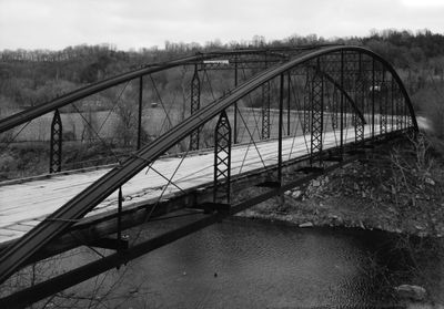
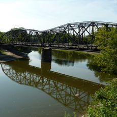
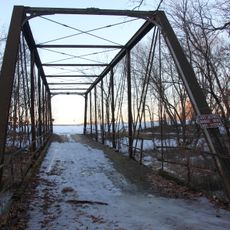
Kern Bridge, Bowstring arch bridge in Blue Earth County, US

Kern Bridge is a bowstring arch bridge spanning 189 feet (58 meters) across the Le Sueur River with a wrought-iron framework. The structure rests on limestone supports at each end and displays the curved metal truss design typical of 1870s industrial engineering.

The bridge was built in 1873 by the Wrought Iron Bridge Company and served as a vital transportation route for over a century. It was closed to vehicles in 1991 and later dismantled in 2020 to be relocated to a new site.

The bridge represents a significant period in American engineering when builders transitioned from wood and stone construction methods to metal-based architectural solutions.

The bridge sits in a riverside setting and is approachable from adjacent parks, reachable by foot or bicycle. Visitors should expect uneven ground and weather-dependent conditions when viewing the structure in its planned location.

This is the longest surviving example of this specific arch type across the entire United States and the only known structure of its kind in Minnesota. The rare construction method makes it a valuable record of iron bridge engineering from the 1800s.

The community of curious travelers

AroundUs brings together thousands of curated places, local tips, and hidden gems, enriched daily by 60,000 contributors worldwide.

Start exploring
Architects
Wrought Iron Bridge Company
GPS coordinates
44.10980,-94.04190
Latest update
December 14, 2025 16:43
Around this place
Minneopa State Park
United States of America

Minneopa State Park

7.6 km
Seppman Mill
United States of America

Seppman Mill

8.3 km
Lorin Cray House
United States of America

Lorin Cray House

6.5 km
First National Bank of Mankato
United States of America

First National Bank of Mankato

7 km
Blue Earth County Courthouse
United States of America

Blue Earth County Courthouse

6.9 km
Wow Zone
United States of America

Wow Zone

10.5 km
Renesselaer D. Hubbard House
United States of America

Renesselaer D. Hubbard House

6.5 km
Nicollet County Courthouse and Jail
United States of America

Nicollet County Courthouse and Jail

24.5 km
Eugene Saint Julien Cox House
United States of America

Eugene Saint Julien Cox House

25.6 km
First Baptist Church
United States of America

First Baptist Church

12.2 km
First Presbyterian Church
United States of America

First Presbyterian Church

6.9 km
Old Main
United States of America

Old Main

6.7 km
St. Peter Armory
United States of America

St. Peter Armory

24.6 km
Broadway Bridge
United States of America

Broadway Bridge

25 km
Union Presbyterian Church
United States of America

Union Presbyterian Church

24.3 km
Sterling Congregational Church
United States of America

Sterling Congregational Church

23.5 km
Lucas Troendle House
United States of America

Lucas Troendle House

21.4 km
Emily and Stephen Schumacher House
United States of America

Emily and Stephen Schumacher House

25.2 km
Shanaska Creek Bridge
United States of America

Shanaska Creek Bridge

20.9 km
Janesville Free Public Library
United States of America

Janesville Free Public Library

26.7 km
Adolph O. Eberhart House
United States of America

Adolph O. Eberhart House

6.1 km
J.R. Brandrup House
United States of America

J.R. Brandrup House

5.6 km
Charles Chapman House
United States of America

Charles Chapman House

5.1 km
Mapleton Public Library
United States of America

Mapleton Public Library

21.3 km
William Irving House
United States of America

William Irving House

5.8 km
Minneopa State Park WPA/Rustic Style Historic Resources
United States of America

Minneopa State Park WPA/Rustic Style Historic Resources

5.9 km
Splash Pad
United States of America

Splash Pad

21.6 km
Linnaeus Arboretum
United States of America

Linnaeus Arboretum

24 km
Show the full map
« Kern Bridge - Bowstring arch bridge in Blue Earth County, US » is provided by Around Us (aroundus.com). Images and texts are derived from Wikimedia project under a Creative Commons license. You are allowed to copy, distribute, and modify copies of this page, under the conditions set by the license, as long as this note is clearly visible.

Discover hidden gems everywhere you go!

From secret cafés to breathtaking viewpoints, skip the crowded tourist spots and find places that match your style. Our app makes it easy with voice search, smart filtering, route optimization, and insider tips from travelers worldwide. Download now for the complete mobile experience.

Around Us App Screenshot

A unique approach to discovering new places

Le Figaro

All the places worth exploring

France Info

A tailor-made excursion in just a few clicks

20 Minutes

Around Us
Travel Guide & Maps
Download

Send to your phone

QR Code
1

Open the camera app on your mobile.

2

Point at the QR code with your camera. A notification will appear.

3

Tap the notification to open the link.