·

Enable Location

We need your location to show you interesting places around you

Discover nearby places

Find interesting locations and hidden gems around you

Precise directions

Get accurate directions and distances to places

Your location is never shared with other users. It's only used when you tap the location button.

Chenoweth Fort-Springhouse

Log in to your account

Start exploring — it's free

Trusted by 62,631 travelers worldwide

Continue with Google
Continue with Apple
or

We will send you a code to connect

By continuing, you accept our Terms and Conditions and our Privacy Policy

Check your inbox

We've sent a pincode in your inbox. Please enter the code below.

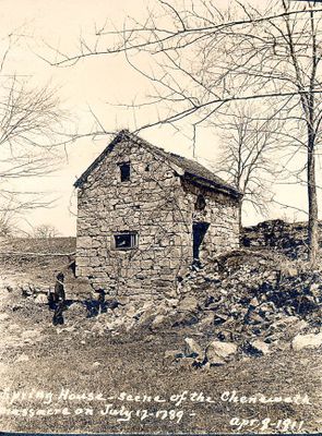
Chenoweth Fort-Springhouse, building in Jefferson County, Kentucky, United States

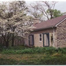
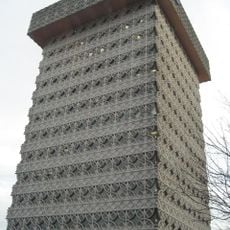
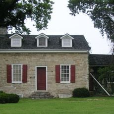
The Chenoweth Fort-Springhouse is a stone building from the late 1700s located in Jefferson County. The structure has two stories built directly over a natural spring and features a simple, sturdy design with ground floor access and a ladder leading to an upper defensive level.

The building was constructed around 1786 by Richard Chenoweth, one of the area's first settlers, and is believed to be the oldest surviving structure in Louisville. In 1789, the springhouse provided crucial shelter when the family took refuge there during an attack by Native American fighters.

The name comes from Richard Chenoweth, one of the first white settlers in the area who shaped this place. The building shows how early families constructed homes from stone and depended on natural springs to survive in new territory.

The springhouse sits on private land in a wooded area near Middletown and is accessible to those interested in history. Wearing comfortable shoes and bringing water are advisable since the surroundings are natural and quiet.

The springhouse is believed to be the oldest surviving building in Louisville and has endured for centuries in the Kentucky woods despite being forgotten for many years. Not until the 1970s did volunteers begin restoring the house to preserve its story for future generations.

The community of curious travelers

AroundUs brings together thousands of curated places, local tips, and hidden gems, enriched daily by 60,000 contributors worldwide.

Start exploring
Location
GPS coordinates
38.26139,-85.50583
Latest update
February 9, 2026 07:41
Around this place
Pope Lick Monster
United States of America

Pope Lick Monster

7.9 km
Zachary Taylor National Cemetery
United States of America

Zachary Taylor National Cemetery

12.1 km
E. P. "Tom" Sawyer State Park
United States of America

E. P. "Tom" Sawyer State Park

5.3 km
Oxmoor Farm
United States of America

Oxmoor Farm

9.4 km
Blackacre Nature Preserve and Historic Homestead
United States of America

Blackacre Nature Preserve and Historic Homestead

7.6 km
Pewee Valley Confederate Cemetery
United States of America

Pewee Valley Confederate Cemetery

5.3 km
Whitney Young Birthplace and Museum
United States of America

Whitney Young Birthplace and Museum

12.5 km
Bellevoir-Ormsby Village
United States of America

Bellevoir-Ormsby Village

6.1 km
Confederate Martyrs Monument in Jeffersontown
United States of America

Confederate Martyrs Monument in Jeffersontown

9.6 km
Von Allmen Dairy Farm House
United States of America

Von Allmen Dairy Farm House

8.3 km
Presbyterian Manse
United States of America

Presbyterian Manse

3.4 km
Harrods Creek Baptist Church and Rev. William Kellar House
United States of America

Harrods Creek Baptist Church and Rev. William Kellar House

10.9 km
Saint James' Episcopal Church
United States of America

Saint James' Episcopal Church

6 km
Wooldridge-Rose House
United States of America

Wooldridge-Rose House

6.4 km
Hausgen House
United States of America

Hausgen House

3.6 km
James Thompson House
United States of America

James Thompson House

3.6 km
Bondurant-Hustin House
United States of America

Bondurant-Hustin House

5 km
Shallcross
United States of America

Shallcross

2.6 km
Ridgeway
United States of America

Ridgeway

12.4 km
Albert E. Clore House
United States of America

Albert E. Clore House

8 km
Nash-McDonald House
United States of America

Nash-McDonald House

3.4 km
Robert May House
United States of America

Robert May House

3.7 km
Long Run Baptist Church and Cemetery
United States of America

Long Run Baptist Church and Cemetery

8.1 km
Calypso Cove
United States of America

Calypso Cove

6.4 km
Kaden Tower
United States of America

Kaden Tower

12.2 km
Masonic Hall
United States of America

Masonic Hall

8.9 km
Confederate Memorial in Peewee Valley
United States of America

Confederate Memorial in Peewee Valley

5.4 km
Eight-Mile House
United States of America

Eight-Mile House

8.6 km
Show the full map
« Chenoweth Fort-Springhouse - building in Jefferson County, Kentucky, United States » is provided by Around Us (aroundus.com). Images and texts are derived from Wikimedia project under a Creative Commons license. You are allowed to copy, distribute, and modify copies of this page, under the conditions set by the license, as long as this note is clearly visible.

Discover hidden gems everywhere you go!

From secret cafés to breathtaking viewpoints, skip the crowded tourist spots and find places that match your style. Our app makes it easy with voice search, smart filtering, route optimization, and insider tips from travelers worldwide. Download now for the complete mobile experience.

Around Us App Screenshot

A unique approach to discovering new places

Le Figaro

All the places worth exploring

France Info

A tailor-made excursion in just a few clicks

20 Minutes

Around Us
Travel Guide & Maps
Download

Send to your phone

QR Code
1

Open the camera app on your mobile.

2

Point at the QR code with your camera. A notification will appear.

3

Tap the notification to open the link.