Enable Location

We need your location to show you interesting places around you

Discover nearby places

Find interesting locations and hidden gems around you

Precise directions

Get accurate directions and distances to places

Your location is never shared with other users. It's only used when you tap the location button.

Fort Ripley

Log in to your account

Start exploring — it's free

Trusted by 62,953 travelers worldwide

Continue with Google
Continue with Apple
or

We will send you a code to connect

By continuing, you accept our Terms and Conditions and our Privacy Policy

Check your inbox

We've sent a pincode in your inbox. Please enter the code below.

Discussion Reviews 1 Photos
4.2k Popularity

Fort Ripley, Military fort in Morrison County, United States.

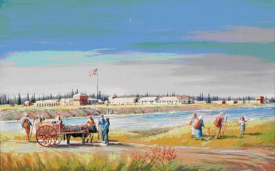
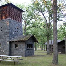
Fort Ripley was a military post with timber structures arranged around a central courtyard, featuring three defensive blockhouses and a partial wooden fortification facing the river. The layout reflected standard Army fort design of the period.

Established in 1848 as an Army outpost to protect settlers and monitor Native American movements, it closed in 1877. The site played a significant role for the Union during the American Civil War period.

The site became a meeting point between military personnel and local inhabitants, shaping how the region developed during the 1800s. People passing through the area noticed how the fort influenced where settlements grew.

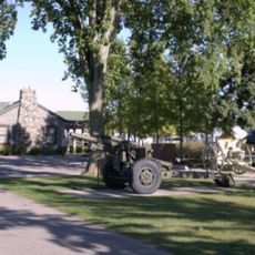
The site is now part of Camp Ripley training facility and remains accessible through Morrison County resources. Check current conditions before visiting since the grounds serve as an active National Guard training area.

During the winter of 1863-1864, the post housed 400 cavalry soldiers and 500 horses, making it a major supply point during the Civil War. This scale of animal husbandry was unusual for the region at that time.

The community of curious travelers

AroundUs brings together thousands of curated places, local tips, and hidden gems, enriched daily by 60,000 contributors worldwide.

Start exploring
Location
Inception
1848
GPS coordinates
46.17556,-94.37306
Latest update
December 18, 2025 11:40
Around this place
Charles A. Lindbergh State Park
United States of America

Charles A. Lindbergh State Park

24.2 km
Crow Wing State Park
United States of America

Crow Wing State Park

11.2 km
Minnesota Military Museum
United States of America

Minnesota Military Museum

10.7 km
Crow Wing County Courthouse and Jail
United States of America

Crow Wing County Courthouse and Jail

23.9 km
United States of America

Northland Arboretum

23.2 km
Church of Our Savior-Episcopal
United States of America

Church of Our Savior-Episcopal

22.2 km
Camp Ripley Bridge
United States of America

Camp Ripley Bridge

11.6 km
Charles A. Weyerhaeuser and Musser Houses
United States of America

Charles A. Weyerhaeuser and Musser Houses

22.8 km
Burton-Rosenmeier House
United States of America

Burton-Rosenmeier House

22.8 km
Parker Building
United States of America

Parker Building

24.1 km
United States of America

Broadway Bridge

22.1 km
Minnesota Highway 371 Bridge
United States of America

Minnesota Highway 371 Bridge

17.3 km
Morrison County Courthouse
United States of America

Morrison County Courthouse

22.3 km
Pine Tree Lumber Company Office Building
United States of America

Pine Tree Lumber Company Office Building

21.3 km
Washington Street Bridge
United States of America

Washington Street Bridge

23.8 km
Little Falls Carnegie Library
United States of America

Little Falls Carnegie Library

22.2 km
Little Falls Commercial Historic District
United States of America

Little Falls Commercial Historic District

22.2 km
United States of America

Bane Park

22.7 km
Charles A. Lindbergh State Park WPA/Rustic Style Historic Resources
United States of America

Charles A. Lindbergh State Park WPA/Rustic Style Historic Resources

24.3 km
Charles Lindbergh House and Museum
United States of America

Charles Lindbergh House and Museum

24 km
Minnesota Fishing Museum
United States of America

Minnesota Fishing Museum

22.1 km
United States of America

Nokasippi River Historical Monument

899 m
United States of America

Lake Placid

18.5 km
United States of America

Legacy Courses at Cragun's

23.8 km
United States of America

Disc golf course

15.8 km
United States of America

Eagle's Landing Golf Club and Grill

4.6 km
United States of America

Paul Bunyan Statue

10.3 km
United States of America

Observation deck

18.8 km
Show the full map
Reviews
Share your experience

No review yet

Discussions
Start a discussion...

No discussion yet

« Fort Ripley - Military fort in Morrison County, United States » is provided by Around Us (aroundus.com). Images and texts are derived from Wikimedia project under a Creative Commons license. You are allowed to copy, distribute, and modify copies of this page, under the conditions set by the license, as long as this note is clearly visible.

Discover hidden gems everywhere you go!

From secret cafés to breathtaking viewpoints, skip the crowded tourist spots and find places that match your style. Our app makes it easy with voice search, smart filtering, route optimization, and insider tips from travelers worldwide. Download now for the complete mobile experience.

Around Us App Screenshot

A unique approach to discovering new places

Le Figaro

All the places worth exploring

France Info

A tailor-made excursion in just a few clicks

20 Minutes

Around Us
Travel Guide & Maps
Download

Send to your phone

QR Code
1

Open the camera app on your mobile.

2

Point at the QR code with your camera. A notification will appear.

3

Tap the notification to open the link.