·

Enable Location

We need your location to show you interesting places around you

Discover nearby places

Find interesting locations and hidden gems around you

Precise directions

Get accurate directions and distances to places

Your location is never shared with other users. It's only used when you tap the location button.

Log in to your account

Start exploring — it's free

Trusted by 62,750 travelers worldwide

Continue with Google
Continue with Apple
or

We will send you a code to connect

By continuing, you accept our Terms and Conditions and our Privacy Policy

Check your inbox

We've sent a pincode in your inbox. Please enter the code below.

Schwerdt Site

Schwerdt Site, Archaeological site near Kalamazoo River, Michigan, United States

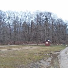
This archaeological site near the Kalamazoo River in Michigan contains the remains of a prehistoric camp with over 40 structural features visible in the ground. Excavations have revealed cooking pits, pottery fragments, and animal bones that show how people prepared food and lived during their time here.

The camp was occupied between roughly 1400 and 1600 and represents the final era of Native American settlement in this region. Archaeologists discovered the site in the 1970s, which allowed them to learn about the last generations of people who lived by hunting and gathering before European contact.

The pottery found here shows connections to Algonkian-speaking peoples, with ceramic pieces reflecting regional styles from different time periods. Visitors can understand through these objects how people lived and traded with neighboring communities.

The site is located in a rural area and is accessible to visitors but offers limited facilities on the ground. It is best to research the exact location beforehand and bring plenty of water and sun protection, especially during warmer months.

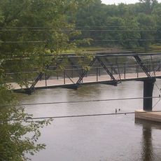
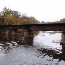
The camp likely served as a seasonal settlement occupied only during spring and early summer months. This timing aligned with the annual migration of sturgeon in the Kalamazoo River, which provided a key food source for the people living here.

The community of curious travelers

AroundUs brings together thousands of curated places, local tips, and hidden gems, enriched daily by 60,000 contributors worldwide.

Start exploring
GPS coordinates
42.66667,-86.00000
Latest update
December 14, 2025 13:08
Around this place
Lake Allegan
United States of America

Lake Allegan

14.1 km
Old Wing Mission
United States of America

Old Wing Mission

12.6 km
United States of America

Allegan State Game Area

11.4 km
New Richmond Swing Bridge
United States of America

New Richmond Swing Bridge

8.9 km
Max and Esther De Pree House
United States of America

Max and Esther De Pree House

15.6 km
Benjamin Van Raalte House
United States of America

Benjamin Van Raalte House

13.7 km
Hacklander Site
United States of America

Hacklander Site

13.7 km
United States of America

Allegan State Forest

15.1 km
Zeeland Cemetery Historical Marker
United States of America

Zeeland Cemetery Historical Marker

15.8 km
CSX Kalamazoo River Bridge
United States of America

CSX Kalamazoo River Bridge

8.9 km
United States of America

Winding Creek Golf Club

10.8 km
United States of America

Natura Extensa

15.8 km
United States of America

Ravines Golf Club

12.1 km
United States of America

The Links At Rolling Meadows

13.8 km
United States of America

Lake Monterey Golf Course

14.9 km
United States of America

Saugatuck Dune Rides

15.2 km
United States of America

Ridge Point Ampitheater

12.3 km
United States of America

Ballyviktor

15.8 km
United States of America

Fanned Arena

15.8 km
United States of America

Clearbrook

14.9 km
United States of America

Ignite

15.7 km
United States of America

Ziipi Elpidos

15.7 km
United States of America

Cross Stone (Khachkar)

15.7 km
United States of America

Pulse of Morning II

15.7 km
United States of America

Midwinter Horn

15.7 km
United States of America

Work of art, sculpture

13.9 km
United States of America

Scenic viewpoint

15.7 km
United States of America

Upper Macatawa Natural Area Scenic Overlook

14.7 km
Show the full map
« Schwerdt Site - Archaeological site near Kalamazoo River, Michigan, United States » is provided by Around Us (aroundus.com). Images and texts are derived from Wikimedia project under a Creative Commons license. You are allowed to copy, distribute, and modify copies of this page, under the conditions set by the license, as long as this note is clearly visible.

Discover hidden gems everywhere you go!

From secret cafés to breathtaking viewpoints, skip the crowded tourist spots and find places that match your style. Our app makes it easy with voice search, smart filtering, route optimization, and insider tips from travelers worldwide. Download now for the complete mobile experience.

Around Us App Screenshot

A unique approach to discovering new places

Le Figaro

All the places worth exploring

France Info

A tailor-made excursion in just a few clicks

20 Minutes

Around Us
Travel Guide & Maps
Download

Send to your phone

QR Code
1

Open the camera app on your mobile.

2

Point at the QR code with your camera. A notification will appear.

3

Tap the notification to open the link.