Enable Location

We need your location to show you interesting places around you

Discover nearby places

Find interesting locations and hidden gems around you

Precise directions

Get accurate directions and distances to places

Your location is never shared with other users. It's only used when you tap the location button.

Belleair Causeway

Log in to your account

Start exploring — it's free

Trusted by 63,601 travelers worldwide

Continue with Google
Continue with Apple
or

We will send you a code to connect

By continuing, you accept our Terms and Conditions and our Privacy Policy

Check your inbox

We've sent a pincode in your inbox. Please enter the code below.

Belleair Causeway
Discussion Reviews 1 Photos
2.3k Popularity

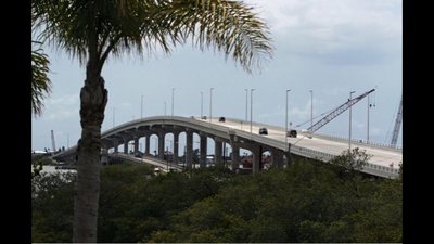
Belleair Causeway, Road bridge in Belleair Beach, United States

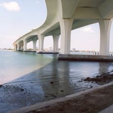
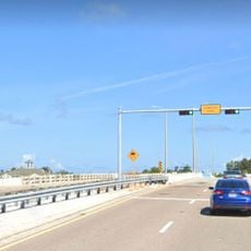
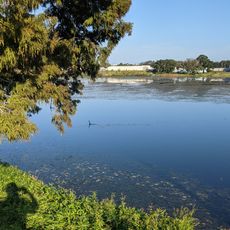
Belleair Causeway is a road bridge that spans the Intracoastal Waterway, linking Belleair Beach to the mainland near Largo. The structure has two traffic lanes and dedicated bicycle paths running the full length of the crossing.

The original structure built in 1950 was a two-leaf bascule bridge that operated for nearly six decades. It was replaced in 2009 with a modern concrete bridge designed to better serve current traffic needs.

The causeway serves as a common meeting place where locals come to fish and watch wildlife throughout the year. You will notice people spending time here with family and friends, enjoying the water views.

The bridge rises high enough to allow various boats and watercraft to pass underneath without issues. Crossing is free and straightforward for vehicles, cyclists, and pedestrians who may want to walk along the designated paths.

The old bascule bridge had an unusual feature: the toll plaza was positioned directly on the bridge itself rather than on the mainland. This rare design choice made the previous structure notably different from most similar crossings in the region.

The community of curious travelers

AroundUs brings together thousands of curated places, local tips, and hidden gems, enriched daily by 60,000 contributors worldwide.

Start exploring
Location
Location
GPS coordinates
27.91717,-82.83068
Latest update
December 13, 2025 12:23
Around this place
Clearwater Marine Aquarium
United States of America

Clearwater Marine Aquarium

6.7 km
Super Power Building
United States of America

Super Power Building

6 km
Caladesi Island State Park
United States of America

Caladesi Island State Park

11.5 km
Belleview-Biltmore Hotel
United States of America

Belleview-Biltmore Hotel

3.2 km
Pinellas Trail
United States of America

Pinellas Trail

5.7 km
Clearwater Memorial Causeway
United States of America

Clearwater Memorial Causeway

6.3 km
Tiki Gardens
United States of America

Tiki Gardens

7.2 km
Plumb House
United States of America

Plumb House

5.2 km
Fort Harrison
United States of America

Fort Harrison

5.2 km
Seminole Lanes
United States of America

Seminole Lanes

11.3 km
United States of America

Sand Key Bridge

5.1 km
Old Pinellas County Courthouse
United States of America

Old Pinellas County Courthouse

5.8 km
Largo Public Library
United States of America

Largo Public Library

4.5 km
Splash Harbour Water Park
United States of America

Splash Harbour Water Park

4.3 km
Harbor Oaks Residential District
United States of America

Harbor Oaks Residential District

5.1 km
J. O. Douglas House
United States of America

J. O. Douglas House

11.1 km
Indian Rocks Causeway
United States of America

Indian Rocks Causeway

4 km
Mount Olive African Methodist Episcopal Church
United States of America

Mount Olive African Methodist Episcopal Church

6.6 km
St. Petersburg Training Center
United States of America

St. Petersburg Training Center

8.3 km
Louis Johnson Building
United States of America

Louis Johnson Building

4.1 km
North Greenwood Library
United States of America

North Greenwood Library

7.5 km
Old Belleair Town Hall
United States of America

Old Belleair Town Hall

3.3 km
Willis S. Blatchley House
United States of America

Willis S. Blatchley House

12.1 km
South Ward School
United States of America

South Ward School

5.4 km
Louis Ducros House
United States of America

Louis Ducros House

4.5 km
Ross Norton Aquatic Complex
United States of America

Ross Norton Aquatic Complex

4.8 km
Highland Family Aquatic Center
United States of America

Highland Family Aquatic Center

5.7 km
Penny Lane, Beatles Museum
United States of America

Penny Lane, Beatles Museum

11.2 km
Show the full map
Reviews
Share your experience

No review yet

Discussions
Start a discussion...

No discussion yet

« Belleair Causeway - Road bridge in Belleair Beach, United States » is provided by Around Us (aroundus.com). Images and texts are derived from Wikimedia project under a Creative Commons license. You are allowed to copy, distribute, and modify copies of this page, under the conditions set by the license, as long as this note is clearly visible.

Discover hidden gems everywhere you go!

From secret cafés to breathtaking viewpoints, skip the crowded tourist spots and find places that match your style. Our app makes it easy with voice search, smart filtering, route optimization, and insider tips from travelers worldwide. Download now for the complete mobile experience.

Around Us App Screenshot

A unique approach to discovering new places

Le Figaro

All the places worth exploring

France Info

A tailor-made excursion in just a few clicks

20 Minutes

Around Us
Travel Guide & Maps
Download

Send to your phone

QR Code
1

Open the camera app on your mobile.

2

Point at the QR code with your camera. A notification will appear.

3

Tap the notification to open the link.