Parroquia Cocuy, third-level administrative division in the Municipio Río Negro, Amazonas State, Venezuela
Location: Municipio Autónomo Río Negro
Location: Amazonas
Part of: Municipio Autónomo Río Negro
GPS coordinates: 1.31859,-66.34751
Latest update: November 11, 2025 04:35

Pico da Neblina
68.9 km
Piedra del Cocuy
53.5 km
Pico 31 de Março
68.6 km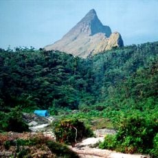
Serranía La Neblina National Park
53.7 km
Piedra del Cocuy Natural Monument
53.5 km
Castle Fort San Felipe
104.9 km
Cerro Avispa
56 km
Forte de São José de Marabitanas
60.2 km
Cué-cué/Marabitanas Indigenous Territory
80 km
Cerro Aracamuni
58.8 km
Cachoeira Tababacolei
103.6 km
Cachoeira Cumati
100.5 km
Catarata de Hua
64 km
Waterfall
65.4 km
Isla La Guama
56.7 km
Cachoeira Bacabal
78.3 km
Waterfall
68.6 km
Waterfall
72.1 km
Waterfall
72.6 km
Isla Murcielago
75.6 km
Waterfall
55.9 km
Waterfall
61.1 km
Waterfall
60.6 km
Waterfall
60.4 km
Waterfall
67.6 km
Waterfall
62 km
Waterfall
66.9 km
Waterfall
64.9 kmReviews
Visited this place? Tap the stars to rate it and share your experience / photos with the community! Try now! You can cancel it anytime.
Discover hidden gems everywhere you go!
From secret cafés to breathtaking viewpoints, skip the crowded tourist spots and find places that match your style. Our app makes it easy with voice search, smart filtering, route optimization, and insider tips from travelers worldwide. Download now for the complete mobile experience.

A unique approach to discovering new places❞
— Le Figaro
All the places worth exploring❞
— France Info
A tailor-made excursion in just a few clicks❞
— 20 Minutes