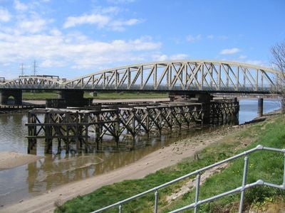
Hawarden Bridge, Railway bridge in Sealand, Great Britain.
Hawarden Bridge is a railway bridge that spans the River Dee, connecting train routes between England and Wales through a metal structure. The span sits at a modest height above the water, designed to let trains pass safely while maintaining the flow of the river below.
This bridge opened in 1889 as part of an ambitious railway project linking England and Wales more directly. It stands as one of the notable engineering achievements of the late Victorian era in British railway development.
The bridge reflects the industrial heritage of Flintshire, where Welsh and English influences merge in the architectural and engineering accomplishments of the Victorian era.
The bridge is easily accessible from nearby railway stations and serves daily train traffic between the two countries. Since it is an active railway structure, visitors should stay clear of the tracks and observe from designated viewing areas.
When completed, this structure was among the longest single-span bridges in the entire United Kingdom. The engineering approach used here demonstrated cutting methods and materials that were highly advanced for the period.
Location: Flintshire
Official opening: August 3, 1889
Elevation above the sea: 1 m
GPS coordinates: 53.21720,-3.03320
Latest update: December 11, 2025 11:04
Wepre Park
2.4 km
Ewloe Castle
3 km
Deeside Leisure Centre
1.2 km
Flintshire Bridge
2.5 km
RAF Sealand
2.4 km
Jubilee Bridge
1.3 km
St Mark's Church, Connah's Quay
2.1 km
St Ethelwold's Church, Shotton
851 m
St David's Church, Connah's Quay
1.4 km
Old Quay House Inn
1.8 km
Deeside Library
1.1 km
Connah's Quay and Shotton War Memorial
851 m
Gates, gatepiers and churchyard wall along north side of Shotwick Lane
3.5 km
Tombchest of Robert and Martha Ellison, 10 metres southwest of south corner of tower of Church of St Michael
3.5 km
The Ship Public House
1.6 km
Blessed Sacrament
1.1 km
Sundial in the churchyard of St Michael
3.5 km
Tombchest of James Phillips, 2 metres south of the sundial in the Churchyard of St Michael
3.5 km
Tombchest of John Nevett Bennett, 5 metres west of south porch of St Michael's Church
3.5 km
Tombchest of Rev M Reay and 4 children, 8 metres south of south porch of Church of St Michael
3.5 km
Tombchest of William Briscoe (died 1723) and others, 4 metres west of priest's door to St Michael's Church
3.5 km
Tombchest of William Briscoe (died 1704) and others, 5 metres southwest of priest's door to St Michael's Church
3.5 km
North Pair of Aircraft Hangars
2.5 km
South Pair of Aircraft Hangars
2.4 km
Lychgate at Church of St Mark
2.1 km
Ferry Bank Farm
1.9 km
Ewloe Methodist Chapel
3.2 km
Office Building, Corus Steelworks
141 mVisited this place? Tap the stars to rate it and share your experience / photos with the community! Try now! You can cancel it anytime.
Discover hidden gems everywhere you go!
From secret cafés to breathtaking viewpoints, skip the crowded tourist spots and find places that match your style. Our app makes it easy with voice search, smart filtering, route optimization, and insider tips from travelers worldwide. Download now for the complete mobile experience.
A unique approach to discovering new places❞
— Le Figaro
All the places worth exploring❞
— France Info
A tailor-made excursion in just a few clicks❞
— 20 Minutes