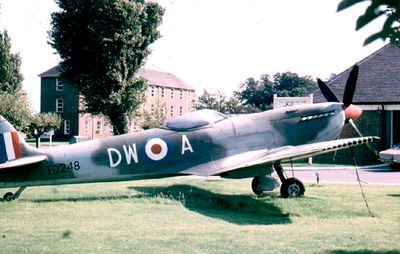
RAF Sealand, Military air base in Flintshire, Wales.
RAF Sealand is a military air station in Flintshire, Wales, with hangars, administrative buildings, and specialized training facilities spread across its grounds. The base includes maintenance workshops, clean rooms, and specialized testing chambers for advanced aircraft systems.
The station was founded in 1916 as RFCS Shotwick and served as a training airfield during World War I. It joined the Royal Air Force in 1924 and later became a major aircraft maintenance and repair facility.
The military installation inspired local musicians when Orchestral Manoeuvres in the Dark released a song called Sealand in 1981. This connection shows how the place became part of the regional music culture.
The facility is located in northeast Wales near the English border and is accessible by public transport or car. Visitors should note that it remains an active military base where access may be restricted to authorized personnel.
The base serves as a global maintenance center for F-35 Lightning II fighter jets, with advanced clean rooms and radar testing facilities. This specialization makes it a hub for cutting-edge aircraft technology in the United Kingdom.
GPS coordinates: 53.22243,-2.99796
Latest update: December 11, 2025 11:04
Hawarden Bridge
2.4 km
Jubilee Bridge
1.8 km
Shotwick Castle
1.6 km
Shotwick House
2.4 km
St Michael's Church, Shotwick
1.8 km
Shotwick Hall
2.1 km
St Bartholomew's Church, Sealand
2.1 km
Churchyard boundary wall, Church of St Bartholomew
2.1 km
Bridge Farmhouse
2.5 km
Gates, gatepiers and churchyard wall along north side of Shotwick Lane
1.8 km
Front garden walls and gatepiers at Shotwick Hall
2.1 km
Tombchest of Robert and Martha Ellison, 10 metres southwest of south corner of tower of Church of St Michael
1.8 km
Manor Farmhouse
1.9 km
Tombchest of John Nevett Bennett, 5 metres west of south porch of St Michael's Church
1.8 km
Former kitchen or bakehouse attached to north east corner of Shotwick Hall
2.1 km
Granary 30 metres east of Shotwicklodge Farmhouse
2.2 km
Sundial in the churchyard of St Michael
1.8 km
Tombchest of James Phillips, 2 metres south of the sundial in the Churchyard of St Michael
1.8 km
L-shaped ranges of farm buildings 60 metres north of Shotwick Hall
2.2 km
Greyhound Farmhouse
1.9 km
Tombchest of Rev M Reay and 4 children, 8 metres south of south porch of Church of St Michael
1.8 km
Tombchest of William Briscoe (died 1723) and others, 4 metres west of priest's door to St Michael's Church
1.8 km
South Pair of Aircraft Hangars
260 m
Tombchest of William Briscoe (died 1704) and others, 5 metres southwest of priest's door to St Michael's Church
1.8 km
Office Building, Corus Steelworks
2.3 km
Barn 70 metres north east of Shotwicklodge Farmhouse
2.2 km
North Pair of Aircraft Hangars
313 m
Ferry Bank Farm
1.4 kmVisited this place? Tap the stars to rate it and share your experience / photos with the community! Try now! You can cancel it anytime.
Discover hidden gems everywhere you go!
From secret cafés to breathtaking viewpoints, skip the crowded tourist spots and find places that match your style. Our app makes it easy with voice search, smart filtering, route optimization, and insider tips from travelers worldwide. Download now for the complete mobile experience.
A unique approach to discovering new places❞
— Le Figaro
All the places worth exploring❞
— France Info
A tailor-made excursion in just a few clicks❞
— 20 Minutes