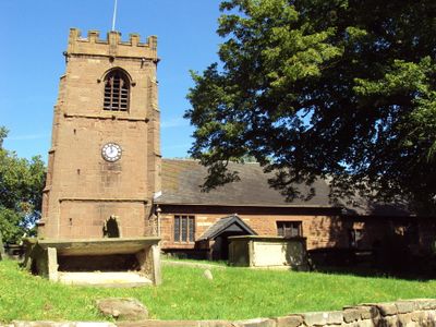
St Michael's Church, Shotwick, Medieval church in Shotwick, England
St Michael's Church is a stone building with a Gothic tower and a doorway that shows Norman style, both key features of its design. The interior is divided into a nave with four sections and a chancel with three sections, creating the typical layout of a medieval church.
The building began around 1050 at a river crossing that served as a boundary between England and Wales. This location made it a natural meeting point for people from both sides of the border.
Inside, you can see historic furnishings that show how the space was arranged for worship over time, from the box pews to the ornate pulpit with its canopied section. These pieces reflect the way people gathered and participated in religious services across different eras.
The church is open daily and welcomes visitors during morning and afternoon hours. Visiting on a weekend morning offers the chance to see the space when it is being used for its original purpose.
The graveyard holds the graves of nine Royal Air Force officers from World War I, marking a lesser-known connection to the conflict. Also scattered across the grounds are several protected structures, including an 18th-century sundial that adds to the site's historical depth.
Location: Puddington
Inception: 11 century
Architectural style: English Gothic architecture, Norman architecture
Website: https://shotwick.org.uk
GPS coordinates: 53.23880,-2.99510
Latest update: December 14, 2025 13:03
RAF Sealand
1.8 km
Shotwick Castle
1.8 km
Shotwick House
2.6 km
Shotwick Hall
284 m
Footpath Guidepost At Junction With Parkgate Road
2.5 km
Bridge Farmhouse
2.9 km
Gates, gatepiers and churchyard wall along north side of Shotwick Lane
26 m
Front garden walls and gatepiers at Shotwick Hall
274 m
Tombchest of Robert and Martha Ellison, 10 metres southwest of south corner of tower of Church of St Michael
30 m
Manor Farmhouse
107 m
Tombchest of John Nevett Bennett, 5 metres west of south porch of St Michael's Church
19 m
L-shaped ranges of farm buildings 60 metres north of Shotwick Hall
353 m
Greyhound Farmhouse
94 m
Sundial in the churchyard of St Michael
25 m
Tombchest of James Phillips, 2 metres south of the sundial in the Churchyard of St Michael
27 m
Footpath Guidepost At Junction Of Pipers Lane Opposite The White House
1.9 km
Footpath guidepost 50m east of Heath farmhouse
2.6 km
Granary 30 metres east of Shotwicklodge Farmhouse
1.5 km
Former kitchen or bakehouse attached to north east corner of Shotwick Hall
302 m
Tombchest of Rev M Reay and 4 children, 8 metres south of south porch of Church of St Michael
15 m
Tombchest of William Briscoe (died 1723) and others, 4 metres west of priest's door to St Michael's Church
7 m
Vicarage Farmhouse
58 m
Barn 70 metres north east of Shotwicklodge Farmhouse
1.5 km
Footpath Guidepost 5 Metres North Of Top Lodge
1.7 km
Tombchest of William Briscoe (died 1704) and others, 5 metres southwest of priest's door to St Michael's Church
8 m
North Pair of Aircraft Hangars
1.5 km
South Pair of Aircraft Hangars
1.6 km
Gibbet Windmill
2.7 kmVisited this place? Tap the stars to rate it and share your experience / photos with the community! Try now! You can cancel it anytime.
Discover hidden gems everywhere you go!
From secret cafés to breathtaking viewpoints, skip the crowded tourist spots and find places that match your style. Our app makes it easy with voice search, smart filtering, route optimization, and insider tips from travelers worldwide. Download now for the complete mobile experience.
A unique approach to discovering new places❞
— Le Figaro
All the places worth exploring❞
— France Info
A tailor-made excursion in just a few clicks❞
— 20 Minutes